China has just opened the worlds longest Highspeed-Railway from Beijing in the north along 2298 km to the southern boom city of Guangzhou. There were a lot of international headlines around the first train on this line. And they helped to forget the big problems with Chinese Highspeed Trains as the Wenzou train collision in the not so far past.
But the Chinese Railway policy has much bigger ambitions. It is under way to create a Highspeed Railway System in Southeast Asia, linking China to Laos and Thailand and creating connections from China to Singapore.
Laos is forcing plans for a $7 billion railway link from the capital Vientiane in the South to the Chinese border in the North (passing the towns of Phonhong, Vangvieng, Luang Prabang, Oudomxay and Luang Namtha). The construction shall begin early in 2013. The line will be completed around 2014, said Laotian Deputy Prime Minister Somsavat Lengsavad at an international rail conference in Beijing. "While the exact route isn't clear, the rail line is expected to connect the southwest Chinese city of Kunming with Singapore, passing through Laos, Thailand and Malaysia", wrote wsj.com.
The project is financed by a 30-year loan from Export-Import Bank of China, according to rfa.org. China will be responsible for the construction. "Beijing is seeking to secure raw materials from neighboring countries to feed massive infrastructure investment and its manufacturing industry", wrote wsj.com.
There is one more railway project in Laos: On December 24 a contract was signed for a US $5 billion railway line from Savannakhet to Lao Bao at Vietnam border. The construction is undertaken by Malaysian company Giant Consolidated, writes enjoy-laos.com.
Meanwhile preparations for four highspeed-railway lines in Thailand are going on. Funding is to come from a proposed 2-trillion-baht investment programme dedicated to new infrastructure projects over the next seven years. In November 2012 Finance Minister Kittiratt Na-Ranong said according to Bangkok Post the government is planning four high-speed rail lines to support trade and tourism within the country. The four high-speed rail lines are Bangkok-Nong Khai-Vientiane; Bangkok-Ayutthaya-Chiang Mai; Bangkok to Hua Hin; and an expansion of the Airport Rail Link in Bangkok to Chon Buri, Pattaya and Rayong. These plans are supported by a Study of Thailand Development Research Institute Foundation. And China is aggressively lobbying the Thai government to select its train and construction technology, writes Bangkok Post. Chinese Deputy Railways Minister Lu Chunfang told Prime Minister Yingluck Shinawatra that its construction costs average only US$20 million per kilometre compared with $81 million in Japan and $50 million in Germany. Thailand and China signed a memorandum of understanding on April 15 to conduct a feasibility study for the Bangkok-Chiang Mai and Bangkok-Nong Khai high-speed rail links. Thailands government plans to open international bidding early next year on the first phase of the high-speed rail project. Chinese government officials advising Thailand have suggested that it begins with a 54km route linking Bangkok and Ayutthaya as it would fall in line with the government's push to have the ancient capital serve as host for the 2020 World Expo, noted Bangkok Post.
Read also:
Growing Chinese influence in Cambodia:
A railway from Preah Vihear, a steel plant and a seaport in Koh Kong
Thursday, December 27, 2012
Saturday, November 24, 2012
Pitak Siam Demonstration in Bangkok
Live news now
Saturday, November 25, 17.30
"Aim_The Nation" announces on Twitter: Gen Boonlert called off the rally saying to protect lives. Does this really mean, that the demonstration will stop now? nationmultimedia.com also writes, that the rally has been called off.
Saturday, November 25, 15.30
Protesters have removed barricade blocks on Makkawan Bridge leaving no barriers between them & police, reports Aim_The Nation on Twitter. Protester's truck has moved closer to police line. Follow the news around Makkawan here. Matt Wheeler has a Police Officer saying: "We know the plan is to provoke us, to create images of police using force against the people".
Saturday, November 24, 15.15
"The intention of the protesters on Ratchadamnoen Nok Rd is clear. They want to push through police lines towards Government House", writes Richard Barrow about the ongoing confrontation between protesters and police, who are blocking the road.
Saturday, November 24, 14.30
"The Nation" writes, that Defence Minister ACM Sukampol Suwannathat has ordered Army chief Gen Prayuth Chan-ocha to prepare troops to assist police to keep law and order should police fail to control the situation, a source said. The source said Prayuth in turn ordered the First Division, the Second Cavalry Division and the Anti-Aircraft Artillery Division to prepared 8 companies of troops each to provide reinforcements to police when asked to. Police fired teargas at protesters again at 1:30 pm as they made another attempt to break via the police line at the Misakawan Intersection, notes The Nation.
Saturday, November 24, 13.15
Pitak Siem rally participation is under exspectations. Pitak Siam leader Gen Boonlert Kaewprasit initially planned to discontinue the rally at 11 am had the number of protesters been less than 50,000, as The Nation writes. Now he has decided to wait longer because he learned that provincial people were still travelling to join the rally.
Saturday, November 24, 12.30:
Pitak Siam rally against Thailands government on Royal Plaza in Bangkok has started this Saturday morning. There has been some confrontation between anti riot police and protesters, the police used tear gas. See video on youtube. "The first clash happened at Makawan Rangsan Bridge at about 9am when the protesters tried to march through the police barricade to join the rally at the Royal Plaza. They refused to make a detour to the Wat Benjama Intersection and First Infantry Intersection, where police allowed the demonstrators to pass through", reports nationmultimedia.com. So police fired teargas at the advancing protesters. Police arrested 132 protesters. "In the second clash, Police fired teargas at protesters at the Miskawan Intersection to try to prevent them from breaking through police barricade at the Miskawan Intersection at about 10 am".
Now it is not really clear, what will happen next. But Blogger Richard Barrow is at the rally and reports live on Twitter, what he can see. He says: "This weekend, it's not advisable for tourists to visit Dusit Zoo, Vimanmek Teak Mansion, The Marble Temple & the Ananta Samakhom Throne Hall". Follow Richard Barrow on Twitter.
Also Thai Blogger and journalist Saksith Saiyasombut has a Tweet from the rally. And there is a good live coverage on asiancorrespondent.com. More live Tweets by Aim_The Nation.
See also Live TV by T News TV and by Thai PBS and by Spring News TV.
See the latest pictures on flickr.com
Roads blockey by police:
 Graphic by Bangkok Post
What this blog announced before Saturday November 25
On November 24 and 25 a big anti-government-rally is planned in Bangkok by Pitak Siam Group. Traffic police has cloased roads around Royal Plaza Friday morning. Prime Minister Yingluck Shinawatra said on TV, the rally poses a threat to national security. She said intelligence reports indicated that the protesters would use violence and storm government buildings. Pitak Siam group spokesman - Air Marshal Watchara Ritthakanee - answered the group's rally at the Royal Plaza on Saturday and Sunday will be non-violent and that the movement will not move the crowd to Government House or Parliament.
On these days Tourists should avoid the area around the Thai Parliament, Dusit Zoo and Government House, says the German Foreign Office. Follow the news on Bangkok Post. See, where the Parliament and Government House are on Bangkok Hotels Google Map. Read News on Twitter about Pitak Siam. Follow Live Blog by Richard Barrow
The so called Red Shirts, who are supporting the government, also prepare für a rally on November 24. They will gather in Nonthaburi, Samut Prakan and Pathum Thani. And they announced they will march into Bangkok, if anybody should try a Military coup. Read Reds prepare for coup danger.
Saturday, October 27, 2012
A very special coffee from Elephant Dung or just a very big PR show?

Where is the coffee bean on this picture?
It went around the world in the last days: "Would you pay US$50 for a cup of elephant dung coffee?", cnngo.com asked and continued: "The big story these days is coffee made with beans that have been pooped out by elephants". Thai elephants produce the most expensive coffee worldwide. Hotels of the Anantara Group serve this coffee. And newspapers around the world have published this message eagerly.
Is this a story that can be trusted? Is it good for elephants, when you drink elephant dung coffee? Do elephants normally eat coffee beans and poop them out afterwards? Of course there is a homepage, that tries to tell you this: blackivorycoffee.com. You learn: "Coffee beans are naturally refined by Thai elephants at the Golden Triangle Asian Elephant Foundation in Chiang Saen, northern Thailand." Naturally? Do elephants normally eat coffee beans? Try a Google Archive Search about elephants and coffee beans for example for the year 2010 - and you will find nothing. Therefore also blackivorycoffee.com tells you, that "in times of drought", Asian elephants are attracted to coffee plantations "as many of them are irrigated". Then they eat, what they find here - but not normally, when there are not times of drought.
So how do the elephants at the Golden Elehant Triangle Foundation get their beans? You guess it: They are fed with beans. Before the best Thai Arabica beans have been picked from an altitude as high as 1500 meters. So: What is promoted as a natural process really is a man made process.
Does this harm the Elephants? The Black Ivory Coffee Company assures: "Blood work has been completed by independent veterinarians to confirm that there has been no harm to the elephants. An elephant veterinarian is also on-site at the production site full-time." So you learn: The Elephant camp is a "production site".
And who earns the money from this production? "8% of our sales will help fund a specialist elephant veterinarian to provide free care to all the elephants of Thailand through the Golden Triangle Asian Elephant Foundation. Additional funds will also be used to purchase medicine as well as to build a new laboratory", says the homepage of blackivorycoffee.com.
And who founded this business with elephants? It is Blake Dinkin. Before he was active in northern Thailand, he was active in Rwanda in Africa, as you can learn on The business of doing good. Dinkin, a Torontonian, has completed his MBA at the University of Geneva (Switzerland). He then went to Africa through a Canadian non-profit group called MBAs Without Borders (MWB).
And Blake Dinkin is also on Facebook. He writes there about the article Elephant Dung Coffee: World's Most Expensive Brew Is Made With Pooped-Out Beans on huffingtonpost.com. He says: "It's amazing how one article can lead to coverage in so many other sites. I have just received an invite to a fantastic PR opportunity." Well, this is it: A big PR show.
Sunday, May 6, 2012
Bangkok Impressions
 Picture by Jurgen Proschinger
View from Wat Arun across Chao Phraya River
 Picture by runran
Woman at the Thewet fish market
 Picture by Jurgen Proschinger
Wall painting in Wat Phra Kaew
 Picture by Jurgen Proschinger
Vimanmek Palace
 Picture by tiseb
Abhisek Dusit Throne Hall
 Picture by Wat Piece (formerly Wat suandok)
Wat Peace, seen from Thewet Pier
 Picture by m-louis
View from Isetan Shopping Mall
 Picture by David Darricau
 Picture by adaptorplug
Chinese Cemetary, Silom Road
 Picture by Xin Li 88
Food stalls in front of defense ministry at Kalayana Maitri Road.
 Picture by Xin Li 88
Kings Birthday, Sanam Chai Road
Tuesday, April 3, 2012
Prevent the next flooding of Bangkok: Move people out of forests?
It sounds very special, what you could read in The Nation: Forestry experts and environmental activists called on the government to move people out of mountainous areas of Thailand, to protect forests and prevent floods.
The proposition was made at a seminar titled "Headwater Forest Strategy and the Way to Prevent Flood and Drought" organised by the National Parks, Wildlife and Plant Conservation Department. About 350 people took part, including forestry officials, forestry experts, environmental activists and members of civic groups.
A study conducted by the Natural Resources and Environment Ministry found that massive deforestation caused by commercial farming in mountainous areas (500-1,500 metres above sea level) was one of the major causes of last year's severe flooding. More than 3.7 million rai of headwater forest in six river basins including the Ping, Wang, Yom and Nan were severely damaged by commercial farming (maize and rice). "We need to reduce the population in the mountainous areas and control land use. Moving people from mountainous areas to lower-lying areas would be a good way to protect headwater forests," said Wattana Wachirodom, an official from the Forest and Water Crisis Management Network.
The government may not follow. Natural Resources and Environment Ministry permanent secretary Chote Trachoo said he disagreed: "Relocating millions of people out of mountainous areas would be a very, very big issue," he said. Instead Chote Trachoo said, the government will pay people living in mountainous areas to plant trees and protect forests.
This created a lively debate on thaivisa.com. "I think that the worst damage is being done by a few very wealthy people who are engaged in illegal logging and massive deforestation and who do not even live close to the forest environment", points out one member. Another arguments, that thirty percent for the money for planting trees will go to the paymaster.
In the same time, during March, northern provinces as Chiang Mai, Chiang Rai or Mae Hong Son were hardly hit by air pollution from burnings again. People were wearing masks, visibility on streets was low, as The Nation noted. See video on youtube by guzzlalex. And tourism was hit, as guesthouse-owner Buddy Maupin described in Bangkok Post. Researchers say, this haze comes especially from the cultivation of corn crops. Research data and field examinations by the Chiang Mai office of the Natural Resources and Environment Ministry show, that the hotspots are areas cleared by burning in the dry season for growing of the same crop every year. "If we allow the practice to continue I'm afraid that within the next 10 years we will lose almost all our forests", said Bunpot Kantasen, chief of the local office, according to Bangkok Post. Officials believe mono-cropping has been encouraged by the government's ethanol use policy which has resulted in higher price for crops such as corn.
So, what should be done?
Saturday, February 18, 2012
Bomb blasts rock Bangkok
Police seeko to more over blast: A third Iranian has been arrested in Malaysia. Iranians are suspected to be part of a team targetting Israeli diplomats in Thailand. Materials found in the blast, including C4 explosives and magnets to secure the bombs to cars, were similar to those used in attacks earlier this week against Israeli diplomats in India and Georgia. (Bangkok Post, 18.2.2012)
Bangkok Governor tells people not to panic - Shopping Malls beef up security: The British embassy on its website has urged its nationals to "exercise caution" in several provinces including Chiang Rai and Ubon Ratchathani. (Bangkok Post, 16.2.2012)
Bombers 'part of terror group': The suspects involved in Tuesday's multiple bombings in Bangkok were part of the same network of terror involved in bomb incidents in India and Georgia earlier this week, according to Itzhak Shoham, Israeli ambassador to Thailand. (Bangkok Post, 16.2.2012)
Three bombs exploded in Sukhumvit area - Iranians involved - Israeli may have been target: Attack in front of Kasem Phithaya School on Sukhumvit Soi 71. Man with Iranian passport supected, other Iranian arrested at Suvarnabhumi Airport. Isreal says, Israeli were target. (Bangkok Post, 15.2.2012)
Terror case suspect 'had explosives in two houses': Police have found bomb-making materials in another house rented by Swedish-Lebanese terror suspect Hussein Atris in the Mahachai area of Samut Sakhon.(Bangkok Post, 22.1.2012)
Second terror suspecr sought: The Criminal Court on January 19 approved an arrest warrant for an alleged accomplice of Lebanese national Hussein Atris. (Bangkok Post, 20.1.2012)
A detained Lebanese Hezbollah terrorist suspect was part of a planned attack on the Chabad Jewish community centre near Khao San road in Bangkok. Says a news website which specialises in intelligence reporting. (Bangkok Post, 17.1.2012)
Police are hunting a terror suspect believed to be in Bangkok. The number of foreign embassies issuing travel warnings to Thailand increased to 11 Saturday 14.1.2012. (Bangkok Post, 15.1.2012
Sunday, January 22, 2012
Where to go on Chinese New Year
 Picture by gerrypopplestone
Chinese New Year at Wat Mangkong Kamalawat
Say goodbye to the Year of the Rabbit and hello to the Year of the Dragon: Bangkoks Chinatown celebrates Chinese New Year on Monday (January 23) and until Tuesday. There will be street parties with drums, dragons, firewirks, a lion dance contest, Chinese opera, fashion shows and a lot of Chinese food. HRH Princess Maha Chakri Sirindhorn will preside over the opening of the Bangkok Chinatown Festival 2012 on January 23 at 5 pm. This takes place at the King’s Birthday Celebration Arch at Odeon Circle. Two cultural shows, one presented by Thais and the other hosted by China's Ministry of Culture, will be performed, followed by a one-and-a-half-hour Yaowarat Cultural Showcase. Some streets in Bangkoks Chinatown are turned to Walking Streets from 6 pm on Sunday 22 until 4 am on Tuesday 24.
Already Sunday is a good time to visit Chinaatown, "as everyone is getting ready for the Chinese New Year", writes Richard Barrow on thaitravelblogs.com. Tipps for a Walking Tour and a Map: Explore the heart of Chinatown
More activities:
Shows by Chinese artists at shopping malls: At Parc Paragon of Siam Paragon, Discovery Plaza of Siam Center and Siam Discovery and at the Central Court, 1st floor of CentralWorld. Read more.
Bangkok's 5 most luxe menus for Chinese New Year: Read on lifestyleasia.com
Big celebrations for Chinese New Year also happen in other cities of Thailand:
In Suphan Buri, celebrations will take place from Jan 23-29 at the Museum of the Descendants of the Dragon. In Ayutthaya, the festival will take place from Jan 24-29 along Naresuan Road, from Chao Phrom Market to Chao Ai Chao Yi Chedi. In Ratchaburi, celebrations will take place from Sun, Jan 22-26 in front of the Ratchaburi National Museum. In Nakhon Sawan province, also known as Pak Nam Pho, the ongoing celebrations citywide will last until Jan 27. In Chiang Mai, celebrations will take place during Jan 23-24 at Lao Chow Lane. The Chinese National Opera will perform on Jan 24. In Phuket the Phuket Chinese New Year Festival 2012 will be held from Jan 28-30 at Phuket Old Town on Klang, Thalang and Thepkasatri roads. Read more on thaitravelblogs and on bangkokpost.com
Monday, January 2, 2012
Latest news about the flood in Bangkok:
11 districts go back to normal life - and where normal life is not yet back
As a special service for its readers this blog is collecting latest news about the flood in Bangkok:
4.1.1012
City plan designates new flood zones: The great flood that hit 36 districts of Bangkok will likely provide a good opportunity for adjusting or adding new water management regulations to Bangkok's new city plan and encourage greater coordination among the city's neighbouring provinces to implement a five-province city plan at the macro level. The city plan designated open areas as flood ways on two sides of Bangkok _ the west and the east. Open areas are in two coloured zones - green for agricultural purposes only and a white with green diagonal stripes zone for rural conservation and agriculture. New construction in these two coloured zones is limited, with a fewer number of buildings per area in order to have more open space.
2.1.2012
A casualty of flood: Patravadi Theatre quits Bangkok and moves to Hua Hin for good: The water comes to Patravadi Theatre every year, like to everyone else in soi Wat Rakang. This year it arrived in much greater quantity and stayed there longer than usual, but long enough to force Patravadi Theatre to close its door for good. The damage is too great to turn the place back into a functioning theatre once more. But its owner Patravadi Mejudhon is least sentimental about the loss. (Bangkok Post)
7.12.2011
Don Mueang Airport in Bangkok has been closed, Suvarnabhumi Airport is operating normally.
See flight status on Suvarnabhumi Airport.
See informations about airlines and travel waivers
Nok Air now flies from Suvarnabhumi Airport. See Nok Air Schedule from October 27 till November 30
Buses in and out from Bangkok: North and Isan bus routes changed. Southern Bus Terminal on Boromratchonnanee Road reopens November 23.
2.11.2011 BMTA: Most city buses still in service:
Tourist information: Current situation in Bangkok and also Thaizer Bangkok Flood Updates
Google Flood Crisis Map now in English:
- Severely affected areas - urgent help needed
- Flooding extents
- Bangkok risk areas and water barriers
- Shelters (for evacuated people)
- Flooded Highways
and more
More Soucres of Information about flood in Bangkok
6.03 pm Froc: Remaining floodwater no threat to Bangkok: There are still about eight billion cubic metres of floodwater to the north of Bangkok, but the city itself is safe from any fresh inundation, water management adviser to the Flood Relief Operations Command (Froc) Anond Snidvongs said Wednesday. About half of this must be stored for farm use. The rest has already flowed into local waterways, but the overflow would hardly bother the capital.
The Bangkok Metropolitan Administration (BMA) today reported that the level of the flood at Bang Sai had dropped by 11 centimetres overnight to 2.29 metres above sea level. On the Phra Nakhon side of the capital, the water level in lower Hok Wa was down by 5cm, down by 8cm at Don Muang and 4cm at Mahasawat canal. While the Thon Buri and Bang Prom canals were overflowing by 4cm Bang Waek was right at the brim and Bang Chuek remained stable.
Saen Saeb had fallen by 3-5cm, Prawet 1cm, Lad Phrao 2-6cm, Praem Prachagorn 2cm, Baen Kaen 1-2 cm, and northern Thon Buri 4-5cm, the BMA reported. (Bangkok Post)
4.12.2011
Clean-up in full swing: As no more water was flowing into western Bangkok, commercial areas should return to normal within one or two weeks, although Phutthamonthon 4 and 5 roads and Om Noi will need two or three weeks to drain, PM Yingluck said.
Bangkok Governor MR Sukhumbhand Paribatra yesterday ordered two sluice gates raised higher to drain water from Pathum Thani and Nonthaburi - while the Phrayasuren gate remained at 1.50m. Khlong Sam Wa district's Khlong Sam Wa sluice gate was raised to 1.40m from 90cm, and Min Buri district's Lam Beung Kwang gate to 1.40m from 1.30m.
A water-pushing device was placed in Khlong Thawee Wattana to lower the water level, making drainage from western Bangkok's Setthakit Ville easier, he said.
The Royal Irrigation Department yesterday opened four windows in the Chulalongkorn sluice gates, taking drainage capacity to 430,000 cubic metres per day, after the level of the Chao Phraya River (2.66m) fell below that of Khlong Rangsit Prayoonsak (2.72m) for the first time since the flooding began. This was expected to make drainage of water from eastern Bangkok faster as well.
Saying the city's main roads should be dry before year's end, Sukhumbhand said tens of thousands of tonnes of garbage remained in the capital and that he had ordered officials to collect as much of it as possible before tomorrow December 5.
Sukhumbhand's deputy, Malinee Sukavejworakit, presided over the launch yesterday of a "Big Cleaning Day" campaign in Bang Khae district in front of The Mall Bang Khae and joined the garbage-collection effort along Phetchakasem Road.
While 345 schools are due to reopen on Tuesday, 91 more schools in 10 flooded districts will reopen on December 13.
The Royal Air Force base at Don Mueang Airport is dry and ready to re-open Tuesdayon December 6.
Pathum Thani's Rangsit, Suchat and Pornpat markets and the Soi Sang Boon community started to be cleaned by residents yesterday, and should be fully clean in three days, while the 200-year anniversary Rattanakosin Housing Estate saw flood levels fall by 20cm.
4.03 pm 11 districts in Bangkok back to normal: Bangkok governor Sukhumbhand Paribatra on Sunday announced that the flood situation has now returned to normal in 11 district of the capital. These are:
- Chatuchak
- Lat Phrao
- Lak Si
- Bueng Khum
- Chom Thong
- Bangkok Yai
- Bangkok Noi
- Bang Phlad
- Phasi Charoen
- Bang Khun Thian
- Bang Bon
MR Sukhumbhand said the flood affected people in these areas, residing at temporary shelters and evacuation centres, can now return to their homes. (Bangkok Post)
12.00 am Where Bangkok is still not dry: The Froc was working with local agencies to speed up water drainage in Bangkok, so the eastern districts could be dry by month's end. People living along major roads and business areas in several flooded districts in eastern Bangkok had been able to resume their normal routines. In areas that remain flooded such as Lak Hok, Don Muang, Chaeng Watthana, Lam Luk Ka, authorities were trying to drain floodwater as quickly as possible.
Neighbourhoods above the big bag barrier are now dry, while water levels in the Rangsit Prayoonsak canal have fallen. The barrier is no longer necessary. Froc will gradually remove the big bag barrier, but it will consult people living along the barrier in advance.
Thon Buri, on the western side of Bangkok, would be dry by the end of December as well. However, it will take up to three weeks to drain floodwater from Phutthamonthon 4, Phutthamonthon 5 and Om Noi areas.
All areas in Pathum Thani and Nonthaburi provinces will be dry by New Year.
Some major canals, such as Phra Phimon canal, are still overflowing, though water levels in the Chao Phraya are likely to fall next week.
Bangkok Governor Sukhumbhand Paribatra yesterday said he expected all flooded major roads in Bangkok would return to normal by month's end. (Bangkok Post)
12.00 am Flood predicted - in a novel from 2007: A novel published in 2007 predicted the Bangkok floods with startling detail and accuracy. Bangkok Post tracked down its author, Tew Bunnag, to ask how the disaster could have been averted and what's next for the capital as it begins to rebuild.
12.00 am Five flood hit industrail estates are dry: According to PM Yingluck Shinawatra floodwater has been pumped out of five industrial estates in Ayutthaya and Pathum Thani provinces. The five are Rojana Industrial Park, Hi Tech Industrial Estate, Bang Pa-in industrial Estate, Factory Land Industrial Estate in Ayutthaya and Bangkadi Industrial Park in Pathum Thani. That leaves two flood-hit estates, Saha Rattana Nakorn Industrial Estate in Ayutthaya and Nava Nakorn Industrial Estate in Pathum Thani, which are still submerged. (Bangkok Post)
1.12.2011
12.00 am BMA raises four sluice gates: Bangkok Governor Sukhumbhand Paribatra has agreed to raise four more sluice gates to allow water from neighbouring Pathum Thani province to flow into canals now the floodwater in many Bangkok areas has receded. The order followed demands by residents living upstream that the gate be lifted to help drain water from their areas which have been flooded for more than a month. He also agreed to lift the controversial Khlong Phraya Suren watergate from 1m to 1.3m. The other three sluice gates are Khlong Sam Wa, Lam Bueng Khwang and Lat Krabang. The Khlong Sam Wa sluice gate will be raised from 80cm to 90cm to allow floodwater from Pathum Thani's Lam Luk Ka to flow into Khlong Saen Saep before the water is drained into a giant water tunnel between Rama 9 and Ramkhamhaeng roads. The Lam Bueng Khwang and Lat Krabang sluice gates will be lifted from 1m to 1.2m to drain water from Lam Luk Ka to Khlong Prawet before the water is drained to the sea through the water tunnel, the governor said. (Bangkok Post)
30.11.2011
12.02 pm School opening postponed to Dec 13: The reopening of 91 schools run by the Bangkok Metropolitan Administration has been postponed from Dec 6 to Dec 13 due to high flood levels, Bangkok deputy governor Taya Teepsuwan said Wednesday. Mrs Taya said many schools in 10 districts of the capital, such as Sai Mai, Bang Bon, Don Muang and Lak Si, remain flooded. The schools that will reopen on Dec 6 will have five-hour classes every Saturday between Dec 10 and March 3, she said. As for the schools that will resume classes on Dec 13, there will be five-hour classes every Saturday from Dec 10 to March 3 and every Sunday from Dec 18 to Jan 15. Following the reopening, studying hours on weekdays will be also extended from 3pm to 4pm until Feb 27 next year due to the postponement, the deputy governor added. (Bangkok Post)
7.44 pm West of Bangkok dry in 20 days: Veera Wongsaengnak, chairman of flood management of the Flood Relief Operations Command, said: There are about 2,700 million cubic metres of water mass on the western front. The drainage capacity to both Tha Chin and Chao Phraya river is about 67 million cubic metres a day. The floods on the western front can be drained within 20 days.
27.11.2011
7.18 pm Bangkok floods see gradual decline: Bangkok Metropolitan Administration reported that for the past 24 hours, the floodwater declines a little and some people have begun to return homes to start cleaning. BMA noted that Chao Phraya river at Bang Sai, Ayuthaya was 3.17 metres above mean sea level, a decline of 6cm. The Chao Phraya river at Pak Khlong Talat was highest at 8.15 at 2.15 metres above mean sea level, 65cm below bank.
Don Muang saw water decline about 3cm. Khlong Prem Pachakorn saw decline of 2-7cm, Khlong Bangkhen at 4-7cm, Khlong Lat Phra 4-7cm, Khlong Bang Sue 5-7cm, Khlong Hokwa and Khlong Song 2cm. On the western side, Khlong Mahasawat at Thawee Wattana sluice gate saw a decline of 3cm. Don Muang is flooded at 20-45cm, the highest at Song Prapa Rd at 45cm. The decline is the result of draining water into Khong Prem and Khlong Rangsit.
10.32 am Misery lingers for Bangkok's 'forgotten' flood victims: When the floods came, water gushed into Arunee Ninkaew's Bangkok home through the pipes and through gaps in the tiled floor. A month later it is still there, now a putrid grey breeding ground for insects. Weeks of living above the stagnant, foul-smelling floodwater, crammed into a single upstairs room with her diabetic husband, elderly mother-in-law and grandson, have left her in despair. Arunee said she wakes every morning with the same feeling of hopelessness: "I think to myself 'When? When will the water go?'"
Thailand's worst floods in half a century devastated vast areas of the kingdom and have left more than 600 people dead. They are receding in many areas, but for people in some of the capital's suburbs, the misery continues. The streets around Arunee's home in the northern district of Don Mueang are still under a metre of green water, its surface strewn with floating rubbish and glistening with petrol. The only way to get around is by boat.
Local people say they have been forgotten by authorities preoccupied with saving the shopping malls and skyscrapers of downtown Bangkok. As the floods swept south towards the capital following months of heavy monsoon rains, huge flood barriers made of giant sandbags were erected to keep the waters away from the city's commercial districts.
This tactic kept the centre dry, but at a cost: the walls have held the waters back in northern and western areas, keeping them flooded since October.
Nearly 42,000 people are living in evacuation shelters around Bangkok, but many people stayed in their homes. Arunee said that of the 400 or so houses on her estate, 20 are still occupied.
The government has begun pumping water away from some of the worst-affected areas of the city. Defence minister General Yutthasak Sasiprapa said he was confident the floods would be gone before the end of the year and urged people to be patient.
But for Arunee and her neighbours, the possibility of yet another month under water is likely to test their forbearance to the limit. (Bangkok Post)
26.11.2011
12.22 pm Trains to North and Northeast back on the normal routes: The State Railway of Thailand (SRT) has resumed its train services from today, Nov 26, on normal routes to the North and Northeast after the flood has receded, SRT public relations chief Nuan-anong Wongchan announced. They may have to go slowly between Bangkok and Ayutthaya because some parts of the rail tracks are still flooded. (Bangkok Post)
25.11.2011
Bangkok Post published this graphic 25.11.2011

12.00 am Angry protests over prolonged flooding spread throughout greater Bangkok yesterda: Residents in Bang Kae, Thawi Watthana and Taling Chan districts block part of the outbound Kanchanaphisek Road at Khlong Bang Chuek Nang, demanding information about flood management plans after flood gates in three small canals on the Thon Buri side were opened to 1m before the agreed time and the water level in their communities rose by another 10-15cm. The disputes between authorities and flooded residents continued with the latest threat coming from people in Ram Intra area who threatened to close Ram Intra Road. They are concerned the dismantling of the flood barrier at Kor Por Or intersection on Phahon Yothin Road will raise the floodwaters around their homes. National Disaster Warning Centre director Somsak Khaosuwan said officials will need to do more to protect the barriers to ensure the drainage goes as planned. "Removing the flood walls can't ease the flood situation," Capt Somsak said. "On the contrary, it takes longer to drain the flood because the water spreads. (Bangkok Post)
24.11.2011
1.16 pm Water in western Bangkok edges up: Levels in the waterways in western Bangkok have risen slightly because the capital is receiving floodwater from Nonthaburi province. The Bangkok Metropolitan Administration (BMA) agreed to open its sluice gates along Khlong Maha Sawat to receive water from Nonthaburi province, which has been flooded for over a month. As a consequence, the water levels of Khlong Maha Sawat and Khlong Thawi Watthana are rising, Bangkok Governor Sukhumbhand Paribatra said on Thursday. The opening of Khunsri Burirak, Khlong Khwai and Khlong Soi sluice gates raised the level of Khlong Maha Sawat canal by two centimetres and the level of Khlong Thawi Watthana canal was also rising, he said. (Bangkok Post)
12.00 am What went wrong with Thailands flood management? Harnnarong Yaowalers, a veteran environmental activist, explains: Harnnarong Yaowalers, a veteran environmental activist, has monitored water management at dams operated by the Electricity Generating Authority of Thailand and the Royal Irrigation Department for over two decades. He has campaigned against dam construction in Thailand and elsewhere. He says: we fix the rudimentary causes such as deforestation, problematic land use, and degradation of canals. Besides, these pricey projects will fuel more corruption. The current policy does not take into account water management upstream. The authorities haven't paid much attention to conservation of forest, nor have they tapped the utility of watersheds and wetlands as a means to absorb flood water upstream. Natural resources and canals are consistently encroached. How are we going to reclaim them, not many people talked about this problem. No one talks about the problem of public canals that would have helped drain off flood water from western and eastern parts of Bangkok had they not been trespassed by people with influence. Instead of trying to preserve nature, the government only talks about dredging new canals and new projects. Read more
12.00 am Flood-weary residents vent fury: Road blockade group clashes with motorists: Hundreds of flood-devastated residents in Pathum Thani yesterday clashed with motorists during the Din Daeng-Don Muang tollway blockade to pressure the government to accelerate assistance and the drainage of deep floodwater. The residents from several flooded communities in Rangsit and Lam Luk Ka areas, led by former election candidate Kiattisak Songsaeng, set up a blockade on the entrance of the inbound tollway in front of Zeer Rangsit department store at about noon.
The residents demanded the government's Flood Relief Operations Command (Froc) accelerate drainage of floodwaters which had affected their livelihoods for a month.
Almost simultaneously, nearly a thousand residents in Bangkok's Sai Mai and Don Muang areas yesterday dismantled a massive sandbag dyke at Don Muang's Directorate of Air Operations Control intersection on Phahon Yothin Road. The villagers, equipped with knives and sharp objects, waited for Froc representatives to negotiate. They had been asking the Froc to widen a drainage gap. However, they decided to remove the barrier after talks with Pol Maj Gen Damrongsak Kittiprapat, commander of Metropolitan Police Division 2, failed. After the flood barrier was removed, large amounts of water rushed towards Saphan Mai area. Deputy city clerk Chumphol Sampaopol yesterday said the removal of the floodwall on Phahon Yothin Road would slow down the drainage resulting in prolonged hardship.
He said some areas could be affected as the water in Khlong Mon 40 could rise by 1cm to 2cm after the barrier was dismantled. (Bangkok Post)
23.11.2011
08.52 pm Don Muang 'navigable' in 3 weeks: Seri Suparathit of the Rangsit University Centre on Climate Change and Disaster, said on Thai PBS Wednesday night that Don Muang will be navigable in 3 weeks. (Bangkok Post)
12.00 am Inner Bangkok is safe - but many Bangokians still suffer by the flood: Krissana Parnsoonthorn, Deputy Business Editor of Bangkok Post writes about the people in in Don Muang, Lam Luk Ka, Bang Bua Thong, Bang Yai, Thawi Watthana and Petchkasem areas, who will have a wet Christmas and a wet New Year and who miss plans of the government for draining the flood around their homes. Read. (Bangkok Post)
22.11.2011
12.00 am Great ideas for transport during the flood: 107 innovative projects entered in the "Mobility in the Time of Flood" contest, organised by the National Science and Technology Development Agency (Nstda) and PTT Pcl. The winning prize in the creativity category was awarded to the "2 in 1 boat" team from King Mongkut's University of Technology Thonburi's Engineering Faculty. Team member Wasan Boonleelakul explained that the boat can be powered by either a bicycle or motorcycle driving the engine, but the competition rules stipulate the sole use of manpower. "I reduced the number of gallon tanks to support the weight of a bicycle only," he said. The vehicle, which can accommodate three people, or take up to 200 kilos, is constructed from used materials that can be found anywhere, such as 30-litre gallon tanks and PVC pipes. The boat is powered by pedalling the bicycle which drives a propeller beneath the structure, while the PVC pipe serves as a rudder. Read more about the prize winners
12.00 am More Bus services are back to normal, Chao Phraya Express Boat Services resumes operation: The city bus authority has canceled special free bus services on two routes. Passengers will now need to pay, as per usual, for bus services on bus Number 29 that runs from Mor Chit 2 to the Victory Monument, bus Number 34 and 59 that run from Bang Khen to Chatuchak and bus Number 95 from Bang Ken to Bang Kapi. The fee exemption was also canceled for bus Number 543 that runs from Ramintra to Klong 7 and bus Number 516 that runs from Big King's to Kanchanapisek, Barom Ratchonnanee, Pinklao and Tevet.
Meanwhile, the Chao Phraya express boat service between Nonthaburi and Rajsingkorn Temple (Orange Flag route) also resumes operation today. (Tannetwork.tv)
21.11.2011 Floods in West Bangkok Expected to Ease in 2 Weeks: Many residents are still waiting for going home in West Bangkok, Now there is some hope. The agriculture and cooperatives minister promises that residents in the western part of Bangkok will be able to move back to their homes in the first week of December. The Department of Sewage and Drainage is hopeful the Thonburi residents will be able to return to their homes during the first week of December. Furthermore, the Tawee Wattana Canal floodgate has been raised to 50 centimeters in order to drain more water from Maha Sawas Canal to the Tawee Wattana Canal. The water level near the floodgate has receded by 30 centimeters.
However, the locals are happy about the raised floodgate despite the fact that the water level at their homes has not receded. (tannetwork.tv)
20.11.2011
Graphic published by Bangkok Post 20.11.2011 about planned floodways in Bangkok:

12.00 am Floodways key to keeping Bangkok safe: Bangkok Metropolitan Administration has published a new city plan. It plans designation of floodway zones in eastern and western Bangkok, that will help safeguard the capital from any major deluge in the future. In these zones development will be limited. The main focus will be on making use of that land as a drainage area, which should ensure speedy drainage of floodwater through those areas to the sea. Parts of Khlong Sam Wa and Min Buri districts have been declared areas to be preserved for water drainage. On the western side, some parts of Taling Chan and Bang Kae districts have also been designated as water drainage zones. (Bangkok Post)
12.00 am 11 crocodiles caught in Bangkok an Central Plains until now: Since floodwaters from the North arrived in the Central Plains, reports of crocodiles fleeing from farms and private properties have surged, prompting officials from the Fisheries Department to head into the floodwaters in search of them. They have been able to catch 11 crocodiles. Since the floods began, some have even surfaced in Bangkok, though no injuries have been reported. Crocodiles caught by fisheries officials are kept at fisheries centres in Chon Butri and Suphan Buri until staff decide what to do with them. (Bangkok Post)
12.00 am Agreement with residents about Big Bag: The ongoing dispute between flood-hit residents and authorities over the Khlong Hok Wa flood barrier ended yesterday with residents agreeing to not breach the dyke and authorities promising to widen three sluice gates. (Bangkok Post)
19.11.2011
12.00 am Flood affected Bangkokians get 5000 Bath from government - but how? City Hall is stepping in to clarify details of the government's scheme to provide financial help to flood victims. But questions have arisen as to why only the legal owners of flooded houses are entitled to receive the aid, and what documents should be submitted along with their application for assistance. The government says 621,355 households in the capital have been hit by the floods. The cabinet has decided to set aside about 3.1 billion baht to help them. Bangkok Governor Sukhumbhand Paribatra said he had told all 50 district offices to start registering flood victims under the programme. Two types of flood-affected households were defined as: those flooded as a result of a sudden incident that damaged a house; and prolonged flooding of at least seven days which damaged property. In both cases, the houses or properties must be located in areas declared flood-affected zones, said the governor. The legal house owner is required to submit a copy of his or her house registration document and ID card with authorities. Tenants are required to submit a copy of their rental contracts and ID cards. Flood victims should visit http://www.bangkokgis.com/flood or call 1555. A total of 32 districts of Bangkok are regarded as flood zones: Bang Kae, Bang Khen, Bang Kholaem, Bang Phlat, Bang Sue, Bangkok Noi, Bangkok Yai, Chatuchak, Din Daeng, Don Muang, Dusit, Kannayao, Klong Sam Wa, Klong San, Klong Toey, Laksi, Lat Krabang, Lat Phrao, Min Buri, Nong Chok, Nong Khaem, Phasicharoen, Phra Nakhon, Rat Burana, Sai Mai, Samphanthawong, Sathon, Taling Chan, Thawi Watthana, Thon Buri, Wang Thonglang and Yannawa. "Flood victims should be able to receive payments from Dec 20 onwards, and City Hall will not impose a deadline of relief applications as we realise that flooding situations are different across the city," said the governor.
The Bangkok Metropolitan Administration is also drafting legislation to allow additional assistance of 1,500 baht per household for flood victims in Bangkok, he said. Service points could be opened in flooded areas to help with registration. (Bangkok Post)
18.11.2011
Six injured in explosion at floodwall - Khlong Hok Wa barrier row erupts into violence: Six people have been injured by an explosive device thrown into a large crowd who were trying a fix a breach in a sandbag flood barrier in Bangkok's Sai Mai district last night. The blast followed a dispute over the sandbag flood barrier at the lower line of Khlong Hok Wa in the district. Police found debris of what appeared to be a brick attached to gunpowder. The package was thrown onto the bridge across the canal where around 100 residents were trying to close a 70m-wide gap in the barrier. Police said the incident was aimed at stirring up a confrontation between residents on both sides of the flood barrier. Crowd-control police from the Metropolitan Police Division 2 were deployed to beef up security.
The 70m-wide gap was created in the morning when about 300 Pathum Thani residents dismantled a stretch of the sandbag flood barrier at the lower line of Khlong Hok Wa.
The breach caused more floodwater to surge into Sai Mai district. The Khlong Hok Wa flood barrier is one of the two major barriers that block floodwater in Pathum Thani from surging into the northern part of Bangkok. (Bangkok Post)
17.11.2011
3.14 pm Khlong Hok Wa barrier torn down: About 300 residents in Pathum Thani tore down a stretch of a sandbag flood barrier at the lower line of Khlong Hok Wa, causing more floodwater to surge into Bangkok's Sai Mai district, on Thursday afternoon. The level of floodwater then rose from the previous 20cm to between 30cm and 40cm. Officials led by Pol Maj Gen Damrongsak Kittiprapat, chief of Metropolitan Police Division 2, were at the scene and in negotiations with the angry residents. (Bangkok Post)
12.32 pm New warning for Samae Dam area: The Bangkok Metropolitan Administration on Thursday declared more parts of Samae Dam sub-district of Bang Khun Thian district evacuation areas. The new areas are various sois off Bang Khun Thian Road from the intersection with Rama II Road to Wong Wian Yai-Mahachai railroad. The announcement said water was rising steadily in Bang Khun Thian district. (Bangkok Post)
16.11.2011
9.07 pm Floods for a while in Nonthaburi and Pathum Thani: Assoc Prof Dr Seri Suparathit of the Rangsit University Centre on Climate Change and Disaster, said on Thai PBS Wednesday night that Nonthaburi and Pathum Thani residents on the western front have to live with floods for awhile as Chao Phraya river still overflows its banks.
New Big Bag breach at Phahonyothin poses no problem for Bang Sue drainage station. In fact, the station's capacity right now is greater than replenishment. That's why floodwater recedes from both Vibhavadi and Phaholyothin, although it is still deep at Government Complex at Chaeng Wattana Rd. (Bangkok Post)
3.56 pm Bang Kapi people advised to evacuate: Eight communities in the Bang Kapi area were advised to evacuate to safer ground on Wednesday because the flood is approaching their homes.
The eight communities are Wang Yai, Wang Some, Samakki Pattana, Lamsalee, Lamsalee Pattana, Yoo Sabai housing estate, Majcha and Pracha Ruam Jai. (Bangkok Post)
12.00 am City Hall's false evacuation alert leads to chaos
A false alarm issued by City Hall urging Bangkok residents living along the banks of Khlong Bang Sue to evacuate late on Monday night triggered chaos in the inner-city district of Phaya Thai. (Bangkok Post)
6.07 am Boat service by the Navy in Thonburi: The Navy's water-transport service has been available from 8am-8pm every day since Saturday.
The eight routes are Tha Phra Intersection-The Mall Bang Khae, Charan Sanitwong Soi 13-Wat Maphrao Tia, Bangkok Naval Base-Buddhamonthon 4-Thawee Watthana, Soi Kamnan Maen-Bang Khae Market, The Mall Bangkae-Phetkasem 69-Bang Bon, Siriraj Hospital-Pata Pinklao Mall-Sirindhorn-Krung Thon Bridge, Bang Khun Non-Bang Phlat-Rama VII Bridge, and Siriraj Hospital-Central Pinklao Mall-Southern Bus Terminal. (The Nation)
15.11.2011
Graphic published by Bangkok Post 15.11.2011

United Kingdom lifts advisory against travel to Bangkok: The United Kingdom's Foreign and Commonwealth Office (FCO) has downgraded its warnings for visitors to Thailand. On Monday, the FCO changed its advisory and is now telling travelers to exercise caution when visiting the country's 22 flood-stricken provinces, including Bangkok. Previously, it advised against all but essential travel. (CNN)
9.10 pm Rama II - Bangkoks highway to the South - 'will be navigable': Dr Anond Snidvongs, GIS expert working for Froc, reported live from Rama II, Soi 69 on NBT: Floodwater will continue to rise at Rama II Rd about 5-7 days and stabilise.
It will rise to the level of Rama II road and will submerge the road in some sections but small cars can navigate. Froc tries to expedite waterflow to Khlong Mahachai's water retention area. It would take about 2 weeks before Soi 69 can see receding water due to its low-lying area nature.
About Bangkok North and East, water recedes in several areas. Soon more roads will be dry. However, low-lying areas will take longer to dry. Fortunately, water up Big Bag is receding. So Big Bag gap will pose no problem. Khlong Prem Pachakorn can accommodate more water. Water above Big Bag can flow to Khlong Prem as well. (Bangkok Post)
8.16 pm "Nothing can threaten Bangkok now": Asst Prof Dr Sombat Yumeang of Chulalongkorn University's director of Centre of GIS Research for Thailand on Tuesday night TNN 24 tv flood analysis sees nothing can threaten central and inner Bangkok now. Even though Big Bag is allowed to act as a weir letting more floodwater in, the waterflow rate poses no problem for Bangkok Metropolitan Authority's drainage capacity right now. More and more formerly flooded areas in Bangkok North are beginning to dry. (Bangkok Post)
3.16 pm Water down on Ratchada-Lat Phrao:
The water level on Lat Phrao Road from the Ratchadaphisek-Lat Phrao intersection to Lat Phrao Soi 39 (Soi Phawana) was down to 30cm; the water on Ratchadaphisek Road from the intersection down to Khlong Bang Sue near the Chao Phraya Park hotel also fell to 30cm. However, the roads were still impassable to small vehicles. (Bangkok Post)
12.53 pm Flood closes six public parks: Closed now: Vachira Benjathat and Chatuchak parks in Chatuchak district, Rommani Thung Sikan park in Don Muang district, Keela Ram-Intra park in Bang Khen district, Thawi Wanarom park in Thawi Watthana district, and Suan Luang Phra Ram 8 in Bang Phlat district. (Bangkok Post)
12.53 pm PM: West might be flooded into NY: The west of Bangkok might remain flooded until after the New Year, Prime Minister Yingluck Shinawatra said Tuesday. (Bangkok Post)
3.02 am How Bangkoks Skytrain system is protected against the flood - and when it could be hit too. Any substantial increase in the amount of floodwater would make the situation critical at the electrical substation, where the power supply is distributed to the train network. The substation is located at the depot beside the BTS terminus station Mo Chit in north Bangkok, where Siemens maintains the trains. Right now the situation is not critical. (The Nation)
13.11.2011
1.53 pm Bang Pa-in industrial estate is reopening December 16: North of Bangkok, in Bang Pa-in industrial estate in Ayutthaya, a lot of water has been drained out now and sent to the direction of Bangkok (Bangkok Post)
1.17 pm Highway 340 - as way to the South - opens on Monday: Highway 340 is expected to be open to traffic tomorrow, Nov 14, Transport Minister Sukampol Suwannathat said on Sunday. The government aims to use Highway 340 (Bang Bua Thong-Suphan Buri) and Highway 9 (Kanchanapisek road) as an altenative route to the South after Rama II road has been flooded. (Bangkok Post)
11.47 am More evacuations near Rama II: The Bangkok Metropolitan Administration on Sunday declared three communities off Rama II road in Samae Dam sub-district of Bang Khun Thian district evacuation areas.
They are the Karn Kheha community 1, Sapsin Pattana community, and Chuam Samphan community in Soi 88 off Rama II road. (Bangkok Post)
11.32 am Water receding on some main roads: The water has receded on Ratchadapisek, Vibhavadi Rangsit and Phahon Yothin. The outbound lanes of Phahon Yothin road from Lat Phrao intersection to Ratchayothin intersection was still under 30-40 centimetes of water and impassable to small vehicles. Kaset - Navamin road leading Bang Kapi was flooded to the level of the footpath. On the Thonburi side of Bangkok, water in Khlong Maha Sawat at Thawi Watthana watergate has been stabilised. (Bangkok Post)
Video on Youtube: Srinakarin Road
Video: Bangkok Flood Diary 10 - '4 Dogs in a Boat (To Say Nothing of the Humans)'
Video of Pata Pinklao and near Central Pinklao
Video from Bangkhae/Petchasem
12.11.11
9.06 pm Rama II may be spared closure: Dr Anond Snidvongs, GIS expert working for Froc, provided a daily flood analysis on NBT. All provinces along Chao Phraya river see declining floodwater level. Areas that still see flood level rising are Bangkok and Thonburi. Bangkok East now sees floodwater arrive at Khlong Prakanong, Khlong Prawase to be drained to the sea. The floodwater flow speed takes longer than expected, but it means that the government's effort to drain excess water to the East works. Khlong Bang Sue can hold invading floods for 5 days now. BMA's canals, Bang Sue, Bang Khen, Lak Si, Lat Phrao work well together with Big Bag slowing down the inflow. Lak Si, Don Mueang see declining water level. It will take about 7-10 days to drain main roads dry. Phya Thai, Khlong Toey, Silom, Sathorn [economic hub] are unlikely to see any flood. Bung Khum, Khlong Samwa are still worrisome. Bang Chan, Minburi see rising water, but the rising rate is now stabilising. Bang Kapi may see a little water about 10-20cm deep from overflowing Saen Saep canal. Khlong 8,9,10 closure helps a lot in slowing the inflow to Bangkok. The western side (Thonburi) sees wider flood spread, but not deep. Khlong Mahasawat canal sees declining water a little due to Royal Irrigation Department's effort in pumping water into Tha Chin river. Khlong Thawee Wattana also sees declining water level. Khlong Phasi-Charoen is now stable, meaning floodwater has spread wider, but shallower. Chomthong, Nongkhaem districts begin to see floodwater.
Rama II Rd is still navigable. If the effort to expedite waterflow succeeds, Rama II Rd will be flooded not so deep to warrant road closure. (Bangkok Post)
10.11.2011
Water recedes in some parts of Bangkok, but there also new evacuations: Floodwater has receded by one to four centimetres in several eastern and western districts of the capital city, Bangkok Metropolitan Administration spokesman Wasant Meewong said on Wednesday. The districts where water had dropped by 1-4cm were Sai Mai, Bang Sue, Nong Chok, Lat Krabang, Khannayao, Lat Phrao, and Thawi Watthana. In Bang Phlat district alone, the water level dropped another 10cm to about 40cm high.
However, the water levels in Min Buri and Khlong Sam Wa districts east of Bangkok went up 1cm..
The floodwater on Phahon Yothin and Vibhavadi Rangsit roads did not spread further to elsewhere.
More water pumps have been installed at Khlong Samsen, Bang Sue, Bang Khen Mai, Phraya Ratchamontri and Sanamchai stations and are all running in full capacity. (Bangkok Post)
01.23 pm More evacuation areas announced: The Bangkok Metropolitan Administration on Thursday declared parts of three districts flood evacuation areas.
They are: Bangkok Noi district (Bang Khun Si and Arun Amarin subdistricts); Chomthong district (Kamnan Maen road, Soi Ekachai 8, Soi Ekachai 14, Soi Ekachai 36, Soi Kamnam Maen 28, Soi Wuthakat 42, and Sala Kruen Ruamjai community); and Bang Bon district (Kamnan Maen 3, Suan Phak, Rim Khlong Phraya Ratchamontri, Wat Noi, Khlong Bang Phran Pattana, and Rang Phai communities; Sangsit, Passakorn 2, SK, Thanabodi, Thuanthong, Wararom, Bang Bon Garden Ville, and Bang Bon Ville housing estates; Bang Bon, Suksawat, and Sirichai markets; Bang Bon housing village, and Ban Nai Rian school in Bang Bon sub-district).(Bangkok Post)
4.31 pm More roads closed by flood: The city police Traffic Control and Command Centre on Thursday announced the closure of more flooded roads in Bangkok after the water levels rose to a critical point. In northern Bangkok, the centre said small vehicles were advised to avoid the part of Kamphaeng Phet 2 Road behind the Mor Chit 2 bus terminal that was now covered with water about 30cm deep. However, the part of the road from in front of the bus terminal to the Marketing Organisation for Farmers intersection was still dry. The Mor Chit 2 bus terminal is not much affected by the flooding yet normal services are still operating.
In eastern Bangkok, small vehicles were told to avoid the Maha Nakhon intersection on Suwinthawong Road that was about 50cm deep in floodwater. Motorists travelling into Bangkok from the eastern side are advised to instead use Ruam Phatthana Road, Luang Phraeng Road, and then Motorway Road. People travelling out of Bangkok to the East are advised to instead use Motorway Road, Luang Phraeng Road, Ruam Phatthana Road and then Suwinthawong Road to Chachoengsao. (Bangkok Post)
02.16 pm Bangkok-Samut Sakhon trains halted: The State Railway of Thailand on Thursday announced it has suspended train services between Wong Wian Yai station in Bangkok and Mahachai station in Samut Sakhon, on the Gulf, because of flooding on part of the intercity rail link. The rail tracks between Bang Bon station and Rang Pho station were this morning covered with floodwater about 50cm deep. (Bangkok Post)
9.11.2011
12.00 am Bangkok still tries to keep the inner city dry: The Bangkok Metropolitan Administration is making a big effort to drain floodwater from the northern outskirts through Khlong Bang Sue in the hope of protecting the heart of Bangkok. Massive runoff from the north surging toward Phahon Yothin, Vibhavadi Rangsit and Ratchadaphisek roads are being blocked by Khlong Bang Sue which cuts across the three roads at Chatuchak intersection, near Sutthisan intersection and in front of the Chaophya Park Hotel respectively. The BMA has installed 17 water pumps at Khlong Bang Sue and is running them at full capacity to drain overflow into the Chao Phraya River. But overflow from Khlong Bang Sue has flowed through sewers in nearby areas.If the floods pass across Khlong Bang Sue, they will head to Saphan Khwai before reaching Victory Monument.
But Seri Supparathit, director of Rangsit University's climate change and disaster centre, said yesterday that big sandbags in northern Bangkok would delay inflows of floodwater from upper areas of the city for only seven days.
"But in seven days, water will overflow the big bags and gush in at a rate of about 100 cubic metres per second. I think in seven days, water will reach Victory Monument and Ratchathewi district," Assoc Prof Seri said.(Bangkok Post)
6.11.2011
Graphic published by Bangkok Post, 6.11.11:

5.09 am Bangkok likely to flood, water expert: The promise that the 20 districts in Bangkok which remain dry would not flood was now hardly credible, according to a lecturer from King Mongkut Institute of Technology Lat Krabang with expertise in water and flood management. Drainage of flood water on both sides of the capital was disproportionate compared to the colossal mass of water threatening the capital, Asst Prof Khomsan Maleesee, of the KMITL's Faculty of Engineering said.
12.00 am More areas at risk due to lack of organisation: With the city centre, Suvarnabhumi airport and two industrial estates at risk, officials have been racing against the clock to drain water out of the eastern part of Bangkok through the city's canal system. However, a lack of coordination between water management officials at both the city and national level has probably put more areas in danger. In a worst-case scenario, the only option to solve the crisis would be to let the water drain through floodways _ which are not regulated by gates or pumps _ resulting in no control over the flow. (Bangkok Post)
5.11.2011
Flood nears inner Bangkok: Flood water is now closing in on Bangkok’s inner zone. Runoff has already submerged the Lat Phrao intersection, forcing the closure of the CentralPlaza shopping complex in Lat Phrao. Four subdistricts in Bangkok's Chatuchak district have been declared "evacuation zones". These are Khlong Khwang, Bang Duan, Bang Wag and Bang Chak.
In Bang Khen district, the water level rose by between 20 and 50 centimetres; in Chatuchak district, the water level increased by 20 centimetres; in Lak Si district the water level rose by between 30 and 120 centimetres, and a crocodile was sighted; in Klong Sam Wa district, the water level jumped by between 60 and 90 centimetres; in Min Buri district the water level rose by 60 and 90 centimetres; in Lat Phrao district the water level in Lat Phrao Canal went up by five centimetres and more road areas were submerged.
Transport Company Limited, which has operated interprovincial bus services, is now preparing a plan to evacuate all buses from the Morchit 2 Bus Terminal within one hour if flood water reaches its compound.
n Bangkok's eastern zone, runoff water from the upper part of the country has already reached the Fashion Island shopping complex in Khan Na Yao district.
In western Bangkok, flood water is heading towards Siam University and the Tha Phra intersection. (The Nation/Bangkok Post)
Remaining Lat Phrao MRT exits likely to close: reports: All five entrances to the MRT underground train station at the five-way Lat Phrao junction will soon be closed temporarily due to serious flooding in the area, according to news reports yesterday.
The BTS Skytrain service continues uninterrupted and is considered not to be at risk as the entire rail structure is elevated. Only very serious flooding could threaten to block access to BTS stations.
Traffic police yesterday announced the closure of another 10 roads, or sections thereof, in Bangkok, joining an existing list of 29. They are: Sai Mai, Prasert Manookij, Sena Nikhom 1, Nawamin, Ratchadaphisek, Suwinthawong, Romklao, a section of the Bang Na-Trat highway, Rat Uthit and Hathai Raj. (The Nation)
Military provides shuttle service: Military trucks are being used to shuttle passengers along the following routes in areas where city buses have stopped services due to flooding: Don Muang-Lak Si (7 am-10 pm); Lat Krabang-Nong Chok-Min Buri (6 am-10 pm and 3.30 pm-7 pm); Buddha Monthol-Nakhon Pathom (7 am-10 pm); Thanya Buri-Pathum Thani (8 am-6 pm); and the Vibhavadi highway from the National Memorial Monument to Ratchayothin intersection (8 am-6 pm).
12.00 am The "Big bag barrier" helps Bangkoks Northern districts, but prolongs problems on Bangkoks Westside: Soldiers speed up work to fill sandbags weighing 2.5 tonnes each along a rail track from LakHokin Pathum Thani to Don Mueang airport as part of the city’s flood-relief operations. The floodwall was to be completed last night. Authorities hope the big bags will stem the flow of the northern run-off and ease the flooding in Don Muang, Lak Si and Bang Khen districts, as well as sparing the inner city from the deluge. People who live on the western side will have to bear a heavier cost, however, as the barrier means that flooding there, initially estimated to last about a month, could persist for a further two weeks. The 6km levee will run alongside the railway track from Chulalongkorn sluice gate in Pathum Thani's Thanyaburi district to Decha Tungkha Road above Don Mueang airport. The Flood Relief Operations Command (Froc) yesterday said when the entire length of the flood barrier is in place, the runoff held behind it will be diverted to the east and west of Bangkok. For the eastern part, the run-off will be channelled into Khlong Phraya Banlue then to Khlong Dan in Samut Prakan, from where the water will be pumped out to the Gulf of Thailand. Along the west, it will be directed into Khlong Raphiphat, then Bang Bua Thong district of Nonthaburi before emptying into the Tha Chin River.
4.11.2011
12.00 am New Southern route needed: Rama II expected to go under within three days: The government should prepare alternative routes of transport and logistics to the South as Rama II Road is expected to be flooded within three days, Seri Supparathit, a Rangsit University expert on natural disasters, said yesterday. The northern runoff has already passed Khlong Phasi Charoen in Bang Khae district and was about 5km from Rama II Road, which is one of the major roads linking Bangkok and the southern region, he said. City Hall yesterday issued an announcement for the evacuation of the whole of Bang Khae district because of the rising level of water in waterways in western Bangkok. Bangkok Governor MR Sukhumbhand Paribatra said the levels in Khlong Thawee Watthana and Khlong Maha Sawat were high and water in Bang Kae district rose rapidly by 20cm yesterday.
In eastern Bangkok, water flowing in from the Khlong Sam Wa sluice gate raised water levels in flooded areas north of Ram Intra Road by 5-20cm. They included Nong Chok, Min Buri and Klong Sam Wa districts. Some areas were 1.50 metres under water yesterday.
In the middle zone of the capital, floodwater flowing from northern Bangkok forced the closure of Phahon Yothin Road in front of the Major Ratchayothin cineplex yesterday. It also spread to Ratchadaphisek Road in front of the Criminal Court.
People in Chatuchak district have been warned of flooding. Northern runoff from the vast Rangsit field and Khlong Rangsit 2 canal was still surging into Don Muang, Laksi, Bang Khen and Chatuchak districts.
MR Sukhumbhand said water was overflowing at many spots along the Khlong Prem Prachakorn, Khlong Bang Khen, Khlong Bang Sue and Khlong Lat Phrao canals.
He said he hoped a barrier of big sandbags installed at the southern sluice gate of Khlong Prem Prachakorn canal to Phahon Yothin Road would contain water flow into the areas. (Bangkok Post)
12.00 am Lat Krabang industrial estate at risk: Lat Krabang Industrial Estate in the east of Bangkok will be swamped by floods by overflow from the Saen Saep canal, if rapidly advancing runoff cannot be drained quickly enough. Saen Saep canal has now inundated Rat Uthit Road and swept into the fields in the north and the west of the estate.
Experts at the Froc believed that when construction of the flood barrier using giant sandbags is completed, it will help stem the flow of the northern runoff on Vibhavadi Rangsit and Phahon Yothin roads in the capital. The 6km levee will run alongside the railway track from Chulalongkorn sluice gate in Pathum Thani's Thanya Buri district to Don Muang railway station.
Froc director and Justice Minister Pracha Promnok said the repairs of the Khlong Sam Wa sluice gate by the Bangkok Metropolitan Administration (BMA) have been completed. (Bangkok Post)
2.11.2011
Graphic published by Bangkok Post 2.11.2011 (click the graphic for better reading):

5.42 pm Safari World flooded: Floodwater entered the Safari World zoo in Klong Sam Wa district on Wednesday, forcing staff to move the animals to higher ground. Staff at the zoo, which occupies 430 rai of land on Ram Intra road, rushed to pump out water which had risen to 30cm high inside the grounds. The zoo announced it had closed for one day. (Bangkok Post)
0.33 pm Floodwater reaches Bang Chan Industrial Estate: Floodwater has reached Bangchan Industrial Estate in Bangkok's Min Buri district through the drainage system, reports said. (Bangkok Post)
12.00 am BMA puts emtire Bangkok on alert: No there is a heavy fight between Bangkok Governor Sukhumbhand Paribatra and Prime Minister Yingluck Shinawatra. The Governor will send council workers backed by police to repair the controversial Khlong Sam Wa sluice gate. Prime Minister Yingluck Shinawatra had ordered to widen the sluice gate to one metre. She took the action after nearby residents destroyed part of the sluice gate under the eye of police to speed up the drainage of their communities. The governor said he was using an order under the disaster prevention law which stipulates that he is the director of disaster management in Bangkok. It means he can send metropolitan police to Khlong Sam Wa sluice gate to maintain order and prevent further demolition. The penalty for defying the police and obstructing the workers is three months in jail and/or a 6,000 baht fine. MR Sukhumbhand said the gate might collapse if it was not repaired and that would cause massive flood damage to communities along Ram Intra and Ram Khamhaeng Road.
Meanwhile, Deputy Governor Thirachon Manomaipiboon said all 50 districts in Bangkok are at risk of flooding as a result of the Khlong Sam Wa incident. He said the first three districts in Bangkok that would likely face the incoming deluge are Bang Kapi, Saphan Sung and Bung Kum.
MR Sukhumbhand yesterday declared evacuation of the entire district of Bang Khen, Sena Niwet housing estate Project II, Jarakhae Bua sub-district of Lat Phrao district and Sam Wa Tawan Ok sub-district of Klong Sam Wa. Sai Kong Din and Kong Din Tai sub-districts of Klong Sam Wa and the entire district of Nong Chok have also been placed under close watch, he said. The governor said Bang Chan sub-district of Klong Sam Wa district is also under close watch and could be a flood risk area. He said he had received reports from the Flood Relief Operations Command (Froc) that it still could not close sluice gates at Khlong 8 and Khlong 10 because of fierce resistance from residents in nearby inundated communities. If the gates could not be closed, the flow of water will affect Nong Chok, Min Buri, Lat Krabang, Khlong Saen Saep and Khlong Lam Pathiew. (Bangkok Post)
1.11.2011:
3.01 am Flood levels in the west of Bangkok rising: Water in Thon Buri, Bang Plad, Thawee Wattana and Taling Chan remained high. Bang Khae was critical. Many main roads in western Bangkok such as Uttayan, Charan Sanitwong, Boromrajchonnee, Kanchanapisek, Suan Pak and Putthamonthon 1 and 3 were inundated.
The problem was the drain system in the west was not as good as in eastern Bangkok, Bangkok Governor said. Western Bangkok got water from Nonthaburi's Bang Kruay and Nakhon Pathom, he said. (The Nation)
31.10.2011
Graphic published by Bangkok Post 31.10.2011

People talking about situation in Bangkok West on thaivisa.com
08.01 pm Inner Bangkok passes danger point: GIS expert Dr Anond Snidvongs in a daily NBT flood analysis noted that innner Bangkok has passed danger point as today is the last day of high tide. Bangkok North sees reduced water volume at Khlong Rangsit, Bang Pa-in. Present flood in Laksi and Khlong Prapa resulted from leaks. Government is erecting new barrier at Lak Hok. There is no more danger from water mass from the North. In the next 3-4 days, high tide will be significantly less and government/BMA can drain even more water which will see flood level in Rangsit decline slowly. BMA tries to divert floodwater from Don Mueang and Phaholyothin through Khlong Lat Phrao and Saen Saep. Floodwater from Lak Si will be absorbed at Khlong Bang Khen and will not reach Chatuchak area. Government will try to protect Khlong Prapa from floodwater. Irrigation Department must finish all breached sluice gates/walls along Chao Phraya river so that all the flooded areas in Nonthaburi can be siphoned off to Chao Phraya river. This should be finished before Loy Kratong. If a few leaks in the North are fixed, Chaeng Wattana can be dry within one week.
Lat Krabang, Nong Chok, Minburi were originally planned as floodway to be drained off. But this no longer work as people settle there and object to rising water. To placate angry residents, the government decided to raise sluice gate at Khlong Samwa but this would pose threat to Khlong Saen Saep residents. Expect to see rising water in low-lying areas. But this would not pose threat to industrial estates. In the next few days, Froc has to be careful about Bangkok North and the west. The west still sees rising threat while the North and East pose less threat. (Bangkok Post)
11.00 am Taling Chan and Lak Si Districts under evacuation - warning for Bang Khae - better situation along Chao Phraya River: Bangkok Metropolitan Administration declared two more districts, Taling Chan and Lak Si Districts as the areas requiring evacuation since the areas of these two districts have been almost totally inundated with a trend of an increasing level. Bangkok Governor morover reports that today the level of the Chao Phraya River is recorded at 2.44 m. at the Mean Sea Level which is lower than predicted and also very lower than that of yesterday. Now it could be mentioned the influences of high tide has passed and could be expected again around the mid of November. Runoff from the north of Bangkok starts to remain stable as the level of water at Khlong Song. Meanwhile, the level at Khlong Rangsit is receding. After the receding at Khlong Rangsit, BMA will resume the repairing of the barrier where the Vibhavadi Road meets Khlong Rangsit since the repairing could not be done earlier due to the extremely high level of the flood. Bang Khae District requires close monitoring, says Bangkok Governor. He shared his concerns that the huge volume of the influx from the Bang Kruay District of Nonthaburi Province would be added with those volumes reversing their flow from Nakorn Pathom Province and thus will cause further damages. Now it was revealed that main roads on the western part of Bangkok begin to be inundated, i.e., Phutha Monthon Road, Kanjana Pisek Road, Boromrachacholnee Road. that since October 26 the mass volume of more than billion cubic meters of water has already passed through Bangkok, but we have to expect another more billions of the runoff. (BMA)
30.10.2011
Graphic published by Bangkok Post, 30.10.2011

11.00 pm Chim Plee, Taling Chan, Ramad Sub-Districts of the Taling Chan District under close watching: M.R. Sukhumbhand Paribatra, the Governor of Bangkok warns people residing in those areas should be readily prepared for an evacuation when necessary.
He adds Bangkok will have the highest tide at 10.21 am. The level of water of the Chao Phraya River at Pak Khlong Talad recorded at 2.53 m. causing flooding in the areas of Song Wad and Samsen 21 Road, Samsen 23 Road. The Governor reported that now almost 100 % of the area of Don Mueang District are completely inundated.
12.43 pm Taling Chan declared special watch zone: The Bangkok Metropolitan Administration has on Sunday declared the sub-districts of Chim Pli, Taling Chan and Bang Ramad in Bangkok’s Taling Chan district special watch flood zones. Bangkok governor Sukhumphand Paribatra said people living in those risk areas should prepare for evacuation anytime. The BMA also issued a warning for people living along the banks of Khlong Song, Khlong Thanon, Khlong Bangbua, Khlong Lat Phrao and Khlong Prem Prachakhon and nearby areas to move belongings to high ground. The BMA said people in these areas should prepare for possible flooding as the northern runoff is coming down from the upper part of the capital. /Bangkok Post)
12.06 pm Charoen Krung, Songwad roads flooded: The Charoen Krung road in Yan Nawa district of Bangkok is now under more than 50 centimetres deep water, reports said. The overflow also inundated Songwad road in Bangkok’s Sampantawong district, according to the reports. The water level was reported at 50-80 cms. (Bangkok Post)
29.10.2011
Water to be rationed west of Chao Phraya River: The Metropolitan Waterworks Authority has announced that it will need to lower the production output due to the ongoing flood. As a result, the water will be rationed in most of the Bangkok Greater Area west of the Chao Phraya River. The water will only run twice a day, from 6 AM to 9 AM and from 5 PM to 8 PM. This will be in effect in an extensive area west of the Chao Phraya River, including Pak Kret, Bang Bua Thong, Bang Yai, Sai Noi, Bang Kruai and Muang districts of Nonthaburi Province, Phra Pradaeng and Phra Samut Chedi districts of Samut Prakan Province and Thonburi, Khlong San, Bangkok Noi, Bangkok Yai, Taweewattana, Bang Phlat, Nong Khaem, Phasi Charoen, Taksin, Bang Bon, Thung Khru, Chom Thong, Rat Burana, Bang Khun Thian and Taling Chan districts of Bangkok.
The MWA will try to address the problem in order to reverse to the normal service as soon as possible. (tannetwork.tv)
High tides on Saturday morning: Feared flooding din't happen: There was some good news for central Bangkok this morning when the arrival of the first of the weekend’s high tides failed to result in the widespread flooding that some had feared. There has been some localized flooding in some streets near the Chao Phraya River and in the Thonburi district, but the flood defences have held up well so far and the majority of inner and central Bangkok remains dry. However, there is still no room for complacency with another high tide due this evening and another two tomorrow (Sunday) which will put more strain on the flood barriers as the level of the Chao Phraya River rises. It is being forecast by local authorities in Bangkok that the western side of the Chao Phraya River (Thonburi) will see the worst of any flooding over the next 48 hours with overspill from the Bangkok Noi canal adding to the problems on that side of the river. Wat Arun (Temple of the Dawn) is on the Thonburi side of the river, but at the time of writing, Bangkok resident Richard Barrow is there and says it is completely dry with no problems. (thaizer.com)
10.17 am PM: Flood will recede early November: The flood water inundating outer areas of Bangkok is expected to start receding in the first week of November, Prime Minister Yingluck Shinawatra said on Saturday morning. Ms Yingluck said Royal Irrigation Department has been assigned to rapidly drain the flood water out to the see through Khlong 6 to 13 in the eastern part. The Bangkok Metropolitan Administration and the Ministry of Natural Resources and Environment have been directed to drive the northern runoff out through Khlong San Sab, she added. In the western part of the capital, the Royal Irrigation Department and Ministry of Transport are responsible for draining the runoff from the North to the Gulf of Thailand through the Chao Phraya River and Tha Chin River, said the prime minister. (Bangkok Post)
12.00 am Big C: Drinking water arriving: The first shipment of imported drinking water from Malaysia will arrive in Bangkok today, according to a leading retailer. Big C Supercenter Plc is importing up to 45,000 1.5-litre bottles of drinking water to alleviate a serious shortage. An additional 30,000 bottles of mineral water will be available next Wednesday while another 90,000 bottles of drinking water are due by Nov 12. (Bangkok Post)
12.00 am All of Thon Buri faces inundation: The entire Thon Buri area is expected to be submerged within three days due to signs that northern runoff could overwhelm attempts by City Hall and irrigation officials to defend the western part of the Chao Phraya River. Chainat Niyomthoon, deputy director of the Bangkok Metropolitan Administration's Department of Drainage and Sewage, expected the water to eventually overflow several canals including Khlong Maha Sawat in Thawi Watthana district. Apart from Khlong Maha Sawat, the southern railway track, which runs parallel to the canal, is another barrier to prevent floodwaters going downstream. But Chaiyaporn Promsuwan, director of the Irrigation Office's Phra Pimol irrigation project, said the track, which is 3m above sea level, could be inundated and was unable to shield Thon Buri from flooding. "The southern track may not be able to withstand [the massive volume of floodwater] in the next two to three days. This will result in heavy flooding in Bangkok's Thon Buri and adjacent areas in Nakhon Pathom," Mr Chaiyaporn said. Meanwhile, the Flood Relief Operations Command last night said five locations have been set aside as gathering points for people leaving the areas. They are the Thailand-Japan Stadium in Din Daeng, Fashion Island on Rarm Intra Road, Holland Beer on Rama II Road, the Mall department store in Bang Khae and Wat Sri Iem in Bang Na. People should gather there before being sent to shelters, or transported to other provinces if they do not want to stay in Bangkok, Froc spokesman Thongthong Chandarangsu said.
12.00 am People sell gold for cash during flood: During the flood, apart from stocking up on food and water, people are keen to turn their gold into cash for emergencies. MTS Gold Futures chairman Kritcharat Hirunyasiri says: "Customers around Greater Bangkok are coming to our shops at either The Old Siam or Wong Wian Yai to sell their gold assets. They thought it best to keep cash instead of gold for emergencies," said Mr Kritcharat. (Bangkok Post)
28.10.2011
See video of Charoenkrung Road
2.51 pm Sukhumvit sois 48, 50 flooded: A section of a dyke along Phra Khanong canal has collapsed, releasing an enormous amount of water into Bangkok's Sukhumvit soi 48 and soi 50. Khlong Toey district chief Wiparat Chaiyanukit said on Friday the breach was about 10 metres long. Mrs Wiparat said about 50 soldiers and workers from the Department of Drainage and Sewerage were piling up sandbags to plug the opening in the dyke. The dyke should be repaired before high tide this evening, she said.
12.43 pm 14 city roads in Bangkok closed:
In northern Bangkok, the roads closed are:
1. Vibhavadi Rangsit: between National Memorial and Lak Si intersection;
2. Phahon Yothin: between National Memorial and Soi Phahon Yothin 50;
3. Khamphaeng Phet 6 (local road): between the entrance to Muang Ake housing estate to Thung Song Hong intersection;
4. Songprapa: between Sri Saman and Kor Sor Bor intersections;
5. Weluwanaram: the entire road;
6. Liap Khlong Song: between Air Force Palathikarn and Sapan Poon intersections;
7. Chantharubeksa: between Air Force Academy and Chantharubeksa intersections.
In western Bangkok:
8. Charan Sanitwong: between Bang Phlad intersection and Sirindhorn interchange;
9. Arun Amarin: between Arun Amarin intersection and Sirindhorn elevated road;
10. Boromratchachonnani:between Pin Klao bridge and Sirindhorn elevated road;
11. Boromratchachonnani:between Phutthamonthon 3 and Phutthamonthon 4 intersections;
12. Sirindhorn: between Bang Phlat intersection and Sirindhorn elevated road;
13. Uthayan: between Uthayan and Phutthamonthon 3 intersections; and
14. Sala Thammasop: the entire road. (Bangkok Post)
12.01 pm Chao Phraya water level hits new high: The water level of the Chao Phraya river was measured at 2.47 metres above mean sea level this morning, Bangkok Governor Sukhumbhand Paribatra said Friday. The governor said he agreed with the government's Flood Relief Operations Centre's plan to dig channels across five major roads in an attempt to improve the flow of the massive volume of floodwater bearing down on the capital's inner areas out to sea. The roads are Pracha Ruam Jai, Rat Uthit Road, Suwinthawong Road, Nimitr Mai Road and Ruam Phattana Road.
12.00 am Plan to cut channels into streets to let flood off: The Flood Relief Operations Command (Froc) is looking at the possibility of digging channels into some roads in eastern Bangkok to help drain runoff from the north to the east of the capital and on to the sea. The roads are Pracha Ruam Jai, Rat Uthit Road, Suwinthawong Road, Nimitr Mai Road and Ruam Phattana Road. The roads have blocked the runoff from reaching the areas where the water pumps are installed.
Graphic published by Bangkok Post 28.10.2011

27.10.2011
6.48 pm BMA: Evacuate Thawi Watthana: The Bangkok Metropolitan Administration (BMA) on Thursday evening issued an announcement advising the people in Sala Thammasop area of Thawi Watthana district to evacuate to safe areas as the water level is rising alarmingly there.
04.00 pm Governor: All Bangkok won't flood: Not all districts in the capital will be flooded, Bangkok Governor Sukhumbhand Paribatra said Thursday. "As the person in charge of Bangkok, I believe that the water will not flood every district of Bangkok and some districts might not be inundated,". But he said also: "We are considering, whether we should order an evacuation of Tawee Wattana district as the flood situation there is worrying," the governor said after more water surged into Tawee Wattana canal. (Bangkok Post)
3.38 pm BTS: Skytrain will keep running: The Bangkok Transit System Co, operator of the elevated skytrain, said on Thursday it has no plans suspend services during the flooding.
12.00 am More districts evacuated - Chao Phraya to peak at 6pm on Saturday: Floods have become more widespread in many parts of Bangkok and residents in Don Muang, Bang Phlad and Thawi Wattana districts have been urged to evacuate to safety immediately. Bangkok governor MR Sukhumbhand Paribatra said 90% of Don Muang district has already been submerged by rising floodwaters, 70 % of Bang Phlad district now under high levels of water. He added that two more districts - Wang Thong Lang and Lat Phrao - are now under close watch. Thawi Wattana district chief Prapat Thirapongthorn said the flood situation in the district is worsening as a substantial volume of floodwater from Nonthaburi and Pathum Thani is flowing into the Chao Phraya River, which breached its banks, inundating riverside and canalside communities. Residents along riverbanks and on the banks of Khlong Maha Sawat are urged to leave immediately, Mr Prapat said, adding the overflow will continue to rise further in the next few days. Vice-Admiral Nirut Hongprasit, director-general of the Royal Thai Navy's Hydrographic Department, said the Chao Phraya River's water level is predicted to reach its peak at 2.65m after 6pm on Saturday. The peak level should last no more than 30 minutes, he said. (Bangkok Post)
5.00 am Bangkok flood worsened: As of Thursday morning, the floodwater was continuing to rise in northern and western Bangkok. On Vibhavadi-Rangsit Highway, the inundation had spread to Wat Lak Si, located about 200 metres from the Don Muang Tollway ramp. The water level was about 50 centimetres high. On Phaholyothin Road, the floodwater from Future Park Rangsit shopping mall to Don Mueang Airport also continued to rise, shutting down traffic.
The overflowing water had also started to inundate Bhumibol Hospital. A section of earth dyke at Don Mueang Airport collapsed, prompting emergency pumping in order to safeguard the headquarters of Flood Relief Operations Centre. In Thon Buri, workers were unable to complete the repairs of dykes at two major canals, Masawat and Thawi Wattana, due to the strong water flow. The inundation at Wat Puranawas rose to 2.4 metres (The Nation)
26.10.2011
Graphic published by Bangkok Post 26.10.2011

6.42 pm Heavy flooding in Don Mueang area - seven roads closed: Police closed seven city roads to traffic after Vibhavadi-Rangsit and Phahon Yothin highways were heavily flooded and declared impassable for small vehicles on Wednesday. Floodwater inundated Vibhavadi-Rangsit highway from the Lat Phrao intersection to in front of Don Mueang airport. The water level in front of Wat Don Mueang was about 50 centimetres. On Phahon Yothin Road, floodwater had reached Saphan Mai area and the water level continued to rise. The polcie closed seven roads:
. Vibhavadi Rangsit road from the National Memorial to Lak Si intersection;
. Phahon Yothin road from the National Memorial to Saphan Mai area;
- Khamphaeng Phet 6 road from Rangsit to Don Mueang railway station;
- Songprapha road from Wat Sikan intersection to Pracha Uthis intersection;
- Weluwanaram road to Soi Chaeng Wattana 14;
- Charan Sanitwong road between Sois 72-84 (in-bound) and Charan Sanitwong road between sois 75/1-89 (out-bound);
- Sirindhorn road from Sirinthorn interchange to Soi Sirindhorn 2 (inbound) and from Soi Sirindhorn 7 to Sirindhorn interchange (outbound). (Bangkok Post)
Bangkok Governor: All 50 districts must brace for flood: Bangkok governor Sukhumbhand Paribatra on Wednesday warned city dwellers in all 50 districts to brace for flooding as a significant portion of the backed up floodwater from the North is arriving the capital tonight. The governor said he has instructed all 50 districts to be prepared for flooding and expressed concern for 13 specially at-risk areas along the Chao Phraya River, as well as districts in northern and eastern Bangkok, including Lad Krabang, Nong Chok, Min Buri, Khlong Sam Wa, Khan Na Yao, Bang Khen, Sai Mai, Don Mueang, Chatuchak, and Bang Sue. City Hall will assess the situation again this evening before announcing whether it will declare further warnings for other areas, according to the governor. (mcot.net)
12.00 am PM says floodwalls not able to withstand water: The prime minister conceded existing floodwalls and water embankments might not be able to withstand the massive inundation and said there was a strong chance the flood will penetrate central and inner zones of the capital. "The highest risk will be areas along the Chao Phraya River and the floodwalls along the banks. The flood level will depend on how well we can manage the water flow," Ms Yingluck said in a televised message.
BMA workers are working despite public holiday: Thailands government has announced a five-day public holiday from October 27-31. Bangkok Governor confirms now, that workers of Bangkok Metropolitan Administration (BMA) are working November 27 and 28 and 31 - to fight the flood.
25.10.2011
Graphic piublished by Bangkok Post 25.10.2011:

Chao Phraya River barriers collapsed at the Pin Klao area in Thon Buri on Monday, closing major Bangkok roads on the west side of the river.
04.01 pm Don Mueang airport closed: Airports of Thailand Co (AoT) has declared the closure of Don Mueang airport from 7pm today as the flood has reached runways and affected the lighting. Earlier today low-cost airline Nok Air, which operates flights to provinces from Don Mueang airport, announced the suspension of its air services from noon today.
Orient Thai, another low-cost airline, has moved its flight base from Don Mueang to Suvarnabhumi airport, from 3pm today until further notice. (Bangkok Post)
1.32 pm Bangkok in 'flood crisis mode': Bangkok's second airport shut down Tuesday as floodwaters advanced into the Thai capital, forcing authorities in "crisis mode" to declare a five-day public holiday in preparation for the deluge. The cabinet ordered an October 27-31 holiday for Bangkok and 20 other provinces affected by the kingdom's worst flooding in decades. In a televised address to the kingdom late Tuesday, Prime Minister Yingluck Shinawatra said it was "highly likely" that all of Bangkok, including the inner zone, would flood, with a "worst case scenario" seeing water levels of up to 1.5 metres in some parts. (Bangkok Post)
01.02 pm Urgent evacuation: Muang Ake: Residents of Muang Ake housing estate and surrounding communities should evacuate urgently because the floodwall at Lak Hok in Pathum Thani has broken, causing water to flow into the area, the Flood Relief Operations Centre (Froc) announced on Tuesday. The area was expected to come under 1 - 1.5 metres of water. (Bangkok Post)
12.00 am Efforts to drive water to east, west of Bangkok fail: About 4,000 million cubic metres of flood water from Ayutthaya is expected to reach Bangkok tomorrow, Deputy Bangkok Governor Pornthep Techapaiboon said yesterday. "The problem is City Hall can drain no more than 400 million cu m of water a day," Mr Pornthep said. The huge water mass will enter the west of Bangkok via Nakhon Pathom, Nonthaburi and sweep into Khlong Thawi Watthana, Khlong Bangkok Noi and Khlong Bang Phlad and is expected to reach up to three metres high. However, Mr Pornthep said there is a 2.7-metre-high railway track in Thawi Watthana district which serves as a flood barrier in the west of Bangkok.
Chao Phraya river breached its banks and inundated riverside communities in Bang Phlad, Samsen and Charan Sanitwong.
Prime Minister Yingluck Shinawatra yesterday said that Bangkok has seen floodwaters converge on it from various directions.
Prime Minister Yingluck Shinawatra yesterday said runoff from the north has reached the north of Bangkok because the Royal Irrigation Department (RID) could not close the Khlong 1 sluice gate in Rangsit as the water flow was too strong and high. She added that areas from the Chulalongkorn sluice gate down to Sai Mai district are at risk of floods despite efforts to divert waterflow to the east of Bangkok.
Ms Yingluck said that in the west of Bangkok, three more drainage canals in Nakhon Pathom have been dug and dredged to help divert run-off to the Tha Chin River and on to the sea. They are Khlong Ngiew Rai in Nakhon Chaisi district, Khlong Song Khanong and Khlong Thakham in Sampran district. But a problem had arisen as no water had flowed into the canals so far, probably because areas around the canals are flat and even. But it is hoped that the massive flow of runoff will soon surge forward into the canals, she said. (Bangkok Post)
11.30 am Governors warning: Chao Phraya River expected over the height of the water barrier: M.R. Sukhumbhand Paribatra, the Governor of Bangkok: with reference to the forecasted level of high tide for today the level at the River could be expected at 2.35 – 2.40 m. which is over the maximum height of the water barrier along the River. BMA, hence, instructs those residing along the River and all connecting passages of water from the River to pay extraordinary cautions to the situation and be prepared to move their valuable belongings including electrical outlets to safe locations.
Khlong Prapa has returned to normalcy. The Lak Si District has been cleared of the flood whereas the Don Mueang District still is being affected. Khlong Tawee Watana recorded a rising level of 12 cm. With more opening at the gate, Khlong Prem Prachakorn still recorded an increase of more than 5 cm. , however, the flood is pushed into Khlong Lad Prao.
At the intersction of Vibhavadi Road with Khlong Rangsit the construction of sand bag barrier could not stop influx of the flood. BMA therefore further attempts by constructing new line of barriers at Khlong Song, Chandharubeksa Road, the Air Forces Headquarters and another connecting segment of the Vibhavadi Road to allow an access to the Flood Relief Operation Center.
1.08 am Mega waves still to come: Bangkok faces the threat of two huge masses of water northeast of the city over coming days, a senior Royal Irrigation Department official warned yesterday. "The first mass of water has left Rangsit canal briming, and spilling over the parallel Rangsit-Nakhon Nayok road [running in an east-west direction] north of Bangkok, which doubles as a flood barrier," said the official. The second mass of water, now trapped further north beyond the Klong Luang road in Pathum Thani [which also runs east-west], was also building, and would soon cross the road to add to the first, he explained. "When these two lots [of water] combine, in the next few days, they will amass and break through barriers along Rangsit-Nakhon Nayok road and head to further inundate Lak Luk Ka district in Pathum Thani, then Don Muang in northern Bangkok," he said. "The first lot is already inundating areas near Klong 1, 2 and 3 on the Phaholyothin Road side, but the Klong Luang road cannot hold the second lot for much longer."
Bangkok residents are advised to stockpile tapwater. (The Nation)
24.10.2011
Graphic published by Bangkok Post 24.10.2011:

11.12 pm The worst case Scenario for Bangkok: Dr Seri Suprathit, a water expert, said von TV: If all the government's flood defence walls including those protecting inner Bangkok were breached, the flood will come as follows: Bangkok North such as Sai Mai, Laksi, Don Mueang, Chatuchak will see about 30-50 cm water deep and people can live and move about. Those outside the protected walls and those areas in Bangkok South will see the flood water as high as chest deep especially along the Chao Phraya river. (Bangkok Post)
7.30 pm Chao Phraya River in Bangkok now at 2.30 m - record: The old record of 16 years ago was at 2.27 m. People residing along the Chao Phraya River "are in somewhat risky situation", warns Bangkok Governor. The flood along Viphavadi Road has spread out. (Announcement of Bangkok Governor)
12.00 am Govt makes barriers off-limits. Public prohibited from interfering in relief work: The government has declared water gates and flood barriers special control zones as it struggles not only with the disaster but also with interference from protesting affected residents. Prime Minister Yingluck Shinawatra ordered the closure of Phra-in Racha sluice gate in Khlong Raphipat in Bang Pa-in district of Ayutthaya province, adjacent to Khlong 1 in Khlong Luang district of Pathum Thani yesterday. The order came after week-long opposition from locals. The failure to close the sluice gate sent floodwater from Wang Noi district of Ayutthaya through Khlong 1 to Rangsit in Pathum Thani and further to Khlong Prem Prachakorn, which flows down to Bangkok. See picture of a two-metre-long crocodile captured in flooded Cholada housing estate in Nonthaburi's Bang Bua Thong district. (Bangkok Post)
11.32 am Bangkok braces for unstoppable flood waters. Another major test is expected between October 28 and 30 when seasonal high tides flow up Bangkok's Chao Phraya river, meeting run-off water from the north. (Bangkok Post)
11.16 am BMA: Flood warning for six districts: Bangkok Metropolitan Administration late Sunday night issued a warning for people in six districts to prepare for flooding as the huge flow of foodwater from the North continues its creep into the capital. The six districts are Don Mueang, Lasksi, Bang Khen, Chatuchak, Bang Sue and Sai Mai. So the by popular Chatuchak Weekend Markt is converned too. (Bangkok Post). Bangkok Governor warned, that "a rather serious upcoming is very imminent and inevitable (...) BMA will further assess the situation for the other surrounding districts tomorrow (...) BMA has relayed this message to the Permanent - Secretary of the Ministry of Foreign Affairs to instruct the embassies, the residences of ambassadors and diplomatic corps locating and residing in those mentioned areas". read the full warning text
Bangkok Governor writes also: "Unfortunately the water overflowed Khlong Prem Prachakorn and rushed to the areas of Don Mueang District inevitably affecting the inner areas of Bangkok. The eastern parts of Bangkok remain inundated with some problems at the Bang Plad District." The Governor stressed that if the flood influxes into the city, the overall situation could turn very critical and BMA will inform the public 24 hours in advance. BMA is determined to maintain the accessibility to the Don Mueang
International Airport. Read the Governors message
23.10.2011
23.10.11, 12 am: This graphic has been published by Bangkok Post:

12.00 am Army push to save Lat Krabang and Bang Chan industrial estates:
12.00 am Deluge reaches city's north: Flooding broke out across northern Bangkok yesterday as floodwaters from Ayutthaya and Pathum Thani stressed canals and flood barriers across the city. Bangkok has been mostly spared from the floods to date. But this can change. Seree Supharatid, director of the Disaster Warning Centre at Rangsit University predicted widespread flooding within the next four to five days, as water from Nonthaburi's Sai Noi and Bang Bua Thong districts race through Taling Chan on the Thon Buri side of the city. Froc yesterday warned residents in Thon Buri and Nakhon Pathom's Phuttamonthon to brace for flooding in the next few days. Rangsit-Nakhon Nayok highway was closed as floodwaters rose to as high as one metre, forcing motorists entering the capital from the north to use Vibhavadi Rangsit Road or the Don Muang tollway. In Don Muang, water levels were reported at 30 to 40cm along Songprapa Road to the Pracha Uthit intersection. On Nawongpattana Road, running to Songprapa, floodwaters reached as high 50cm, impassible for most small cars. On Phahon Yothin Road, near the National Memorial and Thupatemee Stadium, water reached 30cm. A sandbag barrier erected along the Chao Phraya in Samsen gave way, leading to minor flooding near the Bang Krabue intersection. (Bangkok Post)
22.10.2011
 Picture by Philip Roeland
Pakkret in Nonthaburi on 22.10.2011
 Picture by Philip Roeland
Chaeng Wattana Road on 22.10.2011
A blog about inner Bangkok. Peter Keusgen writes: Bangkok flood waters rising
12.32 pm Thai PM warns deadly floods to last weeks more: "Bangkok must open all floodgates to allow the water through," said Yingluck. "So during this long weekend residents should move belongings, cars and other valuable things to places at least one metre high."
Three months of heavy monsoon rains have killed at least 356 people in Thailand and damaged the homes and livelihoods of nine million people, mostly in the north and centre, the government said.
In Bangkok, home to 12 million people, residents have rushed to stock up on food and bottled water, while motorists have parked hundreds of cars on bridges or elevated roads. (Bangkok Post)
7.20 pm King Mongkut university flooded: The flood water has breached the dyke and immediately flooded Pibulsongkram Rd, North of Bangkok and in a few hours flooded King Mongkut Technology University North Bangkok (Thai-German). (Bangkok Post)
5.31 pm Thammasat University in Rangsit, Bangkok Under Water: According to Thai TV News Thammasat University, the Rangsit campus, is starting to flood. (tastythailand.com). Rangsit Campus moves flood victims to second floor as dyke is breached. Water had reached about 30cm in front of the shelter and was expected to rise to one metre. The floodwater burst into the university through a compromised dyke at the Asian Institute of Technology (AIT) next door. (Bangkok Post)
8.09 am Bangkok governor orders evacuations of residents of 27 communities along Chhao Phraya River: Bangkok Governor Sukhumbhand Paribatra Saturday issued a warning for residents of 27 communities along Chao Phya River to evacuate immediately. (The Nation)
Concerned are: Map of the 27 communities. Text of Announcement in Thai. A rapid and unexpected rise of the Chao Phraya River up to the level of 2.40 m. was recorded. The consequences are flooding in the areas of 5 districts, namely, Dusit, Pranakorn, Sampanthawong, Bang Plad and Bangkok Noi. The high tide of the river would be around 4.00 pm. tomorrow so BMA strongly urges those living outside the barrier along the river (about 1,200 households) to move to the centers of flood relief operation of each district. Read more
8.05 am Sam Sen Road inundated after swollen Chao Phaya breaches dyke: The Sam Sen Road was inundated by about 40 centimetres deep Saturday after the swollen Chao Phya breached a dyke at Kheawhai Ka Pier at Bang Kra Bue intersection. (The Nation)
12.00 am Biggest challenge yet to come: Post Today interviewed Science and Technology Plodprasop Suraswadi about the government's flood management efforts at the Flood Relief Operations Command. About 20 billion cubic metres has fallen this rainy season, and [by Wednesday] the government was able to drain about 8 billion cubic metres into the sea. At least 10 billion cubic metres have yet to be drained.
About the mistakes: The first mistake was the retention of too much water in Bhumiphol and Sirikit dams. The second factor was the rainy season came one and a half month earlier than normal. The third factor was this year's rainy season has lasted a long time. The amount of rainfall this year is about 30-45% greater than the annual average. The second mistake was when the huge amount of water which was released reached Chai Nat. If we had known it would rain so heavily, we would have directed the waterflow to the west of the Chao Phraya River via Pholthep water gate. The only option for us now is to direct the water to the east of Bangkok along several canals. Right now the government can propel the water into the sea through all channels at the rate of about 400-500 million cubic metres a day. There are still 10 billion cubic metres, which will take about 20 more days to drain.
How much will outer Bangkok suffer? It depends on each area's topology. If it is a low-lying area, the water can be 1-2 metres deep. If it is higher, the water may be only 50cm deep. Inner Bangkok is safe, but where? The inner area surrounded by flood prevention barriers. (Bangkok Post)
12.00 am Relief effort falters in Bang Bua Thong: Officials and rescue workers trying to help flood victims trapped in Nonthaburi's Bang Bua Thong district have been struggling to carry out their tasks. A shortage of boats with engines has been a significant obstacle. With almost the whole of Bang Bua Thong district inundated, the flood level near Thanon Canal in Bang Yai district, adjacent to Bua Thong 1 housing estate, has risen to over one metre. Areas on both sides of Kanchanaphisek Road (Taling Chan-Suphan Buri) in front of Bang Yai Market are also flooded. (Bangkok Post)
11.41 am Flood arrives at Thupatemee stadium: The floodwater on Saturday morning flow to inundate the Tupatemee stadium of the Royal Thai Air Force in Don Meuang (Bangkok Post)
3.08 am Flood-related tunes: A little moist music. Every time there's flooding in Thailand, the old song "Nam Thuam" ("Flood") works its way back into heavy rotation on radio, and it's the oft-heard soundtrack to TV-news scenes of the watery disaster. See and listen: Nam thuam - Album Huajai Lookthung 2
1.02 am Market cleared, estate evacuated, trains disrupted: Pathum Thani and Nonthaburi are heavily submerged after flood water rages through Prapa canal and continues to rise. After days of struggling with flood prevention supported by 4.5metre flood barriers, Bang Kadee industrial estate in Pathum Thani has been submerged, with damage to all 47 factories estimated at Bt30 billion. Panic reigned at Rangsit market which is under 1metre of flood water and evacuation is underway by most vendors and residents who did not expect it. Flood water is spilling over the Chulalongkorn floodgate in addition to a huge influx travelling southward through Prapa canal.
Rangsit-Chiang Rak trains have been suspended due to flooding and an extra shorterdistance service is available. All 18 northbound longdistance trains are suspended while all 12 northeastbound trains can travel using bypass routes to Chachoengsao, said the government Flood Relief Operations Centre citing a State Railways of Thailand statement. All commuters must board the trains at Hua Lamphong terminal in Bangkok. (The Nation)
21.10.2011
Comment of this blog: Prime Minister Yingluck Shinawatra on Friday issued a disaster warning for Bangkok. But the disaster hasn't arrived in inner Bangkok until now. For the moment, there are not more flood warnings by the Bangkok Governor as yesterday. The drainage of water through the canals of Bangkok seems to work quite well for the moment. Suvarnabhumi Airport remains unflooded and open. International media, who write, that Bangkok has lost the fight against flood, are wrong. But districts in the north of Bangkok are hit hardly.
See pictures from Bang Bua Thong
09.28 pm Flood has yet to arrive at Lak Si (East Bangkok): According to the latest Pantip.com flood web report, users post that Lak Si has yet to see any flood water. However, Muangthong Thani is now flooded at no more than 20 cm due to the earlier Khlong Prapa Pakkret dyke destruction by residents on Don Mueang side whose homes are flooded due to no dyke construction on that side of the canal. (Bangkok Post)
8.15 pm Floods at Bangkok's gates but don't cancel your trip: Stuart writes von travelfish.org: Suvarnabhumi Airport remains unflooded and open -- as do the main transport links into downtown Bangkok. Central Bangkok remains largely unaffected.
7.10 pm Flood water reaches Zear, Rangsit: Flood water arrives at Zear shopping centre in Rangsit. (Bangkok Post)
06.19 pm Flood rises in Nonthaburi’s Bang Yai: Flood levels in Nonthaburi's Bang Yai district continue to rise as rescue workers trying to help people trapped in flooded Bang Bua Thong district report difficulties getting into areas where the floodwater is highest. Almost all of Bang Bua Thong district has been inundated, reports said. The flood level near Khlong Thanon canal in Bang Yai district, adjacent to Bua Thong 1 housing estate, had risen to over one metre. (Bangkok Post)
5.08 pm Disaster warning issued for Bangkok - but not more floods right now: Prime Minister Yingluck Shinawatra on Friday issued a disaster warning for Bangkok, consolidating power for flood control and drainage. Yingluck invoked the 2007 Disaster Prevention and Mitigation Act to oversee flood control in lieu of declaring a state of emergency. Under her instructions, the topmost priority for flood control is to speed up the drainage of run-off into the sea via East Bangkok. The government is to coordinate with the Bangkok Metropolitan Administration to operate all sluice gates in the capital in order to rein in the water flow. The armed forces would be in charge of maintaining and defending the royal-initiated dykes and levees. (The Nation)
The military would also be responsible for protecting key installations, including the Grand Palace, Siriraj Hospital, the tap water system, Suvarnabhumi and Don Mueang airports.
2.13 pm Khlong Prapa overflows bank: Khlong Prapa has burst its bank on the Bangkok side, flooding several housing estates in Don Mueang and overflowing onto Chaengwattana Rd with the level about 30cm. Small cars can still use Chaengwattana Rd on the Bangkok side, but slowly. (Bangkok Post)
12.00 am Flood crisis alters property landscape: Flooding will be a factor in the purchase of both new and resale residential units. (Bangkok Post)
5.08 am Plans to let capital flood ruled out: "The situation does not warrant flooding all of Bangkok because the water can still be diverted via the capital's eastern areas," Flood Relief Operations Centre (FROC) director Pracha Promnok said yesterday. He added that the water could flow through the city's three main canals, Saen Saep, Prawet and Phra Khanong. Sluice gates on the eastern outskirts were put in operation from Wednesday to divert water to the three canals under a timetable designed to minimise the chances of flash floods, he said. He voiced optimism that overland flow and runoffs from the north of the city would not inundate inner Bangkok. (The Nation)
2.08 am Deluge surprises Bang Bua Thong: Bang Bua Thong district was caught off guard when the flood surged into Nonthaburi early yesterday, leaving thousands of residents stranded in their homes without enough food and waiting impatiently for assistance. The flood water averages 1.5 metres in most areas, which are now accessible only by boats and military trucks.
The escape of flood victims to schools and temples has been disorderly, as evacuation plans were not activated. (The Nation)
2.01 am Plans to let capital flood ruled out: "The situation does not warrant flooding all of Bangkok because the water can still be diverted via the capital's eastern areas," Flood Relief Operations Centre (FROC) director Pracha Promnok said yesterday. He added that the water could flow through the city's three main canals, Saen Saep, Prawet and Phra Khanong. He voiced optimism that overland flow and runoffs from the north of the city would not inundate inner Bangkok.
12.00 am Bangkok districts told to brace: City Hall agrees to open up canals for drainage . The Bangkok Metropolitan Administration has agreed to help drain northern runoff into the sea through the city's canals. Bangkok Governor MR Sukhumbhand Paribatra last night issued a flood warning to residents in Thung Si Kan and Don Muang subdistricts in Don Muang district and Thung Song Hong subdistrict in Laksi district. He advised people in the three subdistricts to take shelter at Wat Donmuang, Prachautid, Wat Welu Wanaram, Bumrungrawiwanwittaya, Prempracha, and Phahon Yothin schools in Don Muang and Tungsonghong Witthaya, Bangkhen, Kehatungsonghong Witthaya, Wat Laksi and Kankahathasai schools in Laksi. He said water was overflowing along Khlong Prapa and leaked in barriers in Laksi. The announcement came hours after City Hall and the goverment agreed to a plan to drain the northern runoff through Bangkok's canals. (Bangkok Post)
 Picture by Remko Tanis
Resident of Nonthaburi, helping to fill sandbags, have a luttle break for their food.
 Picture by Philip Roeland
The flood situation in Pakkret Area in Nonthaburi
20.10.2011
12.00 am Sukhumbhand shows he's in charge of city. Bangkok Governor Sukhumbhand Paribatra (Democrat Party) and Prime Minister Yingluck Shinawatra (Pheu Thai Party) are headed in different directions regarding the way both have been handling the flood crisis. MR Sukhumbhand has shown his management skills by effectively mobilising all units under the Bangkok Metropolitan Administration to fend off floodwaters flowing downstream of the Chao Phraya River. The lacklustre performance of Ms Yingluck brings into question her leadership and this crisis of faith in the prime minister is growing. (Bangkok Post)
12.00 am Govt sacrifices eastern Bangkok: In a bid to save the economic heart of the capital amid surging water levels, the government has finally opted to use the eastern part of Bangkok to drain massive amounts of floodwaters from the northern outskirts. The drainage of floodwaters through eastern Bangkok will affect seven of its districts, namely Sai Mai, Klong Sam Wa, Kannayao, Min Buri, Lat Krabang, Bang Khen and Nong Chok. Information and Communication Technology Minister Anudith Nakornthap yesterday said the government has to save the heart of Bangkok which is densely populated and housed important economic areas.
Chalit Damrongsak, director-general of the Irrigation Department, reported that floodwaters from Ayutthaya and Pathum Thani were flowing at 120 million cubic metres per second to eastern Bangkok, 100 million cu m/s to western Bangkok and 480 million cu m/s from 300,000 rai of fields from the Raphiphat canal to the Rangsit Prayoonsak canal north of Bangkok.
More than 8 billion cu m of floodwaters are flowing from Ayutthaya and Pathum Thani towards Bangkok.
The Chao Phraya River discharges less than 200 million cu m/day while attempts to divert floodwater via the east and west of the capital can drain only about 86 million cu m daily.
The government also wants to drain floodwaters through three canals in inner Bangkok, namely the Song Ton Noon, Saen Saep and Prawet canals. (Bangkok Post)
Bangkok Post has published this graphic:

12.00 am All Nonthaburi districts inundated: Bang Bua Thong and Pak Kret districts being the worst hit. In Bang Bua Thong district, runoff punched through water gates at Khlong Ta Chom and Khlong Rongkrajom in tambon Pimonrat, causing floodwater to surge into several housing estates. In Tambon Bang Bua Thong, all except four villages are under flood water.
Tambon Bang Khurad was prompted to issue a flood warning as the flood wall at Khlong Toh Rong Mai was being reinforced.
A road passing tambon Pimonrat and tambon Bang Khurad is the only way to reach the main road to Bangkok.
In Pak Kret district, also in Pathum Thani, a three-metre rupture at the earthen flood dyke at Wat Phothong Bon in tambon Ban Mai sparked panic. More than 100 people and officials rushed to repair the wall with sandbags.
In Pathum Thani's tambon Bang Kadi, troops built a flood wall from sandbags to prevent the flood water from pouring into Bang Kadi industrial estate. (Bangkok Post)
3.01 am Deluge heading to Rangsit. Governor warns run-offs from North coming towards capital faster than expected. The flood is expected to surge into Canal 2 and Hok Wa Canal, the frontline defence of the capital, tomorrow.
Bangkok Flood 2011? Bangkok still Dry: Jewie reasoning in his blog
19.10.2011
Singaporeans warned: Delay travel to Bangkok in the next days (Channelnewsasia)
6.22 pm Truth & the floods: The mighty river & its floodwaters makes it difficult for politicians to maintain a good image with lies. "As the nation reels from the worst floods in decades that have ravaged businesses and damaged the livelihoods of millions of people, it appears the public is being kept in the dark by a government which believes that telling the truth might backfire", writes Amornrat Mahitthirook in Bangkok Post.
4.06 pm Evacuation: Khlong Hok Wa. City Hall has advised residents of over 200 households outside Bangkok's floodwalls along Khlong Hok Wa canal in Sai Mai district to evacuate to two temporary shelters. (Bangkok Post)
03.35 pm Kittiratt: Workers won’t lose jobs: People working at the flooded factories will not lose their jobs and will still get monthly income from the Social Security Fund, Commerce Minister Kittiratt Na-Ranong said on Wednesday. He said he had discussed ways to help ease the hardship of people with loan repayments to meet with commercial banks. It was confirmed that the banks would come up with assistance measures, including offering a moratorium and lower loan rates during the reconstruction period.
2.09 pm Living through Bangkok's floods: A personal report from Bang Bua Thong.
2.01 pm Nava Nakorn Industrial Estate abandoned to flood: The attempt by workers and authorities to save flooded Nava Nakorn Industrial Park in Pathum Thani has been called off because water on the Phahon Yothin highway continues to rise. (Bangkok Post)
12.00 am Race begins to defend the capital. Sai Mai turns into a strategic battleground: The Bangkok Metropolitan Administration (BMA) is defending the eastern part of the capital by speeding up reinforcement of flood barriers in Sai Mai district. Sai Mai has become a strategic battleground for City Hall as failure to stop flooding there could see some northern and eastern districts close to inner Bangkok such as Don Muang, Bang Khen, Bang Kapi and Min Buri under water and inflict damage to the capital.
(Bangkok Post)
Map published by Bangkok Post:

5.08 am Seven Bangkok districts at risk of flooding:
Bangkok Governor Sukhumbhand Paribatra Wednesday warned residents of seven districts to prepare themselves for possible flooding. Sukhumbhand said Sai Mai, Bang Khen, Klong Samwa, Nong Chok, Min Buri and Lat Krabang could be flooded after the Klong Song, Klong Si, Klong Ha and Klong Hok sluice gates were opened to let upstream water into the Rangsit Canal. (The Nation)
5.01 am Thousands may be left jobless: The inundation of 14,172 factories and businesses in 20 provinces has adversely affected 663,218 workers, Arthit Isamo, director-general of the Labour Protection and Welfare Department, said yesterday. Severe flooding in Pathum Thani forced 3,326 factories to close, leaving 218,474 workers out of work, he said citing reports released at noon yesterday.
2.07 am City fate rests on barriers: The 6-kilometre flood barriers along the Hok Wa Canal, for example, will have to be 50 centimetres higher, to 3 metres. The BMA plans to increase the height by using 1.2 million sandbags. The BMA will also rush to build a 3-metre-high floodwall along the 15km Prachasamran Road, besides other measures. (The Nation)
Graphic published by The Nation:

2.06 am Suvarnabhumi dykes heightened to 4 metres: The Suvarnabhumi International Airport Wednesday heightened its earthen dykes to four-meter-high and piled up one-meter-high sandbag barriers along surrounding roads, in a bid to prevent flood. (The Nation)
18.10.2011
8.32 pm Flood barriers to be ready in time: In a live telecast, BMA governor MR Sukhumphan Boriphat assures the viewers that BMA has time until 21.00 tomorrow night to finish all flood barriers when the mass of water expected to attack Bangkok North. (Bangkok Post)
05.59 pm In Nonthaburi, a water gate in Bang Bua Thong district collapsed this afternoon, allowing a large amount of water to flow into nearby communities. The flood reached Bang Bua Thong fresh market and many houses in the area. Nonthaburi's Pakkret district chief Wisit Puangphet said residents in three communities - tambon Khlong Phra Udom, tambon Bang Tanai and tambon Khlong Khoi - were asked to immediately move their belongings to higher ground as floodwaters in their communities rose sharply. The three communities were flooded after a huge volume of water from Pathum Thani province early today destroyed several embankments of sandbags built by the district to block the overflow from the Chao Phraya River. (Bangkok Post). Read more: 3 Pak Kret districts put on alert
04.10 pm Bang Kradi industrial estate threatened by flood
03.15 pm Economic cost of flooding (Bangkok Post). Read more: Cost of deluge estimated to be 'massive'. Govt looking to borrow heavily from overseas
02.36 pm Flood warning near Suvarnabhumi: The Royal Irrigation Department has warned people living outside Bangkok's northern floodwalls, east of King Kaew and Rom Klao roads, to move their belongings to higher ground as those areas are expected to be flooded. Floodwaters in those areas were expected to be 50-80 cm high and residents should move their belongings to safer places or build embankments of sandbags in front of their houses to a height of at least one to 1.5 metres. The deaprtment also warned people living in the western area of the Chao Phraya River, including Bang Bua Thong, Bang Yai and Bang Kruai districts of Nonthaburi, to brace for possible flooding and to also move their belongings to places at least 1.5 to two metres higher. In Bangkok's Thawi Wattana district, the water level in Khlong Mahasawat reached 1.9 metres on Tuesday, still below its 2.5 metre flood embankment, district officials said.
In Pathum Thani's Khlong Luang district, the water level in Khlong Rangsit 4 was reported to be nearly critical, prompting district authorities to seek help from the army to increase the sandbag wall to the height of the canal's two metre earth dyke.
(Bangkok Post)
See the locations on Bangkok Floods Google Map
3.05 am Vital disaster role for social media:
http://floodthailand.netThe governments official website, information on the current situation, lists of emergency telephone numbers. It also allows people to post messages seeking help, by filling in details of what they need and where they are.
@FloodThailand: The Information and Communications Technology Ministry has set up an official Twitter account to keep track of the flood disaster.
@bangkokgovernor and @bkk_best, and www.facebook.com/bkk.best: The presemce of Bangkok Metropolitan Administration (BMA). It uses the channels to monitor the flood situation and communicate directly with BMA staff and others. It is also providing a regularly updated flood report at http://dds.bangkok.go.th/m.
thaiflood.com: Internet pioneer and founder of Kapook.com, Poramate Minsiri, has founded this group. The group communicates with its volunteers and the others via social networks at Facebook.com/thaiflood and at Twitter.com/thaiflood (@thaiflood and #thaiflood).
www.facebook.com/siamarsa) and (@siamarsa): SiamArsa is a group of volunteers helping flood victims.
http://www.facebook.com/raorukcholpratan and @PR_RID: The Royal Irrigation Department regularly updates its services and assistance available. The department uses the social media along with its main website at www.rid.go.th. (The Nation)
Video of thousands of volunteers help build a wall of sandbags to protect Khlong Hok Wa in Sai Mai. (Bangkok Post)
17.10.2011
Nava Nakorn factories told to stop machinery, evacuate after flood protection dyke ruptures: The protection dyke broke at two locations. Also local residents are evacuated. (MCOT online news) From the 190 companies 104 are Japanes owned, notes Bangkok Post and shows pictures. 200 000 people are concerned from evacuation, notes The Nation
14.41 Bangkok not yet safe; northern suburbs at risk of flooding: BMA Governor Sukhumbhand. The areas most at risk are Sai Mai and Klong Sam Wa districts with 127,728 households. (MCOT online news) "Don Muang should be on high alert too", said the governor according to Bangkok Post. In an attempt to safeguard northern Bangkok, MR Sukhumbhand said City Hall would find 1.2 million sandbags to increase the height of Khlong Hok Wa to about three metres.
This graphic of flooded industrial estates north of Bangkok has been published by Bangkok Post:

See also Morning Focus Video by Bangkok Post
16.10.2011
Bangkok escapes floods: Officials believe low-lying inner Bangkok will be spared after defensive dikes and canals are strengthened. "The government's operations are proceeding well ... As for the current water level, it is satisfactory and it's quite certain that water will not flood Bangkok," said Police General Pongsapat Pongcharoen. (msnbc.msn.com)
2.09 am Nakhon Pathom run-off is main threat to Bangkok: governor. Large volumes of flood water surround Bangkok, with the most pressing concern being the Mahasawat Canal in the capital's Thawee Watthana district. Bangkok is at a lower elevation that the flooded areas near the canal.
The water level in the Chao Phraya River set a record for the year yesterday at 2.15 metres above sea level. At 9am at Pak Khlong Talad, the water level was 65 centimetres below the top of the dyke there, Sukhumbhand said.
Due to heavy rain in Bangkok on Friday night, the water levels in major canals, including Lat Prao, Bang Sue and Nam Kaew, rose slightly. Water drainage was proceeding slowly in nine areas in Chatuchak, Lat Phrao and Din Daeng, he said. (The Nation)
2.02 am Northern Bangkok under threat: Pathum Thani province and the northern part of Bangkok are now at risk of flooding as a huge amount of water from the Chao Phraya River and run-off from Ayutthaya and other flooded provinces flows southward.
The Nava Nakorn Industrial Estate (227 factories, 180,000 workers, major companys as Toshiba, which has a hard-disk drive plant, Kubota, Nestle and Oishi) and Rangsit area could be inundated if the huge amount of water is not properly diverted. As a result, the Flood Relief Operations Command (FROC) has suggested there should be an urgent move to dig Klong Rapipat (South), covering a length of 3.5 km, to divert the water into the sea.
Meanwhile, the Bang Pa-In Industrial Estate in Ayutthaya (90 factories and 40,000 workers) was flooded yesterday. It is the fourth industrial park to be hit by massive flooding. (The Nation)
15.10.2011
No flood in inner Bangkok!
Pictures of Sunny Bangkok Today: Blogger Richard Barrow did a cycling tour: "Not once did I see any flooding".
Video from flood near Watthakwien School in Nonthaburi
14.10.2011
See Morning Focus Video by Bangkok Post
See water on the street after rainstorm in Bang Na East
04.59 pm PM Yingluck: Floods now under control: Royal Irrigation Department director-general Chalit Damrongsak said Bangkok will not be severely flooded because the amount of water running down from the North into the Chao Phraya river in Nakhon Sawan and Chai Nat was below earlier projections. "The level of the flow in Chao Phraya which will arrive in Bangkok on Oct 15 to 16 will not be higher than 2.3 to 2.4 metres. The floodwalls in Bangkok are 2.5 metres high, therefore, Bangkok is safe," said Mr Chalit.
Justice Minister and FROC director Pracha Promnok said the floodwater was 50 centimetres below the top of the dykes in Lak Hok area. He had ordered them increased in height by 50 centimetres. If the flood prevention line collapses, the floodwater would enter Khlong Prem Prachakorn and Rangsit canals. Pathum Thani governor Peerasak Hinmuangkao said repairs to the Ban Phrao water gate would be completed by 6pm today. Royal Irrigation Department director-general Chalit Damrongsak said Bangkok will not be severely flooded because the amount of water running down from the North into the Chao Phraya river in Nakhon Sawan and Chai Nat was below earlier projections. "The level of the flow in Chao Phraya which will arrive in Bangkok on Oct 15 to 16 will not be higher than 2.3 to 2.4 metres. The floodwalls in Bangkok are 2.5 metres high, therefore, Bangkok is safe," said Mr Chalit. (Bangkok Post)
12.00 am New roles for Naresuan actors. Army chief Prayuth Chan-ocha has assigned two officers who play in the movie Legend of King Naresuan as army spokesmen to communicate with people on the floods. (Bangkok Post)
12.00 am Next flood victims prepare for worst - Map, where the water is directed to. The government has decided to drain floodwaters through the eastern and western sides of Bangkok, so many around the capital know trouble is heading their way. (Bangkok Post)
12.00 am Hotels brace for the worst
9.52 am Anxious city: Authorities try to fix a sluice gate at Khlong Ban Phrao in Pathum Thani’s Sam Khok district after northern run-off burst through the gate yesterday, raising fears over possible flooding in northern Bangkok. Bangkok governor Sukhumbhand Paribatra said last night city residents should listen to him about when they should evacuate their homes. "Please listen to me and me alone. I will say when we should evacuate. Please believe me and only me. Don't believe others. City Hall's flood prevention centre said the Irrigation Department had confirmed the water gate at Khlong Ban Phrao was far from inner Bangkok, with many streets and roads serving as barriers. Sombat Yumuang, director of Geo-Informatics Centre for Thailand and adviser to the government's flood relief operations centre, said the government would divert water coming from Nakhon Sawan and Ayutthaya provinces through three main rivers – Tha Chin, Chao Phraya and Bang Prakong. This would help prevent floodwater from sweeping into Bangkok. This article offers also a translation of flood-relevant words into Thai: evacuation - การอพยพ(Bangkok Post)
5.07 am Ban Phrao sluice gate repair to be done Friday
5.07 am Overflowing Chao Phraya reaches record high. The water level at Chao Phraya River on Friday rose to 2.13 meters, breaking the last year's record high of 2.10 meters, Bangkok Drainage Office said.
5.05 am No red, yellow conflict at Don Mueang. The volunteer spirit is strong out there at Don Mueang Airport's Domestic Terminal, which has been turned into a flood relief centre by both the government and civic groups - but poor coordination continued as of yesterday, nearly a week after the centre was set up. (The Nation)
5.04 am Can Bangkok make it?: Concerns increase as more water than expected might flow through the city. Some 16 billion cubic metres of water in upstream provinces look set to head down to the Gulf of Thailand. A large portion will likely pass through Bangkok. In Bangkok's Min Buri district, many residents have lived with floodwater for about one month now. (The Nation)
Map published by The Nation:

5.01 am Floods hit 627 communities in Bangkok. The worst-hit spots are in Klong Sam Wa district. Floodwater level ranges between 30 and 70 centimetres there. (The Nation)
13.10.2011
Video by frederikkoeppe from the pier of Thammasat University: Passengers from the ferry get out with dry feet, but the shop owners stand in the water
Video from Srinakarin Road near Lam Sali intersection
10.24 pm Bangkok's flood walls 'strong', says BMA drainage director. (Bangkok Post)
7.05am Eastern Bangkok should brace for flood: Yingluck: Prime Minister Yingluck Shinawatra on Thursday warned about pending flood in eastern areas of the capital, saying the inundation might be about 20 to 30 centimeters as run-off would be drained into the sea via Bang Pakong River. (The Nation)
2.03 am Race against time. HM the King is very worried about people affected by floods.
In Pathum Thani locals were trying to break down temporary flood barriers along Sam Khok-Pathum Thani Road. The 6-kilometre-long flood barrier prevents the water in Pathum Thani from flowing to other provinces.
Water 40-50 centimetres deep has covered many areas of Bangkok's Nong Chok, Klong Sam Wa, Min Buri and Lat Krabang districts.
More than 200,000 sandbags have been used to create floodwall along the Rangsit Prayoonsak Canal and shield Bangkok
BMA was urgently pushing water out of the Saensaeb Canal into the giant water tunnel of Phra Khanong.
2.04 am Graphic published by The Nation:

Read: What is to be expected in Bangkok
2.04 am Schools in Nonthaburi and Pathum Thani offer shelter
12.10.2011
CNN-video from Bangkok and Ayutthaya
Al Jazeera-Video from Bangkok
Video of dam-building in Rangsit (North of Bangkok)
10.28 pm Irrigation chief: Bangkok can cope: In a live NBT telecast, Irrigation Department chief Chalit Damrongsak assures the viewers that Bangkok's flood walls can cope with the upcoming water run-off from the North. He said when the largest mass of run-off water reaches Bangkok it will reach the height at no more than 2.40 metres above mean sea level while BMA's flood wall's height is at 2.50 metres. (Bangkok Post)
06.15 pm Traffic from Bangkok in northeastern direcition jams up: Traffic was jammed up on the road from Rangsit to Nakhon Nayok after the Phahon Yothin highway was closed. Between kilometre markers 51 and 85 the highway was about two metres under water. (Bangkok Post)
12.00 am Bangkok Post has published this graphic:

Read: Evacuation plan readied
11.02 am Flood death toll in Thailand rises to 281
Govt moves to protect inner city of Bangkok. Residents of Pathum Thani, Nonthaburi, Nakhon Pathom, Samut Prakan and Chachoengsao were warned yesterday to watch out for more flooding. Science and Technology Minister Plodprasop Suraswadi gave assurances that inner-city areas of Bangkok would be safe.
But he admitted some suburbs, particularly in the east, west and north of Bangkok would be hit by run-off. (Bangkok Post)
"We are quite sure that Bangkok can be saved from flooding", says Bangkok Metropolitan Administration.If plan A does not work, there is a plan B. (The Nation)
Video from Buem Khum district (Western Bangkok)
11.10.2011
Bangkoks Airport Suvarnabhumi is safe from floods: The Airport is well protected by dykes and pumps, the 23.5-kilometre earth dyke surrounding the airport has been checked and reinforced.
Volunteers stream in to help flood victims across country
Bangkok governor, officials prepare for triple threat:. Critical days in Bangkok will be between October 16 and 18. Then there could be a combination of water runoff from the North, high tides and rain in Bangkok.
100 escaped crocodiles 'not fierce': About 100 crocodiles have escaped from a flooded farm in Uthai Thani province.
Yingluck says Bangkok ill prepared for floods. Floodwalls will be built in the Muang Ake housing estate in Pathum Thani, at Rangsit Khlong 5 and in the Taling Chan area behind the Salaya campus of Mahidol University. Ms Yingluck said the floodwall in Muang Ake housing estate will be 10 kilometres long. The floodwall in Rangsit Khlong 5 area requires 1.5 million sandbags. Since all government agencies are running out of sandbags, Ms Yingluck is seeking supplies from private operators swiftly. Residents in Nonthaburi, north of Bangkok, said floodwaters surged out of their drains yesterday morning. Flooded were Pak Kret, Bang Bua Thong, Muang, Bang Kruai, Bang Yai and Sai Noi districts.(Bangkok Post)>
Bangkok Post opinion article asks why there's no reliable info on the chance of a big flood in the city.
Nakhon Sawan Nakhon Sawan is proving to be one of the best-prepared provinces in dealing with its flood problems Dykes 15 kilometres long were built along the Chao Phraya River - both permanent walls and temporary dykes formed with sandbags piled up to four metres high. (The Nation)>
Morning focus video by Bangkok Post
10.10.2011
A race to build flood walls for Bangkok
In Nakhon Sawan's Sawan water in the Chao Phraya River broke the embankment and overflowed into the municipality
Reporter Dusita Chumsri tweets about the flood in Ayutthaya
What time will it flood in Bangkok? Check the High Tide Charts
9.10.2011
Flooding in Nonthaburi
Video about the flood in Ayutthaya
8.10.2011
Map of flood risk areas in Bangkok
7.10.2011
Thailand battles to keep floods from Bangkok
6.10.2011
Flooding in Ayutthaya to worsen; heavy rain expected
4.1.1012
City plan designates new flood zones: The great flood that hit 36 districts of Bangkok will likely provide a good opportunity for adjusting or adding new water management regulations to Bangkok's new city plan and encourage greater coordination among the city's neighbouring provinces to implement a five-province city plan at the macro level. The city plan designated open areas as flood ways on two sides of Bangkok _ the west and the east. Open areas are in two coloured zones - green for agricultural purposes only and a white with green diagonal stripes zone for rural conservation and agriculture. New construction in these two coloured zones is limited, with a fewer number of buildings per area in order to have more open space.
2.1.2012
A casualty of flood: Patravadi Theatre quits Bangkok and moves to Hua Hin for good: The water comes to Patravadi Theatre every year, like to everyone else in soi Wat Rakang. This year it arrived in much greater quantity and stayed there longer than usual, but long enough to force Patravadi Theatre to close its door for good. The damage is too great to turn the place back into a functioning theatre once more. But its owner Patravadi Mejudhon is least sentimental about the loss. (Bangkok Post)
7.12.2011
Don Mueang Airport in Bangkok has been closed, Suvarnabhumi Airport is operating normally.
See flight status on Suvarnabhumi Airport.
See informations about airlines and travel waivers
Nok Air now flies from Suvarnabhumi Airport. See Nok Air Schedule from October 27 till November 30
Buses in and out from Bangkok: North and Isan bus routes changed. Southern Bus Terminal on Boromratchonnanee Road reopens November 23.
2.11.2011 BMTA: Most city buses still in service:
Tourist information: Current situation in Bangkok and also Thaizer Bangkok Flood Updates
Google Flood Crisis Map now in English:
- Severely affected areas - urgent help needed
- Flooding extents
- Bangkok risk areas and water barriers
- Shelters (for evacuated people)
- Flooded Highways
and more
More Soucres of Information about flood in Bangkok
6.03 pm Froc: Remaining floodwater no threat to Bangkok: There are still about eight billion cubic metres of floodwater to the north of Bangkok, but the city itself is safe from any fresh inundation, water management adviser to the Flood Relief Operations Command (Froc) Anond Snidvongs said Wednesday. About half of this must be stored for farm use. The rest has already flowed into local waterways, but the overflow would hardly bother the capital.
The Bangkok Metropolitan Administration (BMA) today reported that the level of the flood at Bang Sai had dropped by 11 centimetres overnight to 2.29 metres above sea level. On the Phra Nakhon side of the capital, the water level in lower Hok Wa was down by 5cm, down by 8cm at Don Muang and 4cm at Mahasawat canal. While the Thon Buri and Bang Prom canals were overflowing by 4cm Bang Waek was right at the brim and Bang Chuek remained stable.
Saen Saeb had fallen by 3-5cm, Prawet 1cm, Lad Phrao 2-6cm, Praem Prachagorn 2cm, Baen Kaen 1-2 cm, and northern Thon Buri 4-5cm, the BMA reported. (Bangkok Post)
4.12.2011
Clean-up in full swing: As no more water was flowing into western Bangkok, commercial areas should return to normal within one or two weeks, although Phutthamonthon 4 and 5 roads and Om Noi will need two or three weeks to drain, PM Yingluck said.
Bangkok Governor MR Sukhumbhand Paribatra yesterday ordered two sluice gates raised higher to drain water from Pathum Thani and Nonthaburi - while the Phrayasuren gate remained at 1.50m. Khlong Sam Wa district's Khlong Sam Wa sluice gate was raised to 1.40m from 90cm, and Min Buri district's Lam Beung Kwang gate to 1.40m from 1.30m.
A water-pushing device was placed in Khlong Thawee Wattana to lower the water level, making drainage from western Bangkok's Setthakit Ville easier, he said.
The Royal Irrigation Department yesterday opened four windows in the Chulalongkorn sluice gates, taking drainage capacity to 430,000 cubic metres per day, after the level of the Chao Phraya River (2.66m) fell below that of Khlong Rangsit Prayoonsak (2.72m) for the first time since the flooding began. This was expected to make drainage of water from eastern Bangkok faster as well.
Saying the city's main roads should be dry before year's end, Sukhumbhand said tens of thousands of tonnes of garbage remained in the capital and that he had ordered officials to collect as much of it as possible before tomorrow December 5.
Sukhumbhand's deputy, Malinee Sukavejworakit, presided over the launch yesterday of a "Big Cleaning Day" campaign in Bang Khae district in front of The Mall Bang Khae and joined the garbage-collection effort along Phetchakasem Road.
While 345 schools are due to reopen on Tuesday, 91 more schools in 10 flooded districts will reopen on December 13.
The Royal Air Force base at Don Mueang Airport is dry and ready to re-open Tuesdayon December 6.
Pathum Thani's Rangsit, Suchat and Pornpat markets and the Soi Sang Boon community started to be cleaned by residents yesterday, and should be fully clean in three days, while the 200-year anniversary Rattanakosin Housing Estate saw flood levels fall by 20cm.
4.03 pm 11 districts in Bangkok back to normal: Bangkok governor Sukhumbhand Paribatra on Sunday announced that the flood situation has now returned to normal in 11 district of the capital. These are:
- Chatuchak
- Lat Phrao
- Lak Si
- Bueng Khum
- Chom Thong
- Bangkok Yai
- Bangkok Noi
- Bang Phlad
- Phasi Charoen
- Bang Khun Thian
- Bang Bon
MR Sukhumbhand said the flood affected people in these areas, residing at temporary shelters and evacuation centres, can now return to their homes. (Bangkok Post)
12.00 am Where Bangkok is still not dry: The Froc was working with local agencies to speed up water drainage in Bangkok, so the eastern districts could be dry by month's end. People living along major roads and business areas in several flooded districts in eastern Bangkok had been able to resume their normal routines. In areas that remain flooded such as Lak Hok, Don Muang, Chaeng Watthana, Lam Luk Ka, authorities were trying to drain floodwater as quickly as possible.
Neighbourhoods above the big bag barrier are now dry, while water levels in the Rangsit Prayoonsak canal have fallen. The barrier is no longer necessary. Froc will gradually remove the big bag barrier, but it will consult people living along the barrier in advance.
Thon Buri, on the western side of Bangkok, would be dry by the end of December as well. However, it will take up to three weeks to drain floodwater from Phutthamonthon 4, Phutthamonthon 5 and Om Noi areas.
All areas in Pathum Thani and Nonthaburi provinces will be dry by New Year.
Some major canals, such as Phra Phimon canal, are still overflowing, though water levels in the Chao Phraya are likely to fall next week.
Bangkok Governor Sukhumbhand Paribatra yesterday said he expected all flooded major roads in Bangkok would return to normal by month's end. (Bangkok Post)
12.00 am Flood predicted - in a novel from 2007: A novel published in 2007 predicted the Bangkok floods with startling detail and accuracy. Bangkok Post tracked down its author, Tew Bunnag, to ask how the disaster could have been averted and what's next for the capital as it begins to rebuild.
12.00 am Five flood hit industrail estates are dry: According to PM Yingluck Shinawatra floodwater has been pumped out of five industrial estates in Ayutthaya and Pathum Thani provinces. The five are Rojana Industrial Park, Hi Tech Industrial Estate, Bang Pa-in industrial Estate, Factory Land Industrial Estate in Ayutthaya and Bangkadi Industrial Park in Pathum Thani. That leaves two flood-hit estates, Saha Rattana Nakorn Industrial Estate in Ayutthaya and Nava Nakorn Industrial Estate in Pathum Thani, which are still submerged. (Bangkok Post)
1.12.2011
12.00 am BMA raises four sluice gates: Bangkok Governor Sukhumbhand Paribatra has agreed to raise four more sluice gates to allow water from neighbouring Pathum Thani province to flow into canals now the floodwater in many Bangkok areas has receded. The order followed demands by residents living upstream that the gate be lifted to help drain water from their areas which have been flooded for more than a month. He also agreed to lift the controversial Khlong Phraya Suren watergate from 1m to 1.3m. The other three sluice gates are Khlong Sam Wa, Lam Bueng Khwang and Lat Krabang. The Khlong Sam Wa sluice gate will be raised from 80cm to 90cm to allow floodwater from Pathum Thani's Lam Luk Ka to flow into Khlong Saen Saep before the water is drained into a giant water tunnel between Rama 9 and Ramkhamhaeng roads. The Lam Bueng Khwang and Lat Krabang sluice gates will be lifted from 1m to 1.2m to drain water from Lam Luk Ka to Khlong Prawet before the water is drained to the sea through the water tunnel, the governor said. (Bangkok Post)
30.11.2011
12.02 pm School opening postponed to Dec 13: The reopening of 91 schools run by the Bangkok Metropolitan Administration has been postponed from Dec 6 to Dec 13 due to high flood levels, Bangkok deputy governor Taya Teepsuwan said Wednesday. Mrs Taya said many schools in 10 districts of the capital, such as Sai Mai, Bang Bon, Don Muang and Lak Si, remain flooded. The schools that will reopen on Dec 6 will have five-hour classes every Saturday between Dec 10 and March 3, she said. As for the schools that will resume classes on Dec 13, there will be five-hour classes every Saturday from Dec 10 to March 3 and every Sunday from Dec 18 to Jan 15. Following the reopening, studying hours on weekdays will be also extended from 3pm to 4pm until Feb 27 next year due to the postponement, the deputy governor added. (Bangkok Post)
7.44 pm West of Bangkok dry in 20 days: Veera Wongsaengnak, chairman of flood management of the Flood Relief Operations Command, said: There are about 2,700 million cubic metres of water mass on the western front. The drainage capacity to both Tha Chin and Chao Phraya river is about 67 million cubic metres a day. The floods on the western front can be drained within 20 days.
27.11.2011
7.18 pm Bangkok floods see gradual decline: Bangkok Metropolitan Administration reported that for the past 24 hours, the floodwater declines a little and some people have begun to return homes to start cleaning. BMA noted that Chao Phraya river at Bang Sai, Ayuthaya was 3.17 metres above mean sea level, a decline of 6cm. The Chao Phraya river at Pak Khlong Talat was highest at 8.15 at 2.15 metres above mean sea level, 65cm below bank.
Don Muang saw water decline about 3cm. Khlong Prem Pachakorn saw decline of 2-7cm, Khlong Bangkhen at 4-7cm, Khlong Lat Phra 4-7cm, Khlong Bang Sue 5-7cm, Khlong Hokwa and Khlong Song 2cm. On the western side, Khlong Mahasawat at Thawee Wattana sluice gate saw a decline of 3cm. Don Muang is flooded at 20-45cm, the highest at Song Prapa Rd at 45cm. The decline is the result of draining water into Khong Prem and Khlong Rangsit.
10.32 am Misery lingers for Bangkok's 'forgotten' flood victims: When the floods came, water gushed into Arunee Ninkaew's Bangkok home through the pipes and through gaps in the tiled floor. A month later it is still there, now a putrid grey breeding ground for insects. Weeks of living above the stagnant, foul-smelling floodwater, crammed into a single upstairs room with her diabetic husband, elderly mother-in-law and grandson, have left her in despair. Arunee said she wakes every morning with the same feeling of hopelessness: "I think to myself 'When? When will the water go?'"
Thailand's worst floods in half a century devastated vast areas of the kingdom and have left more than 600 people dead. They are receding in many areas, but for people in some of the capital's suburbs, the misery continues. The streets around Arunee's home in the northern district of Don Mueang are still under a metre of green water, its surface strewn with floating rubbish and glistening with petrol. The only way to get around is by boat.
Local people say they have been forgotten by authorities preoccupied with saving the shopping malls and skyscrapers of downtown Bangkok. As the floods swept south towards the capital following months of heavy monsoon rains, huge flood barriers made of giant sandbags were erected to keep the waters away from the city's commercial districts.
This tactic kept the centre dry, but at a cost: the walls have held the waters back in northern and western areas, keeping them flooded since October.
Nearly 42,000 people are living in evacuation shelters around Bangkok, but many people stayed in their homes. Arunee said that of the 400 or so houses on her estate, 20 are still occupied.
The government has begun pumping water away from some of the worst-affected areas of the city. Defence minister General Yutthasak Sasiprapa said he was confident the floods would be gone before the end of the year and urged people to be patient.
But for Arunee and her neighbours, the possibility of yet another month under water is likely to test their forbearance to the limit. (Bangkok Post)
26.11.2011
12.22 pm Trains to North and Northeast back on the normal routes: The State Railway of Thailand (SRT) has resumed its train services from today, Nov 26, on normal routes to the North and Northeast after the flood has receded, SRT public relations chief Nuan-anong Wongchan announced. They may have to go slowly between Bangkok and Ayutthaya because some parts of the rail tracks are still flooded. (Bangkok Post)
25.11.2011
Bangkok Post published this graphic 25.11.2011

12.00 am Angry protests over prolonged flooding spread throughout greater Bangkok yesterda: Residents in Bang Kae, Thawi Watthana and Taling Chan districts block part of the outbound Kanchanaphisek Road at Khlong Bang Chuek Nang, demanding information about flood management plans after flood gates in three small canals on the Thon Buri side were opened to 1m before the agreed time and the water level in their communities rose by another 10-15cm. The disputes between authorities and flooded residents continued with the latest threat coming from people in Ram Intra area who threatened to close Ram Intra Road. They are concerned the dismantling of the flood barrier at Kor Por Or intersection on Phahon Yothin Road will raise the floodwaters around their homes. National Disaster Warning Centre director Somsak Khaosuwan said officials will need to do more to protect the barriers to ensure the drainage goes as planned. "Removing the flood walls can't ease the flood situation," Capt Somsak said. "On the contrary, it takes longer to drain the flood because the water spreads. (Bangkok Post)
24.11.2011
1.16 pm Water in western Bangkok edges up: Levels in the waterways in western Bangkok have risen slightly because the capital is receiving floodwater from Nonthaburi province. The Bangkok Metropolitan Administration (BMA) agreed to open its sluice gates along Khlong Maha Sawat to receive water from Nonthaburi province, which has been flooded for over a month. As a consequence, the water levels of Khlong Maha Sawat and Khlong Thawi Watthana are rising, Bangkok Governor Sukhumbhand Paribatra said on Thursday. The opening of Khunsri Burirak, Khlong Khwai and Khlong Soi sluice gates raised the level of Khlong Maha Sawat canal by two centimetres and the level of Khlong Thawi Watthana canal was also rising, he said. (Bangkok Post)
12.00 am What went wrong with Thailands flood management? Harnnarong Yaowalers, a veteran environmental activist, explains: Harnnarong Yaowalers, a veteran environmental activist, has monitored water management at dams operated by the Electricity Generating Authority of Thailand and the Royal Irrigation Department for over two decades. He has campaigned against dam construction in Thailand and elsewhere. He says: we fix the rudimentary causes such as deforestation, problematic land use, and degradation of canals. Besides, these pricey projects will fuel more corruption. The current policy does not take into account water management upstream. The authorities haven't paid much attention to conservation of forest, nor have they tapped the utility of watersheds and wetlands as a means to absorb flood water upstream. Natural resources and canals are consistently encroached. How are we going to reclaim them, not many people talked about this problem. No one talks about the problem of public canals that would have helped drain off flood water from western and eastern parts of Bangkok had they not been trespassed by people with influence. Instead of trying to preserve nature, the government only talks about dredging new canals and new projects. Read more
12.00 am Flood-weary residents vent fury: Road blockade group clashes with motorists: Hundreds of flood-devastated residents in Pathum Thani yesterday clashed with motorists during the Din Daeng-Don Muang tollway blockade to pressure the government to accelerate assistance and the drainage of deep floodwater. The residents from several flooded communities in Rangsit and Lam Luk Ka areas, led by former election candidate Kiattisak Songsaeng, set up a blockade on the entrance of the inbound tollway in front of Zeer Rangsit department store at about noon.
The residents demanded the government's Flood Relief Operations Command (Froc) accelerate drainage of floodwaters which had affected their livelihoods for a month.
Almost simultaneously, nearly a thousand residents in Bangkok's Sai Mai and Don Muang areas yesterday dismantled a massive sandbag dyke at Don Muang's Directorate of Air Operations Control intersection on Phahon Yothin Road. The villagers, equipped with knives and sharp objects, waited for Froc representatives to negotiate. They had been asking the Froc to widen a drainage gap. However, they decided to remove the barrier after talks with Pol Maj Gen Damrongsak Kittiprapat, commander of Metropolitan Police Division 2, failed. After the flood barrier was removed, large amounts of water rushed towards Saphan Mai area. Deputy city clerk Chumphol Sampaopol yesterday said the removal of the floodwall on Phahon Yothin Road would slow down the drainage resulting in prolonged hardship.
He said some areas could be affected as the water in Khlong Mon 40 could rise by 1cm to 2cm after the barrier was dismantled. (Bangkok Post)
23.11.2011
08.52 pm Don Muang 'navigable' in 3 weeks: Seri Suparathit of the Rangsit University Centre on Climate Change and Disaster, said on Thai PBS Wednesday night that Don Muang will be navigable in 3 weeks. (Bangkok Post)
12.00 am Inner Bangkok is safe - but many Bangokians still suffer by the flood: Krissana Parnsoonthorn, Deputy Business Editor of Bangkok Post writes about the people in in Don Muang, Lam Luk Ka, Bang Bua Thong, Bang Yai, Thawi Watthana and Petchkasem areas, who will have a wet Christmas and a wet New Year and who miss plans of the government for draining the flood around their homes. Read. (Bangkok Post)
22.11.2011
12.00 am Great ideas for transport during the flood: 107 innovative projects entered in the "Mobility in the Time of Flood" contest, organised by the National Science and Technology Development Agency (Nstda) and PTT Pcl. The winning prize in the creativity category was awarded to the "2 in 1 boat" team from King Mongkut's University of Technology Thonburi's Engineering Faculty. Team member Wasan Boonleelakul explained that the boat can be powered by either a bicycle or motorcycle driving the engine, but the competition rules stipulate the sole use of manpower. "I reduced the number of gallon tanks to support the weight of a bicycle only," he said. The vehicle, which can accommodate three people, or take up to 200 kilos, is constructed from used materials that can be found anywhere, such as 30-litre gallon tanks and PVC pipes. The boat is powered by pedalling the bicycle which drives a propeller beneath the structure, while the PVC pipe serves as a rudder. Read more about the prize winners
12.00 am More Bus services are back to normal, Chao Phraya Express Boat Services resumes operation: The city bus authority has canceled special free bus services on two routes. Passengers will now need to pay, as per usual, for bus services on bus Number 29 that runs from Mor Chit 2 to the Victory Monument, bus Number 34 and 59 that run from Bang Khen to Chatuchak and bus Number 95 from Bang Ken to Bang Kapi. The fee exemption was also canceled for bus Number 543 that runs from Ramintra to Klong 7 and bus Number 516 that runs from Big King's to Kanchanapisek, Barom Ratchonnanee, Pinklao and Tevet.
Meanwhile, the Chao Phraya express boat service between Nonthaburi and Rajsingkorn Temple (Orange Flag route) also resumes operation today. (Tannetwork.tv)
21.11.2011 Floods in West Bangkok Expected to Ease in 2 Weeks: Many residents are still waiting for going home in West Bangkok, Now there is some hope. The agriculture and cooperatives minister promises that residents in the western part of Bangkok will be able to move back to their homes in the first week of December. The Department of Sewage and Drainage is hopeful the Thonburi residents will be able to return to their homes during the first week of December. Furthermore, the Tawee Wattana Canal floodgate has been raised to 50 centimeters in order to drain more water from Maha Sawas Canal to the Tawee Wattana Canal. The water level near the floodgate has receded by 30 centimeters.
However, the locals are happy about the raised floodgate despite the fact that the water level at their homes has not receded. (tannetwork.tv)
20.11.2011
Graphic published by Bangkok Post 20.11.2011 about planned floodways in Bangkok:

12.00 am Floodways key to keeping Bangkok safe: Bangkok Metropolitan Administration has published a new city plan. It plans designation of floodway zones in eastern and western Bangkok, that will help safeguard the capital from any major deluge in the future. In these zones development will be limited. The main focus will be on making use of that land as a drainage area, which should ensure speedy drainage of floodwater through those areas to the sea. Parts of Khlong Sam Wa and Min Buri districts have been declared areas to be preserved for water drainage. On the western side, some parts of Taling Chan and Bang Kae districts have also been designated as water drainage zones. (Bangkok Post)
12.00 am 11 crocodiles caught in Bangkok an Central Plains until now: Since floodwaters from the North arrived in the Central Plains, reports of crocodiles fleeing from farms and private properties have surged, prompting officials from the Fisheries Department to head into the floodwaters in search of them. They have been able to catch 11 crocodiles. Since the floods began, some have even surfaced in Bangkok, though no injuries have been reported. Crocodiles caught by fisheries officials are kept at fisheries centres in Chon Butri and Suphan Buri until staff decide what to do with them. (Bangkok Post)
12.00 am Agreement with residents about Big Bag: The ongoing dispute between flood-hit residents and authorities over the Khlong Hok Wa flood barrier ended yesterday with residents agreeing to not breach the dyke and authorities promising to widen three sluice gates. (Bangkok Post)
19.11.2011
12.00 am Flood affected Bangkokians get 5000 Bath from government - but how? City Hall is stepping in to clarify details of the government's scheme to provide financial help to flood victims. But questions have arisen as to why only the legal owners of flooded houses are entitled to receive the aid, and what documents should be submitted along with their application for assistance. The government says 621,355 households in the capital have been hit by the floods. The cabinet has decided to set aside about 3.1 billion baht to help them. Bangkok Governor Sukhumbhand Paribatra said he had told all 50 district offices to start registering flood victims under the programme. Two types of flood-affected households were defined as: those flooded as a result of a sudden incident that damaged a house; and prolonged flooding of at least seven days which damaged property. In both cases, the houses or properties must be located in areas declared flood-affected zones, said the governor. The legal house owner is required to submit a copy of his or her house registration document and ID card with authorities. Tenants are required to submit a copy of their rental contracts and ID cards. Flood victims should visit http://www.bangkokgis.com/flood or call 1555. A total of 32 districts of Bangkok are regarded as flood zones: Bang Kae, Bang Khen, Bang Kholaem, Bang Phlat, Bang Sue, Bangkok Noi, Bangkok Yai, Chatuchak, Din Daeng, Don Muang, Dusit, Kannayao, Klong Sam Wa, Klong San, Klong Toey, Laksi, Lat Krabang, Lat Phrao, Min Buri, Nong Chok, Nong Khaem, Phasicharoen, Phra Nakhon, Rat Burana, Sai Mai, Samphanthawong, Sathon, Taling Chan, Thawi Watthana, Thon Buri, Wang Thonglang and Yannawa. "Flood victims should be able to receive payments from Dec 20 onwards, and City Hall will not impose a deadline of relief applications as we realise that flooding situations are different across the city," said the governor.
The Bangkok Metropolitan Administration is also drafting legislation to allow additional assistance of 1,500 baht per household for flood victims in Bangkok, he said. Service points could be opened in flooded areas to help with registration. (Bangkok Post)
18.11.2011
Six injured in explosion at floodwall - Khlong Hok Wa barrier row erupts into violence: Six people have been injured by an explosive device thrown into a large crowd who were trying a fix a breach in a sandbag flood barrier in Bangkok's Sai Mai district last night. The blast followed a dispute over the sandbag flood barrier at the lower line of Khlong Hok Wa in the district. Police found debris of what appeared to be a brick attached to gunpowder. The package was thrown onto the bridge across the canal where around 100 residents were trying to close a 70m-wide gap in the barrier. Police said the incident was aimed at stirring up a confrontation between residents on both sides of the flood barrier. Crowd-control police from the Metropolitan Police Division 2 were deployed to beef up security.
The 70m-wide gap was created in the morning when about 300 Pathum Thani residents dismantled a stretch of the sandbag flood barrier at the lower line of Khlong Hok Wa.
The breach caused more floodwater to surge into Sai Mai district. The Khlong Hok Wa flood barrier is one of the two major barriers that block floodwater in Pathum Thani from surging into the northern part of Bangkok. (Bangkok Post)
17.11.2011
3.14 pm Khlong Hok Wa barrier torn down: About 300 residents in Pathum Thani tore down a stretch of a sandbag flood barrier at the lower line of Khlong Hok Wa, causing more floodwater to surge into Bangkok's Sai Mai district, on Thursday afternoon. The level of floodwater then rose from the previous 20cm to between 30cm and 40cm. Officials led by Pol Maj Gen Damrongsak Kittiprapat, chief of Metropolitan Police Division 2, were at the scene and in negotiations with the angry residents. (Bangkok Post)
12.32 pm New warning for Samae Dam area: The Bangkok Metropolitan Administration on Thursday declared more parts of Samae Dam sub-district of Bang Khun Thian district evacuation areas. The new areas are various sois off Bang Khun Thian Road from the intersection with Rama II Road to Wong Wian Yai-Mahachai railroad. The announcement said water was rising steadily in Bang Khun Thian district. (Bangkok Post)
16.11.2011
9.07 pm Floods for a while in Nonthaburi and Pathum Thani: Assoc Prof Dr Seri Suparathit of the Rangsit University Centre on Climate Change and Disaster, said on Thai PBS Wednesday night that Nonthaburi and Pathum Thani residents on the western front have to live with floods for awhile as Chao Phraya river still overflows its banks.
New Big Bag breach at Phahonyothin poses no problem for Bang Sue drainage station. In fact, the station's capacity right now is greater than replenishment. That's why floodwater recedes from both Vibhavadi and Phaholyothin, although it is still deep at Government Complex at Chaeng Wattana Rd. (Bangkok Post)
3.56 pm Bang Kapi people advised to evacuate: Eight communities in the Bang Kapi area were advised to evacuate to safer ground on Wednesday because the flood is approaching their homes.
The eight communities are Wang Yai, Wang Some, Samakki Pattana, Lamsalee, Lamsalee Pattana, Yoo Sabai housing estate, Majcha and Pracha Ruam Jai. (Bangkok Post)
12.00 am City Hall's false evacuation alert leads to chaos
A false alarm issued by City Hall urging Bangkok residents living along the banks of Khlong Bang Sue to evacuate late on Monday night triggered chaos in the inner-city district of Phaya Thai. (Bangkok Post)
6.07 am Boat service by the Navy in Thonburi: The Navy's water-transport service has been available from 8am-8pm every day since Saturday.
The eight routes are Tha Phra Intersection-The Mall Bang Khae, Charan Sanitwong Soi 13-Wat Maphrao Tia, Bangkok Naval Base-Buddhamonthon 4-Thawee Watthana, Soi Kamnan Maen-Bang Khae Market, The Mall Bangkae-Phetkasem 69-Bang Bon, Siriraj Hospital-Pata Pinklao Mall-Sirindhorn-Krung Thon Bridge, Bang Khun Non-Bang Phlat-Rama VII Bridge, and Siriraj Hospital-Central Pinklao Mall-Southern Bus Terminal. (The Nation)
15.11.2011
Graphic published by Bangkok Post 15.11.2011

United Kingdom lifts advisory against travel to Bangkok: The United Kingdom's Foreign and Commonwealth Office (FCO) has downgraded its warnings for visitors to Thailand. On Monday, the FCO changed its advisory and is now telling travelers to exercise caution when visiting the country's 22 flood-stricken provinces, including Bangkok. Previously, it advised against all but essential travel. (CNN)
9.10 pm Rama II - Bangkoks highway to the South - 'will be navigable': Dr Anond Snidvongs, GIS expert working for Froc, reported live from Rama II, Soi 69 on NBT: Floodwater will continue to rise at Rama II Rd about 5-7 days and stabilise.
It will rise to the level of Rama II road and will submerge the road in some sections but small cars can navigate. Froc tries to expedite waterflow to Khlong Mahachai's water retention area. It would take about 2 weeks before Soi 69 can see receding water due to its low-lying area nature.
About Bangkok North and East, water recedes in several areas. Soon more roads will be dry. However, low-lying areas will take longer to dry. Fortunately, water up Big Bag is receding. So Big Bag gap will pose no problem. Khlong Prem Pachakorn can accommodate more water. Water above Big Bag can flow to Khlong Prem as well. (Bangkok Post)
8.16 pm "Nothing can threaten Bangkok now": Asst Prof Dr Sombat Yumeang of Chulalongkorn University's director of Centre of GIS Research for Thailand on Tuesday night TNN 24 tv flood analysis sees nothing can threaten central and inner Bangkok now. Even though Big Bag is allowed to act as a weir letting more floodwater in, the waterflow rate poses no problem for Bangkok Metropolitan Authority's drainage capacity right now. More and more formerly flooded areas in Bangkok North are beginning to dry. (Bangkok Post)
3.16 pm Water down on Ratchada-Lat Phrao:
The water level on Lat Phrao Road from the Ratchadaphisek-Lat Phrao intersection to Lat Phrao Soi 39 (Soi Phawana) was down to 30cm; the water on Ratchadaphisek Road from the intersection down to Khlong Bang Sue near the Chao Phraya Park hotel also fell to 30cm. However, the roads were still impassable to small vehicles. (Bangkok Post)
12.53 pm Flood closes six public parks: Closed now: Vachira Benjathat and Chatuchak parks in Chatuchak district, Rommani Thung Sikan park in Don Muang district, Keela Ram-Intra park in Bang Khen district, Thawi Wanarom park in Thawi Watthana district, and Suan Luang Phra Ram 8 in Bang Phlat district. (Bangkok Post)
12.53 pm PM: West might be flooded into NY: The west of Bangkok might remain flooded until after the New Year, Prime Minister Yingluck Shinawatra said Tuesday. (Bangkok Post)
3.02 am How Bangkoks Skytrain system is protected against the flood - and when it could be hit too. Any substantial increase in the amount of floodwater would make the situation critical at the electrical substation, where the power supply is distributed to the train network. The substation is located at the depot beside the BTS terminus station Mo Chit in north Bangkok, where Siemens maintains the trains. Right now the situation is not critical. (The Nation)
13.11.2011
1.53 pm Bang Pa-in industrial estate is reopening December 16: North of Bangkok, in Bang Pa-in industrial estate in Ayutthaya, a lot of water has been drained out now and sent to the direction of Bangkok (Bangkok Post)
1.17 pm Highway 340 - as way to the South - opens on Monday: Highway 340 is expected to be open to traffic tomorrow, Nov 14, Transport Minister Sukampol Suwannathat said on Sunday. The government aims to use Highway 340 (Bang Bua Thong-Suphan Buri) and Highway 9 (Kanchanapisek road) as an altenative route to the South after Rama II road has been flooded. (Bangkok Post)
11.47 am More evacuations near Rama II: The Bangkok Metropolitan Administration on Sunday declared three communities off Rama II road in Samae Dam sub-district of Bang Khun Thian district evacuation areas.
They are the Karn Kheha community 1, Sapsin Pattana community, and Chuam Samphan community in Soi 88 off Rama II road. (Bangkok Post)
11.32 am Water receding on some main roads: The water has receded on Ratchadapisek, Vibhavadi Rangsit and Phahon Yothin. The outbound lanes of Phahon Yothin road from Lat Phrao intersection to Ratchayothin intersection was still under 30-40 centimetes of water and impassable to small vehicles. Kaset - Navamin road leading Bang Kapi was flooded to the level of the footpath. On the Thonburi side of Bangkok, water in Khlong Maha Sawat at Thawi Watthana watergate has been stabilised. (Bangkok Post)
Video on Youtube: Srinakarin Road
Video: Bangkok Flood Diary 10 - '4 Dogs in a Boat (To Say Nothing of the Humans)'
Video of Pata Pinklao and near Central Pinklao
Video from Bangkhae/Petchasem
12.11.11
9.06 pm Rama II may be spared closure: Dr Anond Snidvongs, GIS expert working for Froc, provided a daily flood analysis on NBT. All provinces along Chao Phraya river see declining floodwater level. Areas that still see flood level rising are Bangkok and Thonburi. Bangkok East now sees floodwater arrive at Khlong Prakanong, Khlong Prawase to be drained to the sea. The floodwater flow speed takes longer than expected, but it means that the government's effort to drain excess water to the East works. Khlong Bang Sue can hold invading floods for 5 days now. BMA's canals, Bang Sue, Bang Khen, Lak Si, Lat Phrao work well together with Big Bag slowing down the inflow. Lak Si, Don Mueang see declining water level. It will take about 7-10 days to drain main roads dry. Phya Thai, Khlong Toey, Silom, Sathorn [economic hub] are unlikely to see any flood. Bung Khum, Khlong Samwa are still worrisome. Bang Chan, Minburi see rising water, but the rising rate is now stabilising. Bang Kapi may see a little water about 10-20cm deep from overflowing Saen Saep canal. Khlong 8,9,10 closure helps a lot in slowing the inflow to Bangkok. The western side (Thonburi) sees wider flood spread, but not deep. Khlong Mahasawat canal sees declining water a little due to Royal Irrigation Department's effort in pumping water into Tha Chin river. Khlong Thawee Wattana also sees declining water level. Khlong Phasi-Charoen is now stable, meaning floodwater has spread wider, but shallower. Chomthong, Nongkhaem districts begin to see floodwater.
Rama II Rd is still navigable. If the effort to expedite waterflow succeeds, Rama II Rd will be flooded not so deep to warrant road closure. (Bangkok Post)
10.11.2011
Water recedes in some parts of Bangkok, but there also new evacuations: Floodwater has receded by one to four centimetres in several eastern and western districts of the capital city, Bangkok Metropolitan Administration spokesman Wasant Meewong said on Wednesday. The districts where water had dropped by 1-4cm were Sai Mai, Bang Sue, Nong Chok, Lat Krabang, Khannayao, Lat Phrao, and Thawi Watthana. In Bang Phlat district alone, the water level dropped another 10cm to about 40cm high.
However, the water levels in Min Buri and Khlong Sam Wa districts east of Bangkok went up 1cm..
The floodwater on Phahon Yothin and Vibhavadi Rangsit roads did not spread further to elsewhere.
More water pumps have been installed at Khlong Samsen, Bang Sue, Bang Khen Mai, Phraya Ratchamontri and Sanamchai stations and are all running in full capacity. (Bangkok Post)
01.23 pm More evacuation areas announced: The Bangkok Metropolitan Administration on Thursday declared parts of three districts flood evacuation areas.
They are: Bangkok Noi district (Bang Khun Si and Arun Amarin subdistricts); Chomthong district (Kamnan Maen road, Soi Ekachai 8, Soi Ekachai 14, Soi Ekachai 36, Soi Kamnam Maen 28, Soi Wuthakat 42, and Sala Kruen Ruamjai community); and Bang Bon district (Kamnan Maen 3, Suan Phak, Rim Khlong Phraya Ratchamontri, Wat Noi, Khlong Bang Phran Pattana, and Rang Phai communities; Sangsit, Passakorn 2, SK, Thanabodi, Thuanthong, Wararom, Bang Bon Garden Ville, and Bang Bon Ville housing estates; Bang Bon, Suksawat, and Sirichai markets; Bang Bon housing village, and Ban Nai Rian school in Bang Bon sub-district).(Bangkok Post)
4.31 pm More roads closed by flood: The city police Traffic Control and Command Centre on Thursday announced the closure of more flooded roads in Bangkok after the water levels rose to a critical point. In northern Bangkok, the centre said small vehicles were advised to avoid the part of Kamphaeng Phet 2 Road behind the Mor Chit 2 bus terminal that was now covered with water about 30cm deep. However, the part of the road from in front of the bus terminal to the Marketing Organisation for Farmers intersection was still dry. The Mor Chit 2 bus terminal is not much affected by the flooding yet normal services are still operating.
In eastern Bangkok, small vehicles were told to avoid the Maha Nakhon intersection on Suwinthawong Road that was about 50cm deep in floodwater. Motorists travelling into Bangkok from the eastern side are advised to instead use Ruam Phatthana Road, Luang Phraeng Road, and then Motorway Road. People travelling out of Bangkok to the East are advised to instead use Motorway Road, Luang Phraeng Road, Ruam Phatthana Road and then Suwinthawong Road to Chachoengsao. (Bangkok Post)
02.16 pm Bangkok-Samut Sakhon trains halted: The State Railway of Thailand on Thursday announced it has suspended train services between Wong Wian Yai station in Bangkok and Mahachai station in Samut Sakhon, on the Gulf, because of flooding on part of the intercity rail link. The rail tracks between Bang Bon station and Rang Pho station were this morning covered with floodwater about 50cm deep. (Bangkok Post)
9.11.2011
12.00 am Bangkok still tries to keep the inner city dry: The Bangkok Metropolitan Administration is making a big effort to drain floodwater from the northern outskirts through Khlong Bang Sue in the hope of protecting the heart of Bangkok. Massive runoff from the north surging toward Phahon Yothin, Vibhavadi Rangsit and Ratchadaphisek roads are being blocked by Khlong Bang Sue which cuts across the three roads at Chatuchak intersection, near Sutthisan intersection and in front of the Chaophya Park Hotel respectively. The BMA has installed 17 water pumps at Khlong Bang Sue and is running them at full capacity to drain overflow into the Chao Phraya River. But overflow from Khlong Bang Sue has flowed through sewers in nearby areas.If the floods pass across Khlong Bang Sue, they will head to Saphan Khwai before reaching Victory Monument.
But Seri Supparathit, director of Rangsit University's climate change and disaster centre, said yesterday that big sandbags in northern Bangkok would delay inflows of floodwater from upper areas of the city for only seven days.
"But in seven days, water will overflow the big bags and gush in at a rate of about 100 cubic metres per second. I think in seven days, water will reach Victory Monument and Ratchathewi district," Assoc Prof Seri said.(Bangkok Post)
6.11.2011
Graphic published by Bangkok Post, 6.11.11:

5.09 am Bangkok likely to flood, water expert: The promise that the 20 districts in Bangkok which remain dry would not flood was now hardly credible, according to a lecturer from King Mongkut Institute of Technology Lat Krabang with expertise in water and flood management. Drainage of flood water on both sides of the capital was disproportionate compared to the colossal mass of water threatening the capital, Asst Prof Khomsan Maleesee, of the KMITL's Faculty of Engineering said.
12.00 am More areas at risk due to lack of organisation: With the city centre, Suvarnabhumi airport and two industrial estates at risk, officials have been racing against the clock to drain water out of the eastern part of Bangkok through the city's canal system. However, a lack of coordination between water management officials at both the city and national level has probably put more areas in danger. In a worst-case scenario, the only option to solve the crisis would be to let the water drain through floodways _ which are not regulated by gates or pumps _ resulting in no control over the flow. (Bangkok Post)
5.11.2011
Flood nears inner Bangkok: Flood water is now closing in on Bangkok’s inner zone. Runoff has already submerged the Lat Phrao intersection, forcing the closure of the CentralPlaza shopping complex in Lat Phrao. Four subdistricts in Bangkok's Chatuchak district have been declared "evacuation zones". These are Khlong Khwang, Bang Duan, Bang Wag and Bang Chak.
In Bang Khen district, the water level rose by between 20 and 50 centimetres; in Chatuchak district, the water level increased by 20 centimetres; in Lak Si district the water level rose by between 30 and 120 centimetres, and a crocodile was sighted; in Klong Sam Wa district, the water level jumped by between 60 and 90 centimetres; in Min Buri district the water level rose by 60 and 90 centimetres; in Lat Phrao district the water level in Lat Phrao Canal went up by five centimetres and more road areas were submerged.
Transport Company Limited, which has operated interprovincial bus services, is now preparing a plan to evacuate all buses from the Morchit 2 Bus Terminal within one hour if flood water reaches its compound.
n Bangkok's eastern zone, runoff water from the upper part of the country has already reached the Fashion Island shopping complex in Khan Na Yao district.
In western Bangkok, flood water is heading towards Siam University and the Tha Phra intersection. (The Nation/Bangkok Post)
Remaining Lat Phrao MRT exits likely to close: reports: All five entrances to the MRT underground train station at the five-way Lat Phrao junction will soon be closed temporarily due to serious flooding in the area, according to news reports yesterday.
The BTS Skytrain service continues uninterrupted and is considered not to be at risk as the entire rail structure is elevated. Only very serious flooding could threaten to block access to BTS stations.
Traffic police yesterday announced the closure of another 10 roads, or sections thereof, in Bangkok, joining an existing list of 29. They are: Sai Mai, Prasert Manookij, Sena Nikhom 1, Nawamin, Ratchadaphisek, Suwinthawong, Romklao, a section of the Bang Na-Trat highway, Rat Uthit and Hathai Raj. (The Nation)
Military provides shuttle service: Military trucks are being used to shuttle passengers along the following routes in areas where city buses have stopped services due to flooding: Don Muang-Lak Si (7 am-10 pm); Lat Krabang-Nong Chok-Min Buri (6 am-10 pm and 3.30 pm-7 pm); Buddha Monthol-Nakhon Pathom (7 am-10 pm); Thanya Buri-Pathum Thani (8 am-6 pm); and the Vibhavadi highway from the National Memorial Monument to Ratchayothin intersection (8 am-6 pm).
12.00 am The "Big bag barrier" helps Bangkoks Northern districts, but prolongs problems on Bangkoks Westside: Soldiers speed up work to fill sandbags weighing 2.5 tonnes each along a rail track from LakHokin Pathum Thani to Don Mueang airport as part of the city’s flood-relief operations. The floodwall was to be completed last night. Authorities hope the big bags will stem the flow of the northern run-off and ease the flooding in Don Muang, Lak Si and Bang Khen districts, as well as sparing the inner city from the deluge. People who live on the western side will have to bear a heavier cost, however, as the barrier means that flooding there, initially estimated to last about a month, could persist for a further two weeks. The 6km levee will run alongside the railway track from Chulalongkorn sluice gate in Pathum Thani's Thanyaburi district to Decha Tungkha Road above Don Mueang airport. The Flood Relief Operations Command (Froc) yesterday said when the entire length of the flood barrier is in place, the runoff held behind it will be diverted to the east and west of Bangkok. For the eastern part, the run-off will be channelled into Khlong Phraya Banlue then to Khlong Dan in Samut Prakan, from where the water will be pumped out to the Gulf of Thailand. Along the west, it will be directed into Khlong Raphiphat, then Bang Bua Thong district of Nonthaburi before emptying into the Tha Chin River.
4.11.2011
12.00 am New Southern route needed: Rama II expected to go under within three days: The government should prepare alternative routes of transport and logistics to the South as Rama II Road is expected to be flooded within three days, Seri Supparathit, a Rangsit University expert on natural disasters, said yesterday. The northern runoff has already passed Khlong Phasi Charoen in Bang Khae district and was about 5km from Rama II Road, which is one of the major roads linking Bangkok and the southern region, he said. City Hall yesterday issued an announcement for the evacuation of the whole of Bang Khae district because of the rising level of water in waterways in western Bangkok. Bangkok Governor MR Sukhumbhand Paribatra said the levels in Khlong Thawee Watthana and Khlong Maha Sawat were high and water in Bang Kae district rose rapidly by 20cm yesterday.
In eastern Bangkok, water flowing in from the Khlong Sam Wa sluice gate raised water levels in flooded areas north of Ram Intra Road by 5-20cm. They included Nong Chok, Min Buri and Klong Sam Wa districts. Some areas were 1.50 metres under water yesterday.
In the middle zone of the capital, floodwater flowing from northern Bangkok forced the closure of Phahon Yothin Road in front of the Major Ratchayothin cineplex yesterday. It also spread to Ratchadaphisek Road in front of the Criminal Court.
People in Chatuchak district have been warned of flooding. Northern runoff from the vast Rangsit field and Khlong Rangsit 2 canal was still surging into Don Muang, Laksi, Bang Khen and Chatuchak districts.
MR Sukhumbhand said water was overflowing at many spots along the Khlong Prem Prachakorn, Khlong Bang Khen, Khlong Bang Sue and Khlong Lat Phrao canals.
He said he hoped a barrier of big sandbags installed at the southern sluice gate of Khlong Prem Prachakorn canal to Phahon Yothin Road would contain water flow into the areas. (Bangkok Post)
12.00 am Lat Krabang industrial estate at risk: Lat Krabang Industrial Estate in the east of Bangkok will be swamped by floods by overflow from the Saen Saep canal, if rapidly advancing runoff cannot be drained quickly enough. Saen Saep canal has now inundated Rat Uthit Road and swept into the fields in the north and the west of the estate.
Experts at the Froc believed that when construction of the flood barrier using giant sandbags is completed, it will help stem the flow of the northern runoff on Vibhavadi Rangsit and Phahon Yothin roads in the capital. The 6km levee will run alongside the railway track from Chulalongkorn sluice gate in Pathum Thani's Thanya Buri district to Don Muang railway station.
Froc director and Justice Minister Pracha Promnok said the repairs of the Khlong Sam Wa sluice gate by the Bangkok Metropolitan Administration (BMA) have been completed. (Bangkok Post)
2.11.2011
Graphic published by Bangkok Post 2.11.2011 (click the graphic for better reading):
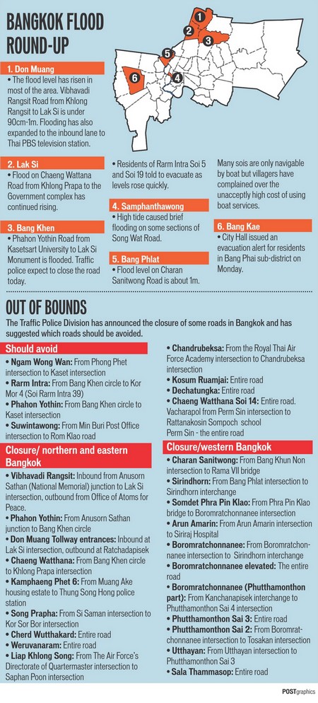
5.42 pm Safari World flooded: Floodwater entered the Safari World zoo in Klong Sam Wa district on Wednesday, forcing staff to move the animals to higher ground. Staff at the zoo, which occupies 430 rai of land on Ram Intra road, rushed to pump out water which had risen to 30cm high inside the grounds. The zoo announced it had closed for one day. (Bangkok Post)
0.33 pm Floodwater reaches Bang Chan Industrial Estate: Floodwater has reached Bangchan Industrial Estate in Bangkok's Min Buri district through the drainage system, reports said. (Bangkok Post)
12.00 am BMA puts emtire Bangkok on alert: No there is a heavy fight between Bangkok Governor Sukhumbhand Paribatra and Prime Minister Yingluck Shinawatra. The Governor will send council workers backed by police to repair the controversial Khlong Sam Wa sluice gate. Prime Minister Yingluck Shinawatra had ordered to widen the sluice gate to one metre. She took the action after nearby residents destroyed part of the sluice gate under the eye of police to speed up the drainage of their communities. The governor said he was using an order under the disaster prevention law which stipulates that he is the director of disaster management in Bangkok. It means he can send metropolitan police to Khlong Sam Wa sluice gate to maintain order and prevent further demolition. The penalty for defying the police and obstructing the workers is three months in jail and/or a 6,000 baht fine. MR Sukhumbhand said the gate might collapse if it was not repaired and that would cause massive flood damage to communities along Ram Intra and Ram Khamhaeng Road.
Meanwhile, Deputy Governor Thirachon Manomaipiboon said all 50 districts in Bangkok are at risk of flooding as a result of the Khlong Sam Wa incident. He said the first three districts in Bangkok that would likely face the incoming deluge are Bang Kapi, Saphan Sung and Bung Kum.
MR Sukhumbhand yesterday declared evacuation of the entire district of Bang Khen, Sena Niwet housing estate Project II, Jarakhae Bua sub-district of Lat Phrao district and Sam Wa Tawan Ok sub-district of Klong Sam Wa. Sai Kong Din and Kong Din Tai sub-districts of Klong Sam Wa and the entire district of Nong Chok have also been placed under close watch, he said. The governor said Bang Chan sub-district of Klong Sam Wa district is also under close watch and could be a flood risk area. He said he had received reports from the Flood Relief Operations Command (Froc) that it still could not close sluice gates at Khlong 8 and Khlong 10 because of fierce resistance from residents in nearby inundated communities. If the gates could not be closed, the flow of water will affect Nong Chok, Min Buri, Lat Krabang, Khlong Saen Saep and Khlong Lam Pathiew. (Bangkok Post)
1.11.2011:
3.01 am Flood levels in the west of Bangkok rising: Water in Thon Buri, Bang Plad, Thawee Wattana and Taling Chan remained high. Bang Khae was critical. Many main roads in western Bangkok such as Uttayan, Charan Sanitwong, Boromrajchonnee, Kanchanapisek, Suan Pak and Putthamonthon 1 and 3 were inundated.
The problem was the drain system in the west was not as good as in eastern Bangkok, Bangkok Governor said. Western Bangkok got water from Nonthaburi's Bang Kruay and Nakhon Pathom, he said. (The Nation)
31.10.2011
Graphic published by Bangkok Post 31.10.2011

People talking about situation in Bangkok West on thaivisa.com
08.01 pm Inner Bangkok passes danger point: GIS expert Dr Anond Snidvongs in a daily NBT flood analysis noted that innner Bangkok has passed danger point as today is the last day of high tide. Bangkok North sees reduced water volume at Khlong Rangsit, Bang Pa-in. Present flood in Laksi and Khlong Prapa resulted from leaks. Government is erecting new barrier at Lak Hok. There is no more danger from water mass from the North. In the next 3-4 days, high tide will be significantly less and government/BMA can drain even more water which will see flood level in Rangsit decline slowly. BMA tries to divert floodwater from Don Mueang and Phaholyothin through Khlong Lat Phrao and Saen Saep. Floodwater from Lak Si will be absorbed at Khlong Bang Khen and will not reach Chatuchak area. Government will try to protect Khlong Prapa from floodwater. Irrigation Department must finish all breached sluice gates/walls along Chao Phraya river so that all the flooded areas in Nonthaburi can be siphoned off to Chao Phraya river. This should be finished before Loy Kratong. If a few leaks in the North are fixed, Chaeng Wattana can be dry within one week.
Lat Krabang, Nong Chok, Minburi were originally planned as floodway to be drained off. But this no longer work as people settle there and object to rising water. To placate angry residents, the government decided to raise sluice gate at Khlong Samwa but this would pose threat to Khlong Saen Saep residents. Expect to see rising water in low-lying areas. But this would not pose threat to industrial estates. In the next few days, Froc has to be careful about Bangkok North and the west. The west still sees rising threat while the North and East pose less threat. (Bangkok Post)
11.00 am Taling Chan and Lak Si Districts under evacuation - warning for Bang Khae - better situation along Chao Phraya River: Bangkok Metropolitan Administration declared two more districts, Taling Chan and Lak Si Districts as the areas requiring evacuation since the areas of these two districts have been almost totally inundated with a trend of an increasing level. Bangkok Governor morover reports that today the level of the Chao Phraya River is recorded at 2.44 m. at the Mean Sea Level which is lower than predicted and also very lower than that of yesterday. Now it could be mentioned the influences of high tide has passed and could be expected again around the mid of November. Runoff from the north of Bangkok starts to remain stable as the level of water at Khlong Song. Meanwhile, the level at Khlong Rangsit is receding. After the receding at Khlong Rangsit, BMA will resume the repairing of the barrier where the Vibhavadi Road meets Khlong Rangsit since the repairing could not be done earlier due to the extremely high level of the flood. Bang Khae District requires close monitoring, says Bangkok Governor. He shared his concerns that the huge volume of the influx from the Bang Kruay District of Nonthaburi Province would be added with those volumes reversing their flow from Nakorn Pathom Province and thus will cause further damages. Now it was revealed that main roads on the western part of Bangkok begin to be inundated, i.e., Phutha Monthon Road, Kanjana Pisek Road, Boromrachacholnee Road. that since October 26 the mass volume of more than billion cubic meters of water has already passed through Bangkok, but we have to expect another more billions of the runoff. (BMA)
30.10.2011
Graphic published by Bangkok Post, 30.10.2011

11.00 pm Chim Plee, Taling Chan, Ramad Sub-Districts of the Taling Chan District under close watching: M.R. Sukhumbhand Paribatra, the Governor of Bangkok warns people residing in those areas should be readily prepared for an evacuation when necessary.
He adds Bangkok will have the highest tide at 10.21 am. The level of water of the Chao Phraya River at Pak Khlong Talad recorded at 2.53 m. causing flooding in the areas of Song Wad and Samsen 21 Road, Samsen 23 Road. The Governor reported that now almost 100 % of the area of Don Mueang District are completely inundated.
12.43 pm Taling Chan declared special watch zone: The Bangkok Metropolitan Administration has on Sunday declared the sub-districts of Chim Pli, Taling Chan and Bang Ramad in Bangkok’s Taling Chan district special watch flood zones. Bangkok governor Sukhumphand Paribatra said people living in those risk areas should prepare for evacuation anytime. The BMA also issued a warning for people living along the banks of Khlong Song, Khlong Thanon, Khlong Bangbua, Khlong Lat Phrao and Khlong Prem Prachakhon and nearby areas to move belongings to high ground. The BMA said people in these areas should prepare for possible flooding as the northern runoff is coming down from the upper part of the capital. /Bangkok Post)
12.06 pm Charoen Krung, Songwad roads flooded: The Charoen Krung road in Yan Nawa district of Bangkok is now under more than 50 centimetres deep water, reports said. The overflow also inundated Songwad road in Bangkok’s Sampantawong district, according to the reports. The water level was reported at 50-80 cms. (Bangkok Post)
29.10.2011
Water to be rationed west of Chao Phraya River: The Metropolitan Waterworks Authority has announced that it will need to lower the production output due to the ongoing flood. As a result, the water will be rationed in most of the Bangkok Greater Area west of the Chao Phraya River. The water will only run twice a day, from 6 AM to 9 AM and from 5 PM to 8 PM. This will be in effect in an extensive area west of the Chao Phraya River, including Pak Kret, Bang Bua Thong, Bang Yai, Sai Noi, Bang Kruai and Muang districts of Nonthaburi Province, Phra Pradaeng and Phra Samut Chedi districts of Samut Prakan Province and Thonburi, Khlong San, Bangkok Noi, Bangkok Yai, Taweewattana, Bang Phlat, Nong Khaem, Phasi Charoen, Taksin, Bang Bon, Thung Khru, Chom Thong, Rat Burana, Bang Khun Thian and Taling Chan districts of Bangkok.
The MWA will try to address the problem in order to reverse to the normal service as soon as possible. (tannetwork.tv)
High tides on Saturday morning: Feared flooding din't happen: There was some good news for central Bangkok this morning when the arrival of the first of the weekend’s high tides failed to result in the widespread flooding that some had feared. There has been some localized flooding in some streets near the Chao Phraya River and in the Thonburi district, but the flood defences have held up well so far and the majority of inner and central Bangkok remains dry. However, there is still no room for complacency with another high tide due this evening and another two tomorrow (Sunday) which will put more strain on the flood barriers as the level of the Chao Phraya River rises. It is being forecast by local authorities in Bangkok that the western side of the Chao Phraya River (Thonburi) will see the worst of any flooding over the next 48 hours with overspill from the Bangkok Noi canal adding to the problems on that side of the river. Wat Arun (Temple of the Dawn) is on the Thonburi side of the river, but at the time of writing, Bangkok resident Richard Barrow is there and says it is completely dry with no problems. (thaizer.com)
10.17 am PM: Flood will recede early November: The flood water inundating outer areas of Bangkok is expected to start receding in the first week of November, Prime Minister Yingluck Shinawatra said on Saturday morning. Ms Yingluck said Royal Irrigation Department has been assigned to rapidly drain the flood water out to the see through Khlong 6 to 13 in the eastern part. The Bangkok Metropolitan Administration and the Ministry of Natural Resources and Environment have been directed to drive the northern runoff out through Khlong San Sab, she added. In the western part of the capital, the Royal Irrigation Department and Ministry of Transport are responsible for draining the runoff from the North to the Gulf of Thailand through the Chao Phraya River and Tha Chin River, said the prime minister. (Bangkok Post)
12.00 am Big C: Drinking water arriving: The first shipment of imported drinking water from Malaysia will arrive in Bangkok today, according to a leading retailer. Big C Supercenter Plc is importing up to 45,000 1.5-litre bottles of drinking water to alleviate a serious shortage. An additional 30,000 bottles of mineral water will be available next Wednesday while another 90,000 bottles of drinking water are due by Nov 12. (Bangkok Post)
12.00 am All of Thon Buri faces inundation: The entire Thon Buri area is expected to be submerged within three days due to signs that northern runoff could overwhelm attempts by City Hall and irrigation officials to defend the western part of the Chao Phraya River. Chainat Niyomthoon, deputy director of the Bangkok Metropolitan Administration's Department of Drainage and Sewage, expected the water to eventually overflow several canals including Khlong Maha Sawat in Thawi Watthana district. Apart from Khlong Maha Sawat, the southern railway track, which runs parallel to the canal, is another barrier to prevent floodwaters going downstream. But Chaiyaporn Promsuwan, director of the Irrigation Office's Phra Pimol irrigation project, said the track, which is 3m above sea level, could be inundated and was unable to shield Thon Buri from flooding. "The southern track may not be able to withstand [the massive volume of floodwater] in the next two to three days. This will result in heavy flooding in Bangkok's Thon Buri and adjacent areas in Nakhon Pathom," Mr Chaiyaporn said. Meanwhile, the Flood Relief Operations Command last night said five locations have been set aside as gathering points for people leaving the areas. They are the Thailand-Japan Stadium in Din Daeng, Fashion Island on Rarm Intra Road, Holland Beer on Rama II Road, the Mall department store in Bang Khae and Wat Sri Iem in Bang Na. People should gather there before being sent to shelters, or transported to other provinces if they do not want to stay in Bangkok, Froc spokesman Thongthong Chandarangsu said.
12.00 am People sell gold for cash during flood: During the flood, apart from stocking up on food and water, people are keen to turn their gold into cash for emergencies. MTS Gold Futures chairman Kritcharat Hirunyasiri says: "Customers around Greater Bangkok are coming to our shops at either The Old Siam or Wong Wian Yai to sell their gold assets. They thought it best to keep cash instead of gold for emergencies," said Mr Kritcharat. (Bangkok Post)
28.10.2011
See video of Charoenkrung Road
2.51 pm Sukhumvit sois 48, 50 flooded: A section of a dyke along Phra Khanong canal has collapsed, releasing an enormous amount of water into Bangkok's Sukhumvit soi 48 and soi 50. Khlong Toey district chief Wiparat Chaiyanukit said on Friday the breach was about 10 metres long. Mrs Wiparat said about 50 soldiers and workers from the Department of Drainage and Sewerage were piling up sandbags to plug the opening in the dyke. The dyke should be repaired before high tide this evening, she said.
12.43 pm 14 city roads in Bangkok closed:
In northern Bangkok, the roads closed are:
1. Vibhavadi Rangsit: between National Memorial and Lak Si intersection;
2. Phahon Yothin: between National Memorial and Soi Phahon Yothin 50;
3. Khamphaeng Phet 6 (local road): between the entrance to Muang Ake housing estate to Thung Song Hong intersection;
4. Songprapa: between Sri Saman and Kor Sor Bor intersections;
5. Weluwanaram: the entire road;
6. Liap Khlong Song: between Air Force Palathikarn and Sapan Poon intersections;
7. Chantharubeksa: between Air Force Academy and Chantharubeksa intersections.
In western Bangkok:
8. Charan Sanitwong: between Bang Phlad intersection and Sirindhorn interchange;
9. Arun Amarin: between Arun Amarin intersection and Sirindhorn elevated road;
10. Boromratchachonnani:between Pin Klao bridge and Sirindhorn elevated road;
11. Boromratchachonnani:between Phutthamonthon 3 and Phutthamonthon 4 intersections;
12. Sirindhorn: between Bang Phlat intersection and Sirindhorn elevated road;
13. Uthayan: between Uthayan and Phutthamonthon 3 intersections; and
14. Sala Thammasop: the entire road. (Bangkok Post)
12.01 pm Chao Phraya water level hits new high: The water level of the Chao Phraya river was measured at 2.47 metres above mean sea level this morning, Bangkok Governor Sukhumbhand Paribatra said Friday. The governor said he agreed with the government's Flood Relief Operations Centre's plan to dig channels across five major roads in an attempt to improve the flow of the massive volume of floodwater bearing down on the capital's inner areas out to sea. The roads are Pracha Ruam Jai, Rat Uthit Road, Suwinthawong Road, Nimitr Mai Road and Ruam Phattana Road.
12.00 am Plan to cut channels into streets to let flood off: The Flood Relief Operations Command (Froc) is looking at the possibility of digging channels into some roads in eastern Bangkok to help drain runoff from the north to the east of the capital and on to the sea. The roads are Pracha Ruam Jai, Rat Uthit Road, Suwinthawong Road, Nimitr Mai Road and Ruam Phattana Road. The roads have blocked the runoff from reaching the areas where the water pumps are installed.
Graphic published by Bangkok Post 28.10.2011

27.10.2011
6.48 pm BMA: Evacuate Thawi Watthana: The Bangkok Metropolitan Administration (BMA) on Thursday evening issued an announcement advising the people in Sala Thammasop area of Thawi Watthana district to evacuate to safe areas as the water level is rising alarmingly there.
04.00 pm Governor: All Bangkok won't flood: Not all districts in the capital will be flooded, Bangkok Governor Sukhumbhand Paribatra said Thursday. "As the person in charge of Bangkok, I believe that the water will not flood every district of Bangkok and some districts might not be inundated,". But he said also: "We are considering, whether we should order an evacuation of Tawee Wattana district as the flood situation there is worrying," the governor said after more water surged into Tawee Wattana canal. (Bangkok Post)
3.38 pm BTS: Skytrain will keep running: The Bangkok Transit System Co, operator of the elevated skytrain, said on Thursday it has no plans suspend services during the flooding.
12.00 am More districts evacuated - Chao Phraya to peak at 6pm on Saturday: Floods have become more widespread in many parts of Bangkok and residents in Don Muang, Bang Phlad and Thawi Wattana districts have been urged to evacuate to safety immediately. Bangkok governor MR Sukhumbhand Paribatra said 90% of Don Muang district has already been submerged by rising floodwaters, 70 % of Bang Phlad district now under high levels of water. He added that two more districts - Wang Thong Lang and Lat Phrao - are now under close watch. Thawi Wattana district chief Prapat Thirapongthorn said the flood situation in the district is worsening as a substantial volume of floodwater from Nonthaburi and Pathum Thani is flowing into the Chao Phraya River, which breached its banks, inundating riverside and canalside communities. Residents along riverbanks and on the banks of Khlong Maha Sawat are urged to leave immediately, Mr Prapat said, adding the overflow will continue to rise further in the next few days. Vice-Admiral Nirut Hongprasit, director-general of the Royal Thai Navy's Hydrographic Department, said the Chao Phraya River's water level is predicted to reach its peak at 2.65m after 6pm on Saturday. The peak level should last no more than 30 minutes, he said. (Bangkok Post)
5.00 am Bangkok flood worsened: As of Thursday morning, the floodwater was continuing to rise in northern and western Bangkok. On Vibhavadi-Rangsit Highway, the inundation had spread to Wat Lak Si, located about 200 metres from the Don Muang Tollway ramp. The water level was about 50 centimetres high. On Phaholyothin Road, the floodwater from Future Park Rangsit shopping mall to Don Mueang Airport also continued to rise, shutting down traffic.
The overflowing water had also started to inundate Bhumibol Hospital. A section of earth dyke at Don Mueang Airport collapsed, prompting emergency pumping in order to safeguard the headquarters of Flood Relief Operations Centre. In Thon Buri, workers were unable to complete the repairs of dykes at two major canals, Masawat and Thawi Wattana, due to the strong water flow. The inundation at Wat Puranawas rose to 2.4 metres (The Nation)
26.10.2011
Graphic published by Bangkok Post 26.10.2011

6.42 pm Heavy flooding in Don Mueang area - seven roads closed: Police closed seven city roads to traffic after Vibhavadi-Rangsit and Phahon Yothin highways were heavily flooded and declared impassable for small vehicles on Wednesday. Floodwater inundated Vibhavadi-Rangsit highway from the Lat Phrao intersection to in front of Don Mueang airport. The water level in front of Wat Don Mueang was about 50 centimetres. On Phahon Yothin Road, floodwater had reached Saphan Mai area and the water level continued to rise. The polcie closed seven roads:
. Vibhavadi Rangsit road from the National Memorial to Lak Si intersection;
. Phahon Yothin road from the National Memorial to Saphan Mai area;
- Khamphaeng Phet 6 road from Rangsit to Don Mueang railway station;
- Songprapha road from Wat Sikan intersection to Pracha Uthis intersection;
- Weluwanaram road to Soi Chaeng Wattana 14;
- Charan Sanitwong road between Sois 72-84 (in-bound) and Charan Sanitwong road between sois 75/1-89 (out-bound);
- Sirindhorn road from Sirinthorn interchange to Soi Sirindhorn 2 (inbound) and from Soi Sirindhorn 7 to Sirindhorn interchange (outbound). (Bangkok Post)
Bangkok Governor: All 50 districts must brace for flood: Bangkok governor Sukhumbhand Paribatra on Wednesday warned city dwellers in all 50 districts to brace for flooding as a significant portion of the backed up floodwater from the North is arriving the capital tonight. The governor said he has instructed all 50 districts to be prepared for flooding and expressed concern for 13 specially at-risk areas along the Chao Phraya River, as well as districts in northern and eastern Bangkok, including Lad Krabang, Nong Chok, Min Buri, Khlong Sam Wa, Khan Na Yao, Bang Khen, Sai Mai, Don Mueang, Chatuchak, and Bang Sue. City Hall will assess the situation again this evening before announcing whether it will declare further warnings for other areas, according to the governor. (mcot.net)
12.00 am PM says floodwalls not able to withstand water: The prime minister conceded existing floodwalls and water embankments might not be able to withstand the massive inundation and said there was a strong chance the flood will penetrate central and inner zones of the capital. "The highest risk will be areas along the Chao Phraya River and the floodwalls along the banks. The flood level will depend on how well we can manage the water flow," Ms Yingluck said in a televised message.
BMA workers are working despite public holiday: Thailands government has announced a five-day public holiday from October 27-31. Bangkok Governor confirms now, that workers of Bangkok Metropolitan Administration (BMA) are working November 27 and 28 and 31 - to fight the flood.
25.10.2011
Graphic piublished by Bangkok Post 25.10.2011:

Chao Phraya River barriers collapsed at the Pin Klao area in Thon Buri on Monday, closing major Bangkok roads on the west side of the river.
04.01 pm Don Mueang airport closed: Airports of Thailand Co (AoT) has declared the closure of Don Mueang airport from 7pm today as the flood has reached runways and affected the lighting. Earlier today low-cost airline Nok Air, which operates flights to provinces from Don Mueang airport, announced the suspension of its air services from noon today.
Orient Thai, another low-cost airline, has moved its flight base from Don Mueang to Suvarnabhumi airport, from 3pm today until further notice. (Bangkok Post)
1.32 pm Bangkok in 'flood crisis mode': Bangkok's second airport shut down Tuesday as floodwaters advanced into the Thai capital, forcing authorities in "crisis mode" to declare a five-day public holiday in preparation for the deluge. The cabinet ordered an October 27-31 holiday for Bangkok and 20 other provinces affected by the kingdom's worst flooding in decades. In a televised address to the kingdom late Tuesday, Prime Minister Yingluck Shinawatra said it was "highly likely" that all of Bangkok, including the inner zone, would flood, with a "worst case scenario" seeing water levels of up to 1.5 metres in some parts. (Bangkok Post)
01.02 pm Urgent evacuation: Muang Ake: Residents of Muang Ake housing estate and surrounding communities should evacuate urgently because the floodwall at Lak Hok in Pathum Thani has broken, causing water to flow into the area, the Flood Relief Operations Centre (Froc) announced on Tuesday. The area was expected to come under 1 - 1.5 metres of water. (Bangkok Post)
12.00 am Efforts to drive water to east, west of Bangkok fail: About 4,000 million cubic metres of flood water from Ayutthaya is expected to reach Bangkok tomorrow, Deputy Bangkok Governor Pornthep Techapaiboon said yesterday. "The problem is City Hall can drain no more than 400 million cu m of water a day," Mr Pornthep said. The huge water mass will enter the west of Bangkok via Nakhon Pathom, Nonthaburi and sweep into Khlong Thawi Watthana, Khlong Bangkok Noi and Khlong Bang Phlad and is expected to reach up to three metres high. However, Mr Pornthep said there is a 2.7-metre-high railway track in Thawi Watthana district which serves as a flood barrier in the west of Bangkok.
Chao Phraya river breached its banks and inundated riverside communities in Bang Phlad, Samsen and Charan Sanitwong.
Prime Minister Yingluck Shinawatra yesterday said that Bangkok has seen floodwaters converge on it from various directions.
Prime Minister Yingluck Shinawatra yesterday said runoff from the north has reached the north of Bangkok because the Royal Irrigation Department (RID) could not close the Khlong 1 sluice gate in Rangsit as the water flow was too strong and high. She added that areas from the Chulalongkorn sluice gate down to Sai Mai district are at risk of floods despite efforts to divert waterflow to the east of Bangkok.
Ms Yingluck said that in the west of Bangkok, three more drainage canals in Nakhon Pathom have been dug and dredged to help divert run-off to the Tha Chin River and on to the sea. They are Khlong Ngiew Rai in Nakhon Chaisi district, Khlong Song Khanong and Khlong Thakham in Sampran district. But a problem had arisen as no water had flowed into the canals so far, probably because areas around the canals are flat and even. But it is hoped that the massive flow of runoff will soon surge forward into the canals, she said. (Bangkok Post)
11.30 am Governors warning: Chao Phraya River expected over the height of the water barrier: M.R. Sukhumbhand Paribatra, the Governor of Bangkok: with reference to the forecasted level of high tide for today the level at the River could be expected at 2.35 – 2.40 m. which is over the maximum height of the water barrier along the River. BMA, hence, instructs those residing along the River and all connecting passages of water from the River to pay extraordinary cautions to the situation and be prepared to move their valuable belongings including electrical outlets to safe locations.
Khlong Prapa has returned to normalcy. The Lak Si District has been cleared of the flood whereas the Don Mueang District still is being affected. Khlong Tawee Watana recorded a rising level of 12 cm. With more opening at the gate, Khlong Prem Prachakorn still recorded an increase of more than 5 cm. , however, the flood is pushed into Khlong Lad Prao.
At the intersction of Vibhavadi Road with Khlong Rangsit the construction of sand bag barrier could not stop influx of the flood. BMA therefore further attempts by constructing new line of barriers at Khlong Song, Chandharubeksa Road, the Air Forces Headquarters and another connecting segment of the Vibhavadi Road to allow an access to the Flood Relief Operation Center.
1.08 am Mega waves still to come: Bangkok faces the threat of two huge masses of water northeast of the city over coming days, a senior Royal Irrigation Department official warned yesterday. "The first mass of water has left Rangsit canal briming, and spilling over the parallel Rangsit-Nakhon Nayok road [running in an east-west direction] north of Bangkok, which doubles as a flood barrier," said the official. The second mass of water, now trapped further north beyond the Klong Luang road in Pathum Thani [which also runs east-west], was also building, and would soon cross the road to add to the first, he explained. "When these two lots [of water] combine, in the next few days, they will amass and break through barriers along Rangsit-Nakhon Nayok road and head to further inundate Lak Luk Ka district in Pathum Thani, then Don Muang in northern Bangkok," he said. "The first lot is already inundating areas near Klong 1, 2 and 3 on the Phaholyothin Road side, but the Klong Luang road cannot hold the second lot for much longer."
Bangkok residents are advised to stockpile tapwater. (The Nation)
24.10.2011
Graphic published by Bangkok Post 24.10.2011:

11.12 pm The worst case Scenario for Bangkok: Dr Seri Suprathit, a water expert, said von TV: If all the government's flood defence walls including those protecting inner Bangkok were breached, the flood will come as follows: Bangkok North such as Sai Mai, Laksi, Don Mueang, Chatuchak will see about 30-50 cm water deep and people can live and move about. Those outside the protected walls and those areas in Bangkok South will see the flood water as high as chest deep especially along the Chao Phraya river. (Bangkok Post)
7.30 pm Chao Phraya River in Bangkok now at 2.30 m - record: The old record of 16 years ago was at 2.27 m. People residing along the Chao Phraya River "are in somewhat risky situation", warns Bangkok Governor. The flood along Viphavadi Road has spread out. (Announcement of Bangkok Governor)
12.00 am Govt makes barriers off-limits. Public prohibited from interfering in relief work: The government has declared water gates and flood barriers special control zones as it struggles not only with the disaster but also with interference from protesting affected residents. Prime Minister Yingluck Shinawatra ordered the closure of Phra-in Racha sluice gate in Khlong Raphipat in Bang Pa-in district of Ayutthaya province, adjacent to Khlong 1 in Khlong Luang district of Pathum Thani yesterday. The order came after week-long opposition from locals. The failure to close the sluice gate sent floodwater from Wang Noi district of Ayutthaya through Khlong 1 to Rangsit in Pathum Thani and further to Khlong Prem Prachakorn, which flows down to Bangkok. See picture of a two-metre-long crocodile captured in flooded Cholada housing estate in Nonthaburi's Bang Bua Thong district. (Bangkok Post)
11.32 am Bangkok braces for unstoppable flood waters. Another major test is expected between October 28 and 30 when seasonal high tides flow up Bangkok's Chao Phraya river, meeting run-off water from the north. (Bangkok Post)
11.16 am BMA: Flood warning for six districts: Bangkok Metropolitan Administration late Sunday night issued a warning for people in six districts to prepare for flooding as the huge flow of foodwater from the North continues its creep into the capital. The six districts are Don Mueang, Lasksi, Bang Khen, Chatuchak, Bang Sue and Sai Mai. So the by popular Chatuchak Weekend Markt is converned too. (Bangkok Post). Bangkok Governor warned, that "a rather serious upcoming is very imminent and inevitable (...) BMA will further assess the situation for the other surrounding districts tomorrow (...) BMA has relayed this message to the Permanent - Secretary of the Ministry of Foreign Affairs to instruct the embassies, the residences of ambassadors and diplomatic corps locating and residing in those mentioned areas". read the full warning text
Bangkok Governor writes also: "Unfortunately the water overflowed Khlong Prem Prachakorn and rushed to the areas of Don Mueang District inevitably affecting the inner areas of Bangkok. The eastern parts of Bangkok remain inundated with some problems at the Bang Plad District." The Governor stressed that if the flood influxes into the city, the overall situation could turn very critical and BMA will inform the public 24 hours in advance. BMA is determined to maintain the accessibility to the Don Mueang
International Airport. Read the Governors message
23.10.2011
23.10.11, 12 am: This graphic has been published by Bangkok Post:

12.00 am Army push to save Lat Krabang and Bang Chan industrial estates:
12.00 am Deluge reaches city's north: Flooding broke out across northern Bangkok yesterday as floodwaters from Ayutthaya and Pathum Thani stressed canals and flood barriers across the city. Bangkok has been mostly spared from the floods to date. But this can change. Seree Supharatid, director of the Disaster Warning Centre at Rangsit University predicted widespread flooding within the next four to five days, as water from Nonthaburi's Sai Noi and Bang Bua Thong districts race through Taling Chan on the Thon Buri side of the city. Froc yesterday warned residents in Thon Buri and Nakhon Pathom's Phuttamonthon to brace for flooding in the next few days. Rangsit-Nakhon Nayok highway was closed as floodwaters rose to as high as one metre, forcing motorists entering the capital from the north to use Vibhavadi Rangsit Road or the Don Muang tollway. In Don Muang, water levels were reported at 30 to 40cm along Songprapa Road to the Pracha Uthit intersection. On Nawongpattana Road, running to Songprapa, floodwaters reached as high 50cm, impassible for most small cars. On Phahon Yothin Road, near the National Memorial and Thupatemee Stadium, water reached 30cm. A sandbag barrier erected along the Chao Phraya in Samsen gave way, leading to minor flooding near the Bang Krabue intersection. (Bangkok Post)
22.10.2011
 Picture by Philip Roeland
Pakkret in Nonthaburi on 22.10.2011
 Picture by Philip Roeland
Chaeng Wattana Road on 22.10.2011
A blog about inner Bangkok. Peter Keusgen writes: Bangkok flood waters rising
12.32 pm Thai PM warns deadly floods to last weeks more: "Bangkok must open all floodgates to allow the water through," said Yingluck. "So during this long weekend residents should move belongings, cars and other valuable things to places at least one metre high."
Three months of heavy monsoon rains have killed at least 356 people in Thailand and damaged the homes and livelihoods of nine million people, mostly in the north and centre, the government said.
In Bangkok, home to 12 million people, residents have rushed to stock up on food and bottled water, while motorists have parked hundreds of cars on bridges or elevated roads. (Bangkok Post)
7.20 pm King Mongkut university flooded: The flood water has breached the dyke and immediately flooded Pibulsongkram Rd, North of Bangkok and in a few hours flooded King Mongkut Technology University North Bangkok (Thai-German). (Bangkok Post)
5.31 pm Thammasat University in Rangsit, Bangkok Under Water: According to Thai TV News Thammasat University, the Rangsit campus, is starting to flood. (tastythailand.com). Rangsit Campus moves flood victims to second floor as dyke is breached. Water had reached about 30cm in front of the shelter and was expected to rise to one metre. The floodwater burst into the university through a compromised dyke at the Asian Institute of Technology (AIT) next door. (Bangkok Post)
8.09 am Bangkok governor orders evacuations of residents of 27 communities along Chhao Phraya River: Bangkok Governor Sukhumbhand Paribatra Saturday issued a warning for residents of 27 communities along Chao Phya River to evacuate immediately. (The Nation)
Concerned are: Map of the 27 communities. Text of Announcement in Thai. A rapid and unexpected rise of the Chao Phraya River up to the level of 2.40 m. was recorded. The consequences are flooding in the areas of 5 districts, namely, Dusit, Pranakorn, Sampanthawong, Bang Plad and Bangkok Noi. The high tide of the river would be around 4.00 pm. tomorrow so BMA strongly urges those living outside the barrier along the river (about 1,200 households) to move to the centers of flood relief operation of each district. Read more
8.05 am Sam Sen Road inundated after swollen Chao Phaya breaches dyke: The Sam Sen Road was inundated by about 40 centimetres deep Saturday after the swollen Chao Phya breached a dyke at Kheawhai Ka Pier at Bang Kra Bue intersection. (The Nation)
12.00 am Biggest challenge yet to come: Post Today interviewed Science and Technology Plodprasop Suraswadi about the government's flood management efforts at the Flood Relief Operations Command. About 20 billion cubic metres has fallen this rainy season, and [by Wednesday] the government was able to drain about 8 billion cubic metres into the sea. At least 10 billion cubic metres have yet to be drained.
About the mistakes: The first mistake was the retention of too much water in Bhumiphol and Sirikit dams. The second factor was the rainy season came one and a half month earlier than normal. The third factor was this year's rainy season has lasted a long time. The amount of rainfall this year is about 30-45% greater than the annual average. The second mistake was when the huge amount of water which was released reached Chai Nat. If we had known it would rain so heavily, we would have directed the waterflow to the west of the Chao Phraya River via Pholthep water gate. The only option for us now is to direct the water to the east of Bangkok along several canals. Right now the government can propel the water into the sea through all channels at the rate of about 400-500 million cubic metres a day. There are still 10 billion cubic metres, which will take about 20 more days to drain.
How much will outer Bangkok suffer? It depends on each area's topology. If it is a low-lying area, the water can be 1-2 metres deep. If it is higher, the water may be only 50cm deep. Inner Bangkok is safe, but where? The inner area surrounded by flood prevention barriers. (Bangkok Post)
12.00 am Relief effort falters in Bang Bua Thong: Officials and rescue workers trying to help flood victims trapped in Nonthaburi's Bang Bua Thong district have been struggling to carry out their tasks. A shortage of boats with engines has been a significant obstacle. With almost the whole of Bang Bua Thong district inundated, the flood level near Thanon Canal in Bang Yai district, adjacent to Bua Thong 1 housing estate, has risen to over one metre. Areas on both sides of Kanchanaphisek Road (Taling Chan-Suphan Buri) in front of Bang Yai Market are also flooded. (Bangkok Post)
11.41 am Flood arrives at Thupatemee stadium: The floodwater on Saturday morning flow to inundate the Tupatemee stadium of the Royal Thai Air Force in Don Meuang (Bangkok Post)
3.08 am Flood-related tunes: A little moist music. Every time there's flooding in Thailand, the old song "Nam Thuam" ("Flood") works its way back into heavy rotation on radio, and it's the oft-heard soundtrack to TV-news scenes of the watery disaster. See and listen: Nam thuam - Album Huajai Lookthung 2
1.02 am Market cleared, estate evacuated, trains disrupted: Pathum Thani and Nonthaburi are heavily submerged after flood water rages through Prapa canal and continues to rise. After days of struggling with flood prevention supported by 4.5metre flood barriers, Bang Kadee industrial estate in Pathum Thani has been submerged, with damage to all 47 factories estimated at Bt30 billion. Panic reigned at Rangsit market which is under 1metre of flood water and evacuation is underway by most vendors and residents who did not expect it. Flood water is spilling over the Chulalongkorn floodgate in addition to a huge influx travelling southward through Prapa canal.
Rangsit-Chiang Rak trains have been suspended due to flooding and an extra shorterdistance service is available. All 18 northbound longdistance trains are suspended while all 12 northeastbound trains can travel using bypass routes to Chachoengsao, said the government Flood Relief Operations Centre citing a State Railways of Thailand statement. All commuters must board the trains at Hua Lamphong terminal in Bangkok. (The Nation)
21.10.2011
Comment of this blog: Prime Minister Yingluck Shinawatra on Friday issued a disaster warning for Bangkok. But the disaster hasn't arrived in inner Bangkok until now. For the moment, there are not more flood warnings by the Bangkok Governor as yesterday. The drainage of water through the canals of Bangkok seems to work quite well for the moment. Suvarnabhumi Airport remains unflooded and open. International media, who write, that Bangkok has lost the fight against flood, are wrong. But districts in the north of Bangkok are hit hardly.
See pictures from Bang Bua Thong
09.28 pm Flood has yet to arrive at Lak Si (East Bangkok): According to the latest Pantip.com flood web report, users post that Lak Si has yet to see any flood water. However, Muangthong Thani is now flooded at no more than 20 cm due to the earlier Khlong Prapa Pakkret dyke destruction by residents on Don Mueang side whose homes are flooded due to no dyke construction on that side of the canal. (Bangkok Post)
8.15 pm Floods at Bangkok's gates but don't cancel your trip: Stuart writes von travelfish.org: Suvarnabhumi Airport remains unflooded and open -- as do the main transport links into downtown Bangkok. Central Bangkok remains largely unaffected.
7.10 pm Flood water reaches Zear, Rangsit: Flood water arrives at Zear shopping centre in Rangsit. (Bangkok Post)
06.19 pm Flood rises in Nonthaburi’s Bang Yai: Flood levels in Nonthaburi's Bang Yai district continue to rise as rescue workers trying to help people trapped in flooded Bang Bua Thong district report difficulties getting into areas where the floodwater is highest. Almost all of Bang Bua Thong district has been inundated, reports said. The flood level near Khlong Thanon canal in Bang Yai district, adjacent to Bua Thong 1 housing estate, had risen to over one metre. (Bangkok Post)
5.08 pm Disaster warning issued for Bangkok - but not more floods right now: Prime Minister Yingluck Shinawatra on Friday issued a disaster warning for Bangkok, consolidating power for flood control and drainage. Yingluck invoked the 2007 Disaster Prevention and Mitigation Act to oversee flood control in lieu of declaring a state of emergency. Under her instructions, the topmost priority for flood control is to speed up the drainage of run-off into the sea via East Bangkok. The government is to coordinate with the Bangkok Metropolitan Administration to operate all sluice gates in the capital in order to rein in the water flow. The armed forces would be in charge of maintaining and defending the royal-initiated dykes and levees. (The Nation)
The military would also be responsible for protecting key installations, including the Grand Palace, Siriraj Hospital, the tap water system, Suvarnabhumi and Don Mueang airports.
2.13 pm Khlong Prapa overflows bank: Khlong Prapa has burst its bank on the Bangkok side, flooding several housing estates in Don Mueang and overflowing onto Chaengwattana Rd with the level about 30cm. Small cars can still use Chaengwattana Rd on the Bangkok side, but slowly. (Bangkok Post)
12.00 am Flood crisis alters property landscape: Flooding will be a factor in the purchase of both new and resale residential units. (Bangkok Post)
5.08 am Plans to let capital flood ruled out: "The situation does not warrant flooding all of Bangkok because the water can still be diverted via the capital's eastern areas," Flood Relief Operations Centre (FROC) director Pracha Promnok said yesterday. He added that the water could flow through the city's three main canals, Saen Saep, Prawet and Phra Khanong. Sluice gates on the eastern outskirts were put in operation from Wednesday to divert water to the three canals under a timetable designed to minimise the chances of flash floods, he said. He voiced optimism that overland flow and runoffs from the north of the city would not inundate inner Bangkok. (The Nation)
2.08 am Deluge surprises Bang Bua Thong: Bang Bua Thong district was caught off guard when the flood surged into Nonthaburi early yesterday, leaving thousands of residents stranded in their homes without enough food and waiting impatiently for assistance. The flood water averages 1.5 metres in most areas, which are now accessible only by boats and military trucks.
The escape of flood victims to schools and temples has been disorderly, as evacuation plans were not activated. (The Nation)
2.01 am Plans to let capital flood ruled out: "The situation does not warrant flooding all of Bangkok because the water can still be diverted via the capital's eastern areas," Flood Relief Operations Centre (FROC) director Pracha Promnok said yesterday. He added that the water could flow through the city's three main canals, Saen Saep, Prawet and Phra Khanong. He voiced optimism that overland flow and runoffs from the north of the city would not inundate inner Bangkok.
12.00 am Bangkok districts told to brace: City Hall agrees to open up canals for drainage . The Bangkok Metropolitan Administration has agreed to help drain northern runoff into the sea through the city's canals. Bangkok Governor MR Sukhumbhand Paribatra last night issued a flood warning to residents in Thung Si Kan and Don Muang subdistricts in Don Muang district and Thung Song Hong subdistrict in Laksi district. He advised people in the three subdistricts to take shelter at Wat Donmuang, Prachautid, Wat Welu Wanaram, Bumrungrawiwanwittaya, Prempracha, and Phahon Yothin schools in Don Muang and Tungsonghong Witthaya, Bangkhen, Kehatungsonghong Witthaya, Wat Laksi and Kankahathasai schools in Laksi. He said water was overflowing along Khlong Prapa and leaked in barriers in Laksi. The announcement came hours after City Hall and the goverment agreed to a plan to drain the northern runoff through Bangkok's canals. (Bangkok Post)
 Picture by Remko Tanis
Resident of Nonthaburi, helping to fill sandbags, have a luttle break for their food.
 Picture by Philip Roeland
The flood situation in Pakkret Area in Nonthaburi
20.10.2011
12.00 am Sukhumbhand shows he's in charge of city. Bangkok Governor Sukhumbhand Paribatra (Democrat Party) and Prime Minister Yingluck Shinawatra (Pheu Thai Party) are headed in different directions regarding the way both have been handling the flood crisis. MR Sukhumbhand has shown his management skills by effectively mobilising all units under the Bangkok Metropolitan Administration to fend off floodwaters flowing downstream of the Chao Phraya River. The lacklustre performance of Ms Yingluck brings into question her leadership and this crisis of faith in the prime minister is growing. (Bangkok Post)
12.00 am Govt sacrifices eastern Bangkok: In a bid to save the economic heart of the capital amid surging water levels, the government has finally opted to use the eastern part of Bangkok to drain massive amounts of floodwaters from the northern outskirts. The drainage of floodwaters through eastern Bangkok will affect seven of its districts, namely Sai Mai, Klong Sam Wa, Kannayao, Min Buri, Lat Krabang, Bang Khen and Nong Chok. Information and Communication Technology Minister Anudith Nakornthap yesterday said the government has to save the heart of Bangkok which is densely populated and housed important economic areas.
Chalit Damrongsak, director-general of the Irrigation Department, reported that floodwaters from Ayutthaya and Pathum Thani were flowing at 120 million cubic metres per second to eastern Bangkok, 100 million cu m/s to western Bangkok and 480 million cu m/s from 300,000 rai of fields from the Raphiphat canal to the Rangsit Prayoonsak canal north of Bangkok.
More than 8 billion cu m of floodwaters are flowing from Ayutthaya and Pathum Thani towards Bangkok.
The Chao Phraya River discharges less than 200 million cu m/day while attempts to divert floodwater via the east and west of the capital can drain only about 86 million cu m daily.
The government also wants to drain floodwaters through three canals in inner Bangkok, namely the Song Ton Noon, Saen Saep and Prawet canals. (Bangkok Post)
Bangkok Post has published this graphic:

12.00 am All Nonthaburi districts inundated: Bang Bua Thong and Pak Kret districts being the worst hit. In Bang Bua Thong district, runoff punched through water gates at Khlong Ta Chom and Khlong Rongkrajom in tambon Pimonrat, causing floodwater to surge into several housing estates. In Tambon Bang Bua Thong, all except four villages are under flood water.
Tambon Bang Khurad was prompted to issue a flood warning as the flood wall at Khlong Toh Rong Mai was being reinforced.
A road passing tambon Pimonrat and tambon Bang Khurad is the only way to reach the main road to Bangkok.
In Pak Kret district, also in Pathum Thani, a three-metre rupture at the earthen flood dyke at Wat Phothong Bon in tambon Ban Mai sparked panic. More than 100 people and officials rushed to repair the wall with sandbags.
In Pathum Thani's tambon Bang Kadi, troops built a flood wall from sandbags to prevent the flood water from pouring into Bang Kadi industrial estate. (Bangkok Post)
3.01 am Deluge heading to Rangsit. Governor warns run-offs from North coming towards capital faster than expected. The flood is expected to surge into Canal 2 and Hok Wa Canal, the frontline defence of the capital, tomorrow.
Bangkok Flood 2011? Bangkok still Dry: Jewie reasoning in his blog
19.10.2011
Singaporeans warned: Delay travel to Bangkok in the next days (Channelnewsasia)
6.22 pm Truth & the floods: The mighty river & its floodwaters makes it difficult for politicians to maintain a good image with lies. "As the nation reels from the worst floods in decades that have ravaged businesses and damaged the livelihoods of millions of people, it appears the public is being kept in the dark by a government which believes that telling the truth might backfire", writes Amornrat Mahitthirook in Bangkok Post.
4.06 pm Evacuation: Khlong Hok Wa. City Hall has advised residents of over 200 households outside Bangkok's floodwalls along Khlong Hok Wa canal in Sai Mai district to evacuate to two temporary shelters. (Bangkok Post)
03.35 pm Kittiratt: Workers won’t lose jobs: People working at the flooded factories will not lose their jobs and will still get monthly income from the Social Security Fund, Commerce Minister Kittiratt Na-Ranong said on Wednesday. He said he had discussed ways to help ease the hardship of people with loan repayments to meet with commercial banks. It was confirmed that the banks would come up with assistance measures, including offering a moratorium and lower loan rates during the reconstruction period.
2.09 pm Living through Bangkok's floods: A personal report from Bang Bua Thong.
2.01 pm Nava Nakorn Industrial Estate abandoned to flood: The attempt by workers and authorities to save flooded Nava Nakorn Industrial Park in Pathum Thani has been called off because water on the Phahon Yothin highway continues to rise. (Bangkok Post)
12.00 am Race begins to defend the capital. Sai Mai turns into a strategic battleground: The Bangkok Metropolitan Administration (BMA) is defending the eastern part of the capital by speeding up reinforcement of flood barriers in Sai Mai district. Sai Mai has become a strategic battleground for City Hall as failure to stop flooding there could see some northern and eastern districts close to inner Bangkok such as Don Muang, Bang Khen, Bang Kapi and Min Buri under water and inflict damage to the capital.
(Bangkok Post)
Map published by Bangkok Post:

5.08 am Seven Bangkok districts at risk of flooding:
Bangkok Governor Sukhumbhand Paribatra Wednesday warned residents of seven districts to prepare themselves for possible flooding. Sukhumbhand said Sai Mai, Bang Khen, Klong Samwa, Nong Chok, Min Buri and Lat Krabang could be flooded after the Klong Song, Klong Si, Klong Ha and Klong Hok sluice gates were opened to let upstream water into the Rangsit Canal. (The Nation)
5.01 am Thousands may be left jobless: The inundation of 14,172 factories and businesses in 20 provinces has adversely affected 663,218 workers, Arthit Isamo, director-general of the Labour Protection and Welfare Department, said yesterday. Severe flooding in Pathum Thani forced 3,326 factories to close, leaving 218,474 workers out of work, he said citing reports released at noon yesterday.
2.07 am City fate rests on barriers: The 6-kilometre flood barriers along the Hok Wa Canal, for example, will have to be 50 centimetres higher, to 3 metres. The BMA plans to increase the height by using 1.2 million sandbags. The BMA will also rush to build a 3-metre-high floodwall along the 15km Prachasamran Road, besides other measures. (The Nation)
Graphic published by The Nation:

2.06 am Suvarnabhumi dykes heightened to 4 metres: The Suvarnabhumi International Airport Wednesday heightened its earthen dykes to four-meter-high and piled up one-meter-high sandbag barriers along surrounding roads, in a bid to prevent flood. (The Nation)
18.10.2011
8.32 pm Flood barriers to be ready in time: In a live telecast, BMA governor MR Sukhumphan Boriphat assures the viewers that BMA has time until 21.00 tomorrow night to finish all flood barriers when the mass of water expected to attack Bangkok North. (Bangkok Post)
05.59 pm In Nonthaburi, a water gate in Bang Bua Thong district collapsed this afternoon, allowing a large amount of water to flow into nearby communities. The flood reached Bang Bua Thong fresh market and many houses in the area. Nonthaburi's Pakkret district chief Wisit Puangphet said residents in three communities - tambon Khlong Phra Udom, tambon Bang Tanai and tambon Khlong Khoi - were asked to immediately move their belongings to higher ground as floodwaters in their communities rose sharply. The three communities were flooded after a huge volume of water from Pathum Thani province early today destroyed several embankments of sandbags built by the district to block the overflow from the Chao Phraya River. (Bangkok Post). Read more: 3 Pak Kret districts put on alert
04.10 pm Bang Kradi industrial estate threatened by flood
03.15 pm Economic cost of flooding (Bangkok Post). Read more: Cost of deluge estimated to be 'massive'. Govt looking to borrow heavily from overseas
02.36 pm Flood warning near Suvarnabhumi: The Royal Irrigation Department has warned people living outside Bangkok's northern floodwalls, east of King Kaew and Rom Klao roads, to move their belongings to higher ground as those areas are expected to be flooded. Floodwaters in those areas were expected to be 50-80 cm high and residents should move their belongings to safer places or build embankments of sandbags in front of their houses to a height of at least one to 1.5 metres. The deaprtment also warned people living in the western area of the Chao Phraya River, including Bang Bua Thong, Bang Yai and Bang Kruai districts of Nonthaburi, to brace for possible flooding and to also move their belongings to places at least 1.5 to two metres higher. In Bangkok's Thawi Wattana district, the water level in Khlong Mahasawat reached 1.9 metres on Tuesday, still below its 2.5 metre flood embankment, district officials said.
In Pathum Thani's Khlong Luang district, the water level in Khlong Rangsit 4 was reported to be nearly critical, prompting district authorities to seek help from the army to increase the sandbag wall to the height of the canal's two metre earth dyke.
(Bangkok Post)
See the locations on Bangkok Floods Google Map
3.05 am Vital disaster role for social media:
http://floodthailand.netThe governments official website, information on the current situation, lists of emergency telephone numbers. It also allows people to post messages seeking help, by filling in details of what they need and where they are.
@FloodThailand: The Information and Communications Technology Ministry has set up an official Twitter account to keep track of the flood disaster.
@bangkokgovernor and @bkk_best, and www.facebook.com/bkk.best: The presemce of Bangkok Metropolitan Administration (BMA). It uses the channels to monitor the flood situation and communicate directly with BMA staff and others. It is also providing a regularly updated flood report at http://dds.bangkok.go.th/m.
thaiflood.com: Internet pioneer and founder of Kapook.com, Poramate Minsiri, has founded this group. The group communicates with its volunteers and the others via social networks at Facebook.com/thaiflood and at Twitter.com/thaiflood (@thaiflood and #thaiflood).
www.facebook.com/siamarsa) and (@siamarsa): SiamArsa is a group of volunteers helping flood victims.
http://www.facebook.com/raorukcholpratan and @PR_RID: The Royal Irrigation Department regularly updates its services and assistance available. The department uses the social media along with its main website at www.rid.go.th. (The Nation)
Video of thousands of volunteers help build a wall of sandbags to protect Khlong Hok Wa in Sai Mai. (Bangkok Post)
17.10.2011
Nava Nakorn factories told to stop machinery, evacuate after flood protection dyke ruptures: The protection dyke broke at two locations. Also local residents are evacuated. (MCOT online news) From the 190 companies 104 are Japanes owned, notes Bangkok Post and shows pictures. 200 000 people are concerned from evacuation, notes The Nation
14.41 Bangkok not yet safe; northern suburbs at risk of flooding: BMA Governor Sukhumbhand. The areas most at risk are Sai Mai and Klong Sam Wa districts with 127,728 households. (MCOT online news) "Don Muang should be on high alert too", said the governor according to Bangkok Post. In an attempt to safeguard northern Bangkok, MR Sukhumbhand said City Hall would find 1.2 million sandbags to increase the height of Khlong Hok Wa to about three metres.
This graphic of flooded industrial estates north of Bangkok has been published by Bangkok Post:

See also Morning Focus Video by Bangkok Post
16.10.2011
Bangkok escapes floods: Officials believe low-lying inner Bangkok will be spared after defensive dikes and canals are strengthened. "The government's operations are proceeding well ... As for the current water level, it is satisfactory and it's quite certain that water will not flood Bangkok," said Police General Pongsapat Pongcharoen. (msnbc.msn.com)
2.09 am Nakhon Pathom run-off is main threat to Bangkok: governor. Large volumes of flood water surround Bangkok, with the most pressing concern being the Mahasawat Canal in the capital's Thawee Watthana district. Bangkok is at a lower elevation that the flooded areas near the canal.
The water level in the Chao Phraya River set a record for the year yesterday at 2.15 metres above sea level. At 9am at Pak Khlong Talad, the water level was 65 centimetres below the top of the dyke there, Sukhumbhand said.
Due to heavy rain in Bangkok on Friday night, the water levels in major canals, including Lat Prao, Bang Sue and Nam Kaew, rose slightly. Water drainage was proceeding slowly in nine areas in Chatuchak, Lat Phrao and Din Daeng, he said. (The Nation)
2.02 am Northern Bangkok under threat: Pathum Thani province and the northern part of Bangkok are now at risk of flooding as a huge amount of water from the Chao Phraya River and run-off from Ayutthaya and other flooded provinces flows southward.
The Nava Nakorn Industrial Estate (227 factories, 180,000 workers, major companys as Toshiba, which has a hard-disk drive plant, Kubota, Nestle and Oishi) and Rangsit area could be inundated if the huge amount of water is not properly diverted. As a result, the Flood Relief Operations Command (FROC) has suggested there should be an urgent move to dig Klong Rapipat (South), covering a length of 3.5 km, to divert the water into the sea.
Meanwhile, the Bang Pa-In Industrial Estate in Ayutthaya (90 factories and 40,000 workers) was flooded yesterday. It is the fourth industrial park to be hit by massive flooding. (The Nation)
15.10.2011
No flood in inner Bangkok!
Pictures of Sunny Bangkok Today: Blogger Richard Barrow did a cycling tour: "Not once did I see any flooding".
Video from flood near Watthakwien School in Nonthaburi
14.10.2011
See Morning Focus Video by Bangkok Post
See water on the street after rainstorm in Bang Na East
04.59 pm PM Yingluck: Floods now under control: Royal Irrigation Department director-general Chalit Damrongsak said Bangkok will not be severely flooded because the amount of water running down from the North into the Chao Phraya river in Nakhon Sawan and Chai Nat was below earlier projections. "The level of the flow in Chao Phraya which will arrive in Bangkok on Oct 15 to 16 will not be higher than 2.3 to 2.4 metres. The floodwalls in Bangkok are 2.5 metres high, therefore, Bangkok is safe," said Mr Chalit.
Justice Minister and FROC director Pracha Promnok said the floodwater was 50 centimetres below the top of the dykes in Lak Hok area. He had ordered them increased in height by 50 centimetres. If the flood prevention line collapses, the floodwater would enter Khlong Prem Prachakorn and Rangsit canals. Pathum Thani governor Peerasak Hinmuangkao said repairs to the Ban Phrao water gate would be completed by 6pm today. Royal Irrigation Department director-general Chalit Damrongsak said Bangkok will not be severely flooded because the amount of water running down from the North into the Chao Phraya river in Nakhon Sawan and Chai Nat was below earlier projections. "The level of the flow in Chao Phraya which will arrive in Bangkok on Oct 15 to 16 will not be higher than 2.3 to 2.4 metres. The floodwalls in Bangkok are 2.5 metres high, therefore, Bangkok is safe," said Mr Chalit. (Bangkok Post)
12.00 am New roles for Naresuan actors. Army chief Prayuth Chan-ocha has assigned two officers who play in the movie Legend of King Naresuan as army spokesmen to communicate with people on the floods. (Bangkok Post)
12.00 am Next flood victims prepare for worst - Map, where the water is directed to. The government has decided to drain floodwaters through the eastern and western sides of Bangkok, so many around the capital know trouble is heading their way. (Bangkok Post)
12.00 am Hotels brace for the worst
9.52 am Anxious city: Authorities try to fix a sluice gate at Khlong Ban Phrao in Pathum Thani’s Sam Khok district after northern run-off burst through the gate yesterday, raising fears over possible flooding in northern Bangkok. Bangkok governor Sukhumbhand Paribatra said last night city residents should listen to him about when they should evacuate their homes. "Please listen to me and me alone. I will say when we should evacuate. Please believe me and only me. Don't believe others. City Hall's flood prevention centre said the Irrigation Department had confirmed the water gate at Khlong Ban Phrao was far from inner Bangkok, with many streets and roads serving as barriers. Sombat Yumuang, director of Geo-Informatics Centre for Thailand and adviser to the government's flood relief operations centre, said the government would divert water coming from Nakhon Sawan and Ayutthaya provinces through three main rivers – Tha Chin, Chao Phraya and Bang Prakong. This would help prevent floodwater from sweeping into Bangkok. This article offers also a translation of flood-relevant words into Thai: evacuation - การอพยพ(Bangkok Post)
5.07 am Ban Phrao sluice gate repair to be done Friday
5.07 am Overflowing Chao Phraya reaches record high. The water level at Chao Phraya River on Friday rose to 2.13 meters, breaking the last year's record high of 2.10 meters, Bangkok Drainage Office said.
5.05 am No red, yellow conflict at Don Mueang. The volunteer spirit is strong out there at Don Mueang Airport's Domestic Terminal, which has been turned into a flood relief centre by both the government and civic groups - but poor coordination continued as of yesterday, nearly a week after the centre was set up. (The Nation)
5.04 am Can Bangkok make it?: Concerns increase as more water than expected might flow through the city. Some 16 billion cubic metres of water in upstream provinces look set to head down to the Gulf of Thailand. A large portion will likely pass through Bangkok. In Bangkok's Min Buri district, many residents have lived with floodwater for about one month now. (The Nation)
Map published by The Nation:

5.01 am Floods hit 627 communities in Bangkok. The worst-hit spots are in Klong Sam Wa district. Floodwater level ranges between 30 and 70 centimetres there. (The Nation)
13.10.2011
Video by frederikkoeppe from the pier of Thammasat University: Passengers from the ferry get out with dry feet, but the shop owners stand in the water
Video from Srinakarin Road near Lam Sali intersection
10.24 pm Bangkok's flood walls 'strong', says BMA drainage director. (Bangkok Post)
7.05am Eastern Bangkok should brace for flood: Yingluck: Prime Minister Yingluck Shinawatra on Thursday warned about pending flood in eastern areas of the capital, saying the inundation might be about 20 to 30 centimeters as run-off would be drained into the sea via Bang Pakong River. (The Nation)
2.03 am Race against time. HM the King is very worried about people affected by floods.
In Pathum Thani locals were trying to break down temporary flood barriers along Sam Khok-Pathum Thani Road. The 6-kilometre-long flood barrier prevents the water in Pathum Thani from flowing to other provinces.
Water 40-50 centimetres deep has covered many areas of Bangkok's Nong Chok, Klong Sam Wa, Min Buri and Lat Krabang districts.
More than 200,000 sandbags have been used to create floodwall along the Rangsit Prayoonsak Canal and shield Bangkok
BMA was urgently pushing water out of the Saensaeb Canal into the giant water tunnel of Phra Khanong.
2.04 am Graphic published by The Nation:

Read: What is to be expected in Bangkok
2.04 am Schools in Nonthaburi and Pathum Thani offer shelter
12.10.2011
CNN-video from Bangkok and Ayutthaya
Al Jazeera-Video from Bangkok
Video of dam-building in Rangsit (North of Bangkok)
10.28 pm Irrigation chief: Bangkok can cope: In a live NBT telecast, Irrigation Department chief Chalit Damrongsak assures the viewers that Bangkok's flood walls can cope with the upcoming water run-off from the North. He said when the largest mass of run-off water reaches Bangkok it will reach the height at no more than 2.40 metres above mean sea level while BMA's flood wall's height is at 2.50 metres. (Bangkok Post)
06.15 pm Traffic from Bangkok in northeastern direcition jams up: Traffic was jammed up on the road from Rangsit to Nakhon Nayok after the Phahon Yothin highway was closed. Between kilometre markers 51 and 85 the highway was about two metres under water. (Bangkok Post)
12.00 am Bangkok Post has published this graphic:

Read: Evacuation plan readied
11.02 am Flood death toll in Thailand rises to 281
Govt moves to protect inner city of Bangkok. Residents of Pathum Thani, Nonthaburi, Nakhon Pathom, Samut Prakan and Chachoengsao were warned yesterday to watch out for more flooding. Science and Technology Minister Plodprasop Suraswadi gave assurances that inner-city areas of Bangkok would be safe.
But he admitted some suburbs, particularly in the east, west and north of Bangkok would be hit by run-off. (Bangkok Post)
"We are quite sure that Bangkok can be saved from flooding", says Bangkok Metropolitan Administration.If plan A does not work, there is a plan B. (The Nation)
Video from Buem Khum district (Western Bangkok)
11.10.2011
Bangkoks Airport Suvarnabhumi is safe from floods: The Airport is well protected by dykes and pumps, the 23.5-kilometre earth dyke surrounding the airport has been checked and reinforced.
Volunteers stream in to help flood victims across country
Bangkok governor, officials prepare for triple threat:. Critical days in Bangkok will be between October 16 and 18. Then there could be a combination of water runoff from the North, high tides and rain in Bangkok.
100 escaped crocodiles 'not fierce': About 100 crocodiles have escaped from a flooded farm in Uthai Thani province.
Yingluck says Bangkok ill prepared for floods. Floodwalls will be built in the Muang Ake housing estate in Pathum Thani, at Rangsit Khlong 5 and in the Taling Chan area behind the Salaya campus of Mahidol University. Ms Yingluck said the floodwall in Muang Ake housing estate will be 10 kilometres long. The floodwall in Rangsit Khlong 5 area requires 1.5 million sandbags. Since all government agencies are running out of sandbags, Ms Yingluck is seeking supplies from private operators swiftly. Residents in Nonthaburi, north of Bangkok, said floodwaters surged out of their drains yesterday morning. Flooded were Pak Kret, Bang Bua Thong, Muang, Bang Kruai, Bang Yai and Sai Noi districts.(Bangkok Post)>
Bangkok Post opinion article asks why there's no reliable info on the chance of a big flood in the city.
Nakhon Sawan Nakhon Sawan is proving to be one of the best-prepared provinces in dealing with its flood problems Dykes 15 kilometres long were built along the Chao Phraya River - both permanent walls and temporary dykes formed with sandbags piled up to four metres high. (The Nation)>
Morning focus video by Bangkok Post
10.10.2011
A race to build flood walls for Bangkok
In Nakhon Sawan's Sawan water in the Chao Phraya River broke the embankment and overflowed into the municipality
Reporter Dusita Chumsri tweets about the flood in Ayutthaya
What time will it flood in Bangkok? Check the High Tide Charts
9.10.2011
Flooding in Nonthaburi
Video about the flood in Ayutthaya
8.10.2011
Map of flood risk areas in Bangkok
7.10.2011
Thailand battles to keep floods from Bangkok
6.10.2011
Flooding in Ayutthaya to worsen; heavy rain expected
Subscribe to:
Posts (Atom)